Witham is a town and civil parish in the Braintree district, in the county of Essex, England. In the 2011 census, it had a population of 25,353. It is twinned with the town of Waldbröl, Germany. Witham stands on the Roman road between the cities of Chelmsford and Colchester. The River Brain runs through the town and joins the River Blackwater on the outskirts.

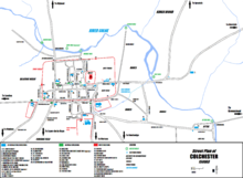
Colchester is a city in northeastern Essex, England. It is the second-largest settlement in the county, with a population of 130,245 at the 2021 Census. The demonym is Colcestrian.

The A12 is a major road in Eastern England. It runs north-east/south-west between London and the coastal town of Lowestoft in the north-eastern corner of Suffolk, following a similar route to the Great Eastern Main Line until Ipswich. A section of the road between Lowestoft and Great Yarmouth became part of the A47 in 2017. Between the junctions with the M25 and the A14, the A12 forms part of the unsigned Euroroute E30. Unlike most A roads, this section of the A12, together with the A14 and the A55, has junction numbers as if it were a motorway.
The Borough of Brentwood is a local government district with borough status in Essex, England. The borough is named after its main town of Brentwood, where the council is based; it includes several villages and the surrounding rural area.

Tiptree is a village and civil parish in the English county of Essex, situated 10 miles (16 km) south-west of Colchester and around 50 miles (80 km) north-east of London. Surrounding villages include Messing, Tolleshunt Knights, Tolleshunt Major, Layer Marney, Inworth, Birch, Great Braxted, Great Totham and Little Totham.

Ingatestone is a village and former civil parish in Essex, England, with a population of 5,409 inhabitants at the 2021 Census. Just north lies the village of Fryerning; the two now forming the parish of Ingatestone and Fryerning, in the Borough of Brentwood. Ingatestone lies in the Metropolitan Green Belt 20 miles north-east of London. Its built-up area straddles the A12 trunk road and the Great Eastern Main Line.

Marks Tey is a large village and electoral ward in Essex, England; it is located six miles west of Colchester.

Colchester is a constituency in Essex represented in the House of Commons of the UK Parliament since 2024 by Pam Cox, of the Labour party.

First Essex is a bus company operating services in the county of Essex. It is a subsidiary of FirstGroup.
Peter Schuyler Bruff was an English civil engineer and land developer remembered primarily for his part in establishing the East Anglian railway networks between the 1840s and 1860s. His contribution to the region's infrastructure and development extended far beyond the railways, however, and included the renovation of the Colchester water supply (1851-1880) and the Ipswich sewerage system, the development of the town of Harwich and the Essex resorts of Walton-on-the-Naze and Clacton on Sea, and the late Victorian revival of the Coalport porcelain factory in Shropshire, which he purchased in 1880.
The Essex and Suffolk Border Football League is a football competition based in England. The league has a total of four divisions headed by the Premier Division which sits at step 7 of the National League System. The top club may apply for promotion to Division One of the Eastern Counties League.

Kelvedon is a village and civil parish in the Braintree District of Essex in England, between Chelmsford and Colchester. It had a population of 4,717 in 2001, reducing to 3,587 at the 2011 Census. It is now home to several businesses including Knight Group and Lysanda. Brockwell Meadows Local Nature Reserve is south-east of the village between a housing estate and the River Blackwater.

The A120 is an A-road in England, which runs between Puckeridge in Hertfordshire and Harwich in Essex.

Colchester in Essex, England, has a number of notable churches.

Tolleshunt Major is a small village approximately five miles north east of Maldon, in the Maldon District of Essex, England. It forms part of the electoral ward of Tolleshunt D'Arcy and is situated on the northern bank of the River Blackwater.

Braintree is a town in Essex, England, and is the principal settlement of Braintree District. It is located 10 miles (16 km) north-east of Chelmsford, 15 miles (24 km) west of Colchester and 35 miles (56 km) north-west of Southend-on-Sea. According to the 2021 Census, the town had a population of 43,492; the urban area, which includes Great Notley, Rayne, Tye Green and High Garrett, had a population of 55,793.

Ipswich is the county town of Suffolk, England. It is a medieval port and industrial town with a strong transport history; the urban area has a population of 122,000 and currently offers urban transport services for cars, cycles and buses. In addition there are 3 railway stations and regional coach services. London Stansted Airport is accessible by the airlink coach.
Tom English is an English former professional footballer who played as a forward for Arsenal where he was a member of the FA youth cup winning squad in 2000 and Marine Castle United in the Singaporean S.League in 2001. His professional career was cut short after he was seriously injured in a fall in Tenerife, though he eventually played semi-professionally for several East Anglian sides. He now works as a postman.
The North Essex League was a football league that was held in Essex, England, founded in 1895.