A172 road (England)

Last updated

UK road A172.svg
A172
Route information
Length16.7 mi (26.9 km)
Major junctions
North end Middlesbrough
54°34′37″N1°13′43″W / 54.5770°N 1.2287°W / 54.5770; -1.2287 (A172 road (northern end))
Major intersectionsUK road A19.svg A19
UK road A173.svg A173
UK road A171.svg A171
UK road A66.svg A66
UK road A174.svg A174
South end Ingleby Arncliffe
54°23′09″N1°19′07″W / 54.3859°N 1.3186°W / 54.3859; -1.3186 (A172 road (southern end))
Location
Country United Kingdom
Constituent country England
Road network
UK road A171.svg A171 UK road A173.svg A173

The A172 is a major road in North Yorkshire, and the unitary authority of Middlesbrough, England. It runs from Ingleby Arncliffe to Middlesbrough. [1] [2] The road derives its adumbrated number from 1969 when a thoroughfare link connected South Teesside with the Lackenby Docks in Middlesbrough. Since further urban infrastructure development it has been extended into the North Yorkshire Moors, when it transforms into A174.

Contents

Route

Marton Road

Marton Road is that part of the length of the A172 that links Middlesbrough to Ladgate Lane. In 1960 Middlesbrough County Borough Council identified a need for the imposition of a speed limit to control congestion in the city.

Marton Road itself runs from the centre of Middlesbrough, starting at around the site of the old St. John's Church and runs to Marton Crossroads at Ladgate Lane. Along its route the road passes several sites of local interest, including the James Cook University Hospital, and Stewart Park. The road can become congested and is famous locally for the "Marton Crawl" which happens during peak times. The Marton Crawl can take anything up to 20 minutes to get from Middlesbrough town centre to Marton itself. This section of the road has ten speed cameras. [3]

Pannierman Lane

Pannierman Lane is that part of the road that is part of the Nunthorpe by-pass, and continues to Stokesley.

Stokesley Road

Cottages along the road Row of Cottages, Marton Road - geograph.org.uk - 55056.jpg
Cottages along the road

On 29 July 1963, The Transport Minister, Ernest Marples announced a new by-pass for the village of Stokesley. This was the origin of the link road. [4] However the edited version of Hansard implies that the new Labour Government re-routed the proposal in 1965 making a Compulsory Purchase Order of the required land. [5] The A172 changes its name to Stokesley Road at Marton Crossroads, passing through Marton-in-Cleveland. The road can be used to join the A19 north to Newcastle and Sunderland and south. The road also joins the A174 (at this point called the Parkway) to the coastal towns of Redcar, Saltburn and Whitby.

There are a number of bus services which operate along part or all of the road. Amongst these are: 27 (Marton-Netherfields), 28 (Saltburn), 29 (Stokesley) and 63 (Redcar), which are operated by Arriva North East.

In May 2016 a section of the road 1.5 miles (2.4 km) long by the Blue Bell Inn was re-surfaced by the Highways Authority at Coulby Newham. [6]

Dixons Bank

Dixons Bank in Nunthorpe Dixon's Bank - geograph.org.uk - 1061098.jpg
Dixons Bank in Nunthorpe

After the junction with Stainton Way, the name changes to Dixons Bank. As of December 2017 major road improvements are underway at a critical junction, Stainton Way in South Middlesbrough, which will widen access, increase traffic flow, increase highway drainage schemes, and improve street lighting. [7]

The road heads south through the Cleveland Hills and Commondale before it joins the A19.

Related Research Articles

<span class="mw-page-title-main">North Riding of Yorkshire</span> Third of a historic county in England

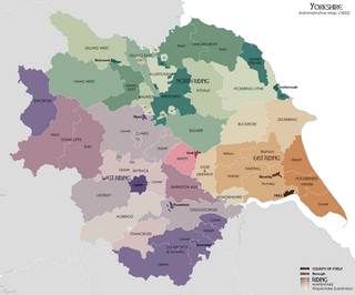
The North Riding of Yorkshire is a subdivision of Yorkshire, England, alongside York, the East Riding and West Riding. The riding's highest point is at Mickle Fell at 2,585 ft (788 m).

<span class="mw-page-title-main">Redcar and Cleveland</span> Borough in North Yorkshire, England

Redcar and Cleveland is a unitary authority area with borough status in North Yorkshire, England.

<span class="mw-page-title-main">Marton, Middlesbrough</span> Area of Middlesbrough, North Yorkshire, England

Marton is an area of Middlesbrough, North Yorkshire, England. Until the 1950s, it was a small village next to the hamlet of Tollesby in Yorkshire's North Riding.

<span class="mw-page-title-main">Saltburn-by-the-Sea</span> Town in North Yorkshire, England

Saltburn-by-the-Sea, commonly referred to as Saltburn, is a seaside town in Redcar and Cleveland, North Yorkshire, England, around 26 miles (42 km) south-east of Hartlepool and southeast of Redcar.

<span class="mw-page-title-main">Esk Valley line</span> Railway line between Middlesbrough and Whitby, England

<span class="mw-page-title-main">Middlesbrough South and East Cleveland (UK Parliament constituency)</span> Parliamentary constituency in the United Kingdom

Middlesbrough South and East Cleveland is a constituency created in 1997 represented in the House of Commons of the UK Parliament since 2017 by Simon Clarke of the Conservative Party.

<span class="mw-page-title-main">Tees Valley line</span> Railway route, in Northern England

The Tees Valley Line is a rail route, in Northern England, following part of the original Stockton and Darlington Railway route of 1825. The line covers a distance of 38 miles (61 km), and connects Bishop Auckland to Saltburn via Darlington, Middlesbrough and 14 other stations in the Teesdale.

<span class="mw-page-title-main">Saltburn, Marske and New Marske</span> Civil parish in North Yorkshire, England

<span class="mw-page-title-main">Langbaurgh Wapentake</span> Former administrative division of Yorkshire, England

<span class="mw-page-title-main">Redcar Central railway station</span> Railway station in North Yorkshire, England

Redcar Central is a railway station on the Tees Valley Line, which runs between Bishop Auckland and Saltburn via Darlington. The station, situated 7 miles 64 chains (12.6 km) east of Middlesbrough, serves the seaside town of Redcar, Redcar and Cleveland in North Yorkshire, England. It is owned by Network Rail and managed by Northern Trains.

<span class="mw-page-title-main">Gypsy Lane railway station</span> Railway station in North Yorkshire, England

Gypsy Lane is a railway station on the Esk Valley Line, which runs between Middlesbrough and Whitby via Nunthorpe. The station, situated 4 miles 3 chains (6.5 km) south-east of Middlesbrough, serves the suburb of Nunthorpe, Redcar and Cleveland in North Yorkshire, England. It is owned by Network Rail and managed by Northern Trains.

<span class="mw-page-title-main">Nunthorpe</span> Village and civil parish in North Yorkshire, England

Nunthorpe is a village and civil parish in the Borough of Middlesbrough in North Yorkshire, England.

<span class="mw-page-title-main">Langbaurgh (UK Parliament constituency)</span> Parliamentary constituency in the United Kingdom, 1983–1997

Langbaurgh was a parliamentary constituency in south Middlesbrough and Redcar and Cleveland boroughs, the latter previously named Langbaurgh from 1974 to 1996. It returned one Member of Parliament (MP) to the House of Commons of the Parliament of the United Kingdom, elected by the first past the post system, and existed from 1983 to 1997.

<span class="mw-page-title-main">Cleveland Hills</span>

The Cleveland Hills are a range of hills on the north-west edge of the North York Moors in North Yorkshire, England, overlooking Cleveland and Teesside. They lie entirely within the boundaries of the North York Moors National Park. Part of the 110-mile (177 km) long Cleveland Way National Trail runs along the hills, and they are also crossed by a section of Wainwright's Coast to Coast Walk. The hills, which rise abruptly from the flat Tees Valley to the north, include distinctive landmarks such as the cone-shaped peak of Roseberry Topping, near the village of Great Ayton – childhood home of Captain James Cook.

<span class="mw-page-title-main">Langbaurgh West</span> Ancient division of the North Riding, Yorkshire, England

Langbaurgh West was a division of the wapentake of Langbaurgh in the North Riding of the ancient county of Yorkshire. The area along with Langbaurgh East forms the Anglo-Saxon baronial Liberty of Cleveland and roughly covers the modern districts of Middlesbrough, the western, urbanised portion of Redcar & Cleveland, the southern portion of Stockton-on-Tees, the northern parts of Hambleton and the northern parts of the Borough of Scarborough.

<span class="mw-page-title-main">Middlesbrough Rural District</span>

The North Yorkshire and South Durham Cricket League, commonly abbreviated to NYSD, is the top-level competition for recreational club cricket in the north of Yorkshire and south of Durham, England. The league was founded as long ago as 1892, the first competition was held in the following year. The league chose to play an official, if shortened, competition after most ECB Premier Leagues formally cancelled the 2020 season due the COVID-19 pandemic.

Roseberry Parkway railway station is a proposed railway station which would be between Nunthorpe and Great Ayton railway stations on the Esk Valley Line, in North Yorkshire, England. The station was proposed in August 2019 by a joint project between Redcar & Cleveland and Middlesbrough Councils and the Tees Valley Combined Authority. The project is "aimed at easing road congestion and improving access to East Cleveland".

<span class="mw-page-title-main">Borough of Middlesbrough</span> Unitary authority area in North Yorkshire, England

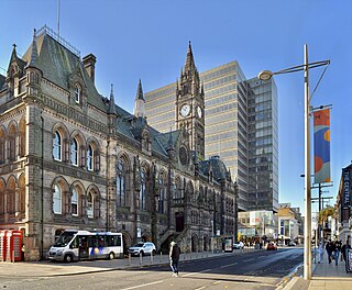
The Borough of Middlesbrough is a borough with unitary authority status in North Yorkshire, England, based around the town of Middlesbrough in the north of the county. It is part of the Tees Valley combined authority, along with Stockton-on-Tees, Redcar and Cleveland, Hartlepool and Darlington boroughs. Nunthorpe along with Stainton and Thornton have statutory parish councils.

References

  1. "A172 road (England)". Rediff.Com. Retrieved 3 September 2013.
  2. "A172 road (England)". Google. Retrieved 3 September 2013.
  3. Speed Cameras Retrieved 2017-12-07
  4. A172 Road. Retrieved 2017-12-07
  5. T Fraser MP. Retrieved 2017-12-08
  6. re-surfacing. Retrieved 2017-12-07
  7. Traffic Schemes. Retrieved 2017-12-07
Map all coordinates using: OpenStreetMap

54°28′59″N1°10′39″W / 54.4830°N 1.1775°W / 54.4830; -1.1775 (A172 road)