Related Research Articles

Thornaby-on-Tees, commonly referred to as Thornaby, is a town and civil parish in the North Yorkshire part of the borough of Stockton-on-Tees, England. The parish had a population of 24,741 at the 2011 census, in the Teesside built-up area. It is located on the south bank of the River Tees.

Norton, also known as Norton-on-Tees, is a market town in the Borough of Stockton-on-Tees, in County Durham, England. The suburbs of Roseworth and Ragworth are notable areas of the town. Billingham Beck is to the east of the town, the beck flows to the south-east. The town also contains the areas of Wolviston and Wynyard which are to the north of the town and are wards of the town. The town had a population of 20,829 in the 2011 Census.

Ingleby Barwick is a town and civil parish in the Borough of Stockton-on-Tees, North Yorkshire, England. It is south of the River Tees and north-east of the River Leven.

Marton or Marton-in-Cleveland is an area of Middlesbrough, North Yorkshire, England. Until the 1950s, it was a small village next to the hamlet of Tollesby in Yorkshire's North Riding.
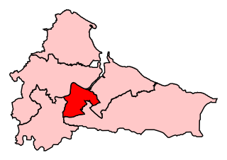
Middlesbrough was a parliamentary constituency in the United Kingdom, recreated in 1974, and represented in the House of Commons of the UK Parliament from 2012 until its abolition for the 2024 general election by Andy McDonald of the Labour Party. An earlier version of the seat existed between 1868 and 1918.

Acklam is an area and electoral ward in the Borough of Middlesbrough, North Yorkshire, England. It is believed that the settlement is Anglo-Saxon in origin, the name is Old English for "place at the oak clearings" or "place of oaks". Acklam was an ancient parish, being known as West Acklam to distinguish it from Acklam in Ryedale.

Ormesby is a village and area split between the unitary authority areas of Middlesbrough and Redcar and Cleveland in North Yorkshire, England.

Nunthorpe is a village and civil parish in the Borough of Middlesbrough in North Yorkshire, England.

Hemlington is an area of Middlesbrough, North Yorkshire, England. It is centred around a lake and is in the Borough of Middlesbrough's south-western outskirts.

Tollesby is a residential area within the Middlesbrough ward of Ladgate in North Yorkshire, England. It is south-east of the Middlesbrough Municipal Golf Course.

The Diocese of Middlesbrough is a Latin diocese of the Catholic Church based in Middlesbrough, England and is part of the province of Liverpool. It was founded on 20 December 1878, with the splitting of the Diocese of Beverley which had covered all of Yorkshire. The Bishop's See is in Coulby Newham, Middlesbrough, at St Mary's Cathedral. Catholic schools in the diocese are run by the Nicholas Postgate Catholic Academy Trust as well as St Cuthbert's Roman Catholic Academy Trust.

Grove Hill is an area of the Middlesbrough's Longlands and Beechwood ward in the Borough of Middlesbrough, North Yorkshire, England. It is a historic part of the North Riding of Yorkshire. The area's main shopping area is off Marton Road at the junction with Marton Burn Road and Belle Vue.

Springwell Village is a village in the City of Sunderland, bordering Gateshead, approximately 7.6 miles (12.2 km) from Newcastle upon Tyne, 9 miles (14 km) from Sunderland, and 13 miles (21 km) from Durham. In 2011, Census data for the City of Sunderland ward of Washington West recorded a total population of 11,833.
St Mary's College was a voluntary aided Catholic college situated in Saltersgill, Middlesbrough, England. Tracing its roots back to 1904, it was the only Catholic further education provision in the region of Teesside for over 50 years.
Saltersgill is an area in the Longlands and Beechwood Ward of Middlesbrough, North Yorkshire, England. In the 2011 census it had a population of 2,679. The area has a TS4 postcode.

Leam Lane Estate is a housing estate in Gateshead, built in the 1950s and early 1960s. Originally made up solely of council-built accommodation and housing association houses, most of the properties are now privately owned. The estate is located around 4 miles (6.4 km) from Newcastle upon Tyne, 10.5 miles (16.9 km) from Sunderland, and 15.5 miles (24.9 km) from Durham. In 2011, Census data for the Gateshead Metropolitan Borough Council ward of Wardley and Leam Lane recorded a total population of 8,327.
Gunnergate Hall was a mansion house with grounds in the south of Middlesbrough in North Yorkshire, England.

Beechwood is a housing estate in the west of Birkenhead, on the Wirral Peninsula, in Merseyside, England. Administratively it is within the Metropolitan Borough of Wirral as part of Bidston and St James Ward. The area is bounded by Bidston to the north, Upton to the west and Noctorum to the south. The elevation of Bidston Hill is immediately to the east.
The Borough of Middlesbrough is a unitary authority area with borough status in the ceremonial county of North Yorkshire, England, based around the town of Middlesbrough in the north of the county. Middlesbrough Council became a unitary authority in 1996. The borough is part of the Tees Valley Combined Authority, along with the boroughs of Stockton-on-Tees, Redcar and Cleveland, Hartlepool and Darlington. There are two parish councils in the area of the borough of Middlesbrough, Nunthorpe and Stainton and Thornton respectively.
References
- ↑ 1,478, UK Census (2011). "Local Area Report – Middlesbrough 014D Lower-layer SOA (E01012052)". Nomis. Office for National Statistics . Retrieved 23 June 2022. and 1,364, UK Census (2011). "Local Area Report – Middlesbrough 014C Lower-layer SOA (E01012051)". Nomis. Office for National Statistics . Retrieved 23 June 2022.
- ↑ UK Census (2011). "Local Area Report – Ladgate Ward (as of 2011) (E05001492)". Nomis. Office for National Statistics . Retrieved 23 June 2022.
- ↑ "'North-east's most unusual church' prepares to celebrate golden anniversary" . Retrieved 23 June 2022.
- ↑ "Teesside University - Sport & well-being - Sports membership scheme". Archived from the original on 19 December 2008. Retrieved 28 October 2009.
- ↑ Enquire Learning Trust. "Easterside Academy" . Retrieved 1 February 2023.
- ↑ Nicholas Postgate Catholic Academy Trust. "St Thomas More RC Primary". St Thomas More RC Primary. Retrieved 1 February 2023.
- ↑ Holmwood School. "Holmwood School". Holmwood School. Retrieved 1 February 2023.
Places adjacent to Easterside | ||||||||||||||||
|---|---|---|---|---|---|---|---|---|---|---|---|---|---|---|---|---|
| ||||||||||||||||