Middlehaven

Last updated

Middlehaven
  • St Hilda's, Over the Border,
    Old Middlesbrough
Former Town Hall, St. Hilda's (geograph 3515221).jpg
North Yorkshire UK location map (2023).svg
Red pog.svg
Middlehaven
Location within North Yorkshire
OS grid reference NZ496210
Unitary authority
Ceremonial county
Region
Country England
Sovereign state United Kingdom
Post town MIDDLESBROUGH
Postcode district TS2
Dialling code 01642
Police Cleveland
Fire Cleveland
Ambulance North East
UK Parliament
List of places
UK
England
Yorkshire
54°34′57″N1°14′02″W / 54.5825°N 1.2338°W / 54.5825; -1.2338

Middlehaven is the oldest part of Middlesbrough, North Yorkshire, England. It is directly south of the River Tees, and north of the current town centre, separated from it by the railway and A66.

Contents

The area has had waves of regeneration since post-war devastation. It currently includes, from west to east: a manufacturing and industrial sector, Boho Zone developments (residential and commercial), the Old Town Hall, the Transporter Bridge, Middlesbrough College, docks, and the Riverside Stadium.

The term St Hilda's for the area relates to the former priory, founded by Hilda of Whitby (the first mention of the town) and later also former church as named after the saint. The railway, and the much later-built A66, separating the area from the rest of the town created the term Over the Border for the area. The name Middlehaven is a back formation from Middlesbrough, combining "Middle" with "haven": the haven relates to Middlesbrough Dock.

History

The 1970s estate of St. Hilda's in 2007 Town Hall, St. Hilda's - geograph.org.uk - 373106.jpg
The 1970s estate of St. Hilda's in 2007

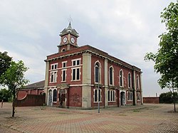
The area formed what was the original town centre of Middlesbrough after its foundation around 1830, [1] and was originally known as St. Hilda's after the parish church of the same name. [2] The district was eventually separated from the southward expansion of the town by the railway in 1846. [1] The Old Town Hall was completed at that time. [3]

By the 1930s, the area had become slums, with overcrowding and high crime, and demolitions begun despite protests from residents. [4] Later, in the 1950s, the clearance continued with sweeping demolitions, and the replacement of the remaining homes by low-rise flat blocks.

Once again, beginning in 1969, there was another wave of demolition, this time replacing the 1950s flats with a suburban housing estate. In the regeneration, St. Hilda's church was demolished. [4]

In 2004, the homes were mostly vacant and plans were announced to demolish the estate, relocating the remaining 300 residents. [5] In the following years, the site was levelled as new developments began in the area, and the area became known as Middlehaven.

Middlesbrough Dock

The dock and Middlesbrough College New Middlesbrough College - geograph.org.uk - 687180.jpg
The dock and Middlesbrough College

The original dock for the 1830 Port Darlington development became too small within a decade of opening, and needed expanding. From 1839–42 under William Cubitt and George Turnbull's plans, the dock was expanded, and formally opened on the 12 May 1842. The dock was designed to have a 80 feet (24 m) entrance channel from the River Tees to the 1:4.4 rectangular dock. The dock was expanded multiple times, growing from 9 acres (0.036 km2) in 1869 to 25 acres (0.10 km2) in 1902. [6]

In 1994, a training ship called the "Tovarisch" was impounded at the dock for five years for being unseaworthy. The rotation of crew from the Kherson marine college played in a local five-a-side league during this time. The ship left on the 29 August 1999 for restoration in Wilhelmshaven, Germany, under funding from the Tall Ships Friends charity and the Ukrainian government. [7]

769,000 long tons (781,000 t) of goods went through the dock in 1978, while the wider ports in the area (under the jurisdiction of Tees and Hartlepool Harbour Police) handled 33,000,000 long tons (34,000,000 t). The dock was unable to compete, and closed in 1980. [6]

See also

Related Research Articles

<span class="mw-page-title-main">North Yorkshire</span> County of England

North Yorkshire is a ceremonial county in the Yorkshire and the Humber and North East regions of England. It borders County Durham to the north, the North Sea to the east, the East Riding of Yorkshire to the south-east, South Yorkshire to the south, West Yorkshire to the south-west, and Cumbria and Lancashire to the west. Northallerton is the county town.

<span class="mw-page-title-main">River Tees</span> East coast river of Northern England

The River Tees, in England, rises on the eastern slope of Cross Fell in the North Pennines and flows eastwards for 85 miles (137 km) to reach the North Sea in the North East of England. The modern-day history of the river has been tied with the industries on Teesside in its lower reaches, where it has provided the means of import and export of goods to and from the North East England. The need for water further downstream also meant that reservoirs were built in the extreme upper reaches, such as Cow Green.

<span class="mw-page-title-main">Stockton-on-Tees</span> Town in County Durham, England

Stockton-on-Tees is a market town in County Durham, England, with a population of 84,815 at the 2021 UK census. It gives its name to and is the largest settlement in the wider Borough of Stockton-on-Tees. It is part of Teesside and the Tees Valley, on the northern bank of the River Tees.

<span class="mw-page-title-main">Middlesbrough</span> Town in North Yorkshire, England

Middlesbrough is a town in North Yorkshire, England. The town lies near the mouth of the River Tees, forming part of the Teesside built-up area, and is located north of the North York Moors National Park. The wider Borough of Middlesbrough had a population 148,215 at the 2021 UK census. Middlesbrough is the largest town of the wider urban Tees Valley area, which had a population of 678,400 in 2021.

<span class="mw-page-title-main">Thornaby-on-Tees</span> Town and civil parish in North Yorkshire, England

Thornaby-on-Tees, commonly referred to as Thornaby, is a town and civil parish in North Yorkshire, England. Situated on the south bank of the River Tees, approximately 3 miles (4.8 km) west of Middlesbrough and roughly 3 miles (4.8 km) south of Stockton, it forms part of the Teesside built-up area. It had a population of 24,741 at the 2011 census. The town is home to Queen's Campus, Durham University.

<span class="mw-page-title-main">Billingham</span> Town in County Durham, England

Billingham is a town and civil parish in County Durham, England. The town is on the north side of the River Tees and is governed as part of the Borough of Stockton-on-Tees unitary authority. It had a population of 35,165 in the 2011 Census.

<span class="mw-page-title-main">Tees Valley</span> Combined authority area in Northern England

Tees Valley is a combined authority area in Northern England, around the lower River Tees. The area is not a geographical valley; the local term for the valley is Teesdale. The combined authority covers five council areas: Darlington, Hartlepool, Middlesbrough, Redcar and Cleveland and Stockton-on-Tees.

<span class="mw-page-title-main">Riverside Stadium</span> Football stadium in Middlesbrough, North Yorkshire, England

The Riverside Stadium is a football stadium in Middlesbrough, England, which has been the home of Middlesbrough since opening in 1995. Its current capacity is 34,742, all seated, although provisional planning permission is in place to expand to 42,000 if required.

<span class="mw-page-title-main">Middlesbrough College</span> Further education college in Middlesbrough, North Yorkshire, England

Middlesbrough College, located on one campus at Middlehaven, Middlesbrough, North Yorkshire, England, is the largest college on Teesside.

<span class="mw-page-title-main">South Bank, Redcar and Cleveland</span> Town in North Yorkshire, England

South Bank is a former industrial town in the Redcar and Cleveland borough in North Yorkshire, England on the south bank of the River Tees. It is 3 miles (4.8 km) east of Middlesbrough and 6 miles (9.7 km) south-west of Redcar. The town is served by South Bank railway station.

<span class="mw-page-title-main">Teesside Park</span> Leisure and shopping centre on Teesside, England

Teesside Park is a retail and leisure park in Thornaby-on-Tees, built in 1988. Located just off the A66 near the A66/A19 interchange, it is split between the unitary authorities of Stockton-on-Tees and Middlesbrough with the line of the Old River Tees, which runs down the middle of the development, forming the boundary between the two authorities. The development has a central building that was constructed in 2008.

<span class="mw-page-title-main">Grangetown, North Yorkshire</span> Area of Redcar and Cleveland in North Yorkshire, England

Grangetown is an area in the borough of Redcar and Cleveland, North Yorkshire, England. The area is 3 miles (4.8 km) east of Middlesbrough and 4 miles (6.4 km) south-west of Redcar.

<span class="mw-page-title-main">A178 road</span> Road in North Yorkshire, England

The A178 is a road that runs from Hartlepool in County Durham to Middlesbrough in North Yorkshire, England.

<i>Temenos</i> (Kapoor) Public artwork in Middlesbrough, England

Temenos is a sculpture in Middlesbrough, Northern England. It is approximately 110 metres (360 ft) long and 50 metres (160 ft) high and cost £2.7 million. The steel structure consists of a pole, a circular ring and an oval ring, all held together by steel wire.

<span class="mw-page-title-main">Tees Viaduct</span> Viaduct over the River Tees in Northern England

The A19 Tees Viaduct or Tees Flyover is a high level six-lane dual carriageway road bridge in the North East of England carrying the main A19 trunk road north–south across the River Tees.

Tees Valley Regeneration was an urban regeneration company covering the Tees Valley area of North East England and at one time was the largest urban development agency in England. The headquarters were at Cavendish House, Teesdale Business Park in Thornaby-on-Tees.

<span class="mw-page-title-main">Tees Marshalling Yard</span> Railway marshalling yard in Middlesbrough, England

Tees Marshalling Yard is a railway marshalling yard, used to separate railway wagons, located near Middlesbrough in North Yorkshire, Northern England.

<span class="mw-page-title-main">History of Middlesbrough</span>

Middlesbrough started as a Benedictine priory on the south bank of the River Tees, its name possibly derived from it being midway between the holy sites of Durham and Whitby. The earliest recorded form of Middlesbrough's name is "Mydilsburgh", containing the term burgh.

<span class="mw-page-title-main">Old Town Hall, Middlesbrough</span> Building in Middlesbrough, England

The Old Town Hall is a municipal building in the Middlehaven area of Middlesbrough, North Yorkshire, England. The building is on East Street and has been vacant since 1996. It is a Grade II listed building with the adjacent clock tower also separately Grade II listed.

Middlesbrough Development Corporation (MDC) is a publicly-owned mayoral development corporation created to fund, manage, and accelerate regeneration in Middlesbrough town centre and Middlehaven, England.

References

  1. 1 2 "From the Archive: Middlesbrough St Hilda's". The Northern Echo. Retrieved 15 July 2022.
  2. "Parishes: Middlesborough | British History Online". british-history.ac.uk. Retrieved 15 July 2022.
  3. Historic England. "Clock Tower c. 5 metres south-west of Old Town Hall, Market Place (1312502)". National Heritage List for England . Retrieved 17 July 2022.
  4. 1 2 "How St Hilda's grew up - then gradually died. - Free Online Library". thefreelibrary.com. Retrieved 15 July 2022.
  5. Live, Teesside. "Got to go". TeessideLive. Retrieved 15 July 2022.
  6. 1 2 Delplanque, Paul (17 November 2011). "Middlesbrough Dock 1839–1980". Evening Gazette . Archived from the original on 9 April 2013. Retrieved 25 February 2023.
  7. "Tall ship to leave after 5 years in British dock". 28 August 1999. Retrieved 25 February 2023.