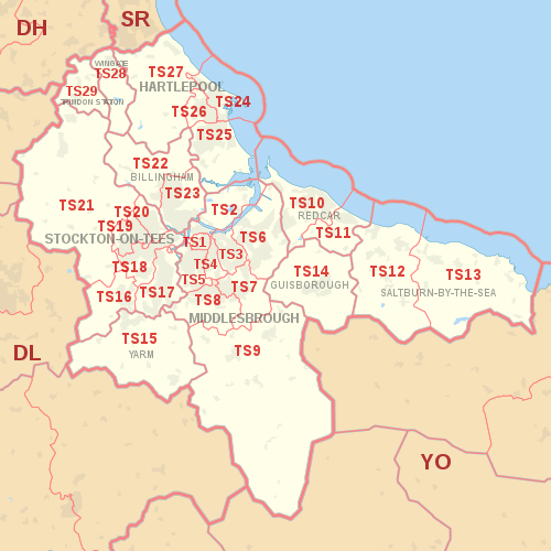
| Postcode district | Post town | Coverage | Local authority area(s) |
|---|
| TS1 | MIDDLESBROUGH | Middlesbrough (town centre) | Middlesbrough |
|---|
| TS2 | MIDDLESBROUGH | St Hilda's, Port Clarence | Middlesbrough, Stockton-on-Tees |
|---|
| TS3 | MIDDLESBROUGH | Middlesbrough's east: Brambles Farm, Thorntree, Park End, North Ormesby, Berwick Hills | Middlesbrough |
|---|
| TS4 | MIDDLESBROUGH | Middlesbrough's centre-east: Beechwood, Easterside, Grove Hill, Longlands, Prissick, Saltersgill | Middlesbrough |
|---|
| TS5 | MIDDLESBROUGH | Middlesbrough's west: Acklam, Ayresome, Brookfield, Linthorpe, Whinney Banks | Middlesbrough |
|---|
| TS6 | MIDDLESBROUGH | Eston, Grangetown, Normanby, Teesville, South Bank | Redcar and Cleveland |
|---|
| TS7 | MIDDLESBROUGH | Middlesbrough's south-east: Marton, Nunthorpe, Ormesby | Middlesbrough, Redcar and Cleveland |
|---|
| TS8 | MIDDLESBROUGH | Middlesbrough's south-west (Coulby Newham, Marton, Hemlington), Stainton, Thornton & Maltby | Middlesbrough, Stockton-on-Tees |
|---|
| TS9 | MIDDLESBROUGH | Great Ayton, Stokesley | North Yorkshire |
|---|
| TS10 | REDCAR | Redcar (town centre), Coatham, Dormanstown, Kirkleatham, Warrenby | Redcar and Cleveland |
|---|
| TS11 | REDCAR | Marske, New Marske | Redcar and Cleveland |
|---|
| TS12 | SALTBURN-BY-THE-SEA | Saltburn, Brotton, Skelton | Redcar and Cleveland |
|---|
| TS13 | SALTBURN-BY-THE-SEA | Loftus, Skinningrove, Staithes | Redcar and Cleveland, North Yorkshire |
|---|
| TS14 | GUISBOROUGH | Guisborough | Redcar and Cleveland |
|---|
| TS15 | YARM | Yarm, Kirklevington, Hutton Rudby | Stockton-on-Tees |
|---|
| TS16 | STOCKTON-ON-TEES | Aislaby, Eaglescliffe, Egglescliffe, Preston-on-Tees (village), Urlay Nook | Stockton-on-Tees |
|---|
| TS17 | STOCKTON-ON-TEES | Ingleby Barwick, Thornaby | Stockton-on-Tees, Middlesbrough |
|---|
| TS18 | STOCKTON-ON-TEES | Stockton's east: town centre, Hartburn, Grangefield, Oxbridge, Portrack | Stockton-on-Tees, County Durham |
|---|
| TS19 | STOCKTON-ON-TEES | Stockton's west: Bishopsgarth, Elm Tree Farm, Fairfield, Hardwick, Newtown, Roseworth | Stockton-on-Tees |
|---|
| TS20 | STOCKTON-ON-TEES | Norton | Stockton-on-Tees |
|---|
| TS21 | STOCKTON-ON-TEES | Bishopton, Carlton, Long Newton, Redmarshall, Stillington, Thorpe Thewles, Sedgefield | Stockton-on-Tees, County Durham |
|---|
| TS22 | BILLINGHAM | Billingham (West), Wolviston, Wynyard | Stockton-on-Tees |
|---|
| TS23 | BILLINGHAM | Billingham (East) | Stockton-on-Tees |
|---|
| TS24 | HARTLEPOOL | Hartlepool (town centre, marina, Stranton), the Headland | Hartlepool |
|---|
| TS25 | HARTLEPOOL | Greatham, Owton, Rift House, Seaton Carew, | Hartlepool |
|---|
| TS26 | HARTLEPOOL | Throston, West Park | Hartlepool |
|---|
| TS27 | HARTLEPOOL | Blackhall Rocks, Blackhall Colliery, Castle Eden, Hesleden, High Hesleden, Hutton Henry | Hartlepool, County Durham |
|---|
| TS28 | WINGATE | Wingate, Station Town | County Durham |
|---|
| TS29 | TRIMDON STATION | Trimdon | County Durham |
|---|