Thorpe Thewles

Last updated
Thorpe Thewles' village green Thorpe Thewles, Vane Arms and village green - geograph.org.uk - 796574.jpg
Thorpe Thewles' village green

Thorpe Thewles is a village which had history dating back to the 12th century. The village shares a parish with Grindon and is in the Borough of Stockton-on-Tees, County Durham, Northern England. It lies near the A177 road between Stockton-on-Tees and Sedgefield.
Contents

Origin of the name

Thorpe is of Danish extraction and means farm, Thorp, and Thewles was likely the name of a family that possessed land here in the Middle Ages: the earliest occurrence of the full name is 'Thorpp' Thewles' in 1265. The surname Thewles probably comes from the Old English theawleas 'immoral', though the meaning of the placename is the Farm of the Thewles Family rather than, as sometimes reported, the Immoral Farm. The name has been confused as North Pewles when in translation. [1]

History

Galfried de Torp was a landowner in the mid-12th century. Members of the Thorp family donated land to the monks of Finchale Priory. The Fulthrope family occupied the manor from 1346 to 1629 while the Kendals, the Sedgewicks, the Tweddells and the Blackstones also owned land from the 16th to 18th centuries. [1]

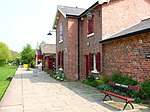
Thorpe Thewles' former railway station Old station at Thorpe Thewles - geograph.org.uk - 167310.jpg
Thorpe Thewles' former railway station

Historic events include the earliest reference to Thorpe Thewles in 1265, the partial rebuilding of St Thomas Church (now a ruin) at Grindon in 1788, [2] a school was built by the Marchioness of Londonderry in 1824, the Holy Trinity Church was built in 1849 but demolished in the 1880s, the railway viaduct was completed in 1877 and the station opened in 1882 and both the St James Church and the Wesleyan Methodist chapel were established in 1887. [1]

Present

St James' Church Thorp Thewles, St James church (geograph 7071905).jpg
St James' Church

The village is currently made up of 182 households and a total population of 477 people.[ citation needed ] The village has a small children's play area, two public houses (the Vane Arms and the Hamilton Russell), a church (St James' Church) and a Parish hall. There is a planetarium, walkway and restaurant at Castle Eden Walkway, the site of the former Thorpe Thewles railway station of the former Castle Eden Railway

Historically, Thorpe Thewles was originally settled in 1692 with only two farmhouses and has grown to have more than 182 households today.

Politics

Thorpe Thewles is located within the civil parish of Grindon and Thorpe Thewles, in the borough of Stockton-on-Tees in the Northern Parishes Ward and the Stockton North constituency. The Member of the UK Parliament for Thorpe Thewles is Alex Cunningham and the local councilor for Thorpe Thewles is John Gardner.

Related Research Articles

Yarm Town and civil parish in North Yorkshire, England

Yarm, also referred to as Yarm-on-Tees, is a market town and civil parish in the Borough of Stockton-on-Tees, North Yorkshire, England. It was previously a port town before the industry moved down the River Tees to more accessible settlements nearer to the sea.

Stockton-on-Tees Town in County Durham, England

Stockton-on-Tees, simply Stockton, is a large market town in the Borough of Stockton-on-Tees, County Durham, England. It is between the towns of Darlington, Hartlepool and Middlesbrough; to the west, north-east and east respectively.

Thornaby-on-Tees Town and civil parish in North Yorkshire, England

Thornaby-on-Tees, commonly referred to as Thornaby, is a town and civil parish on the River Tees's southern bank. It is in the Borough of Stockton-on-Tees, North Yorkshire, England. The parish had a population of 24,741 at the 2011 census, in the Teesside built-up area.

A19 road Road in Northern England

The A19 is a major road in England running approximately parallel to and east of the A1 road. Although the two roads meet at the northern end of the A19, the two roads originally met at the southern end of the A19 in Doncaster, but the old route of the A1 was changed to the A638. From Sunderland northwards, the route was formerly the A108. In the past the route was known as the East of Snaith-York-Thirsk-Stockton-on-Tees-Sunderland Trunk Road. Most traffic joins the A19, heading for Teesside, from the A168 at Dishforth Interchange.

Ingleby Barwick Town and civil parish in North Yorkshire, England

Ingleby Barwick is a town and civil parish in the Borough of Stockton-on-Tees, North Yorkshire, England. It is south of the River Tees and north-east of the River Leven.

Aislaby, County Durham Human settlement in England

Aislaby ) is a small village and civil parish on the north bank of the River Tees within the borough of Stockton-on-Tees and the ceremonial county of County Durham, England. It is located to the west of Eaglescliffe and Yarm. The name, first attested as Asulue(s)bi in 1086, is of Viking origin and means "Aslak's farm." Aislaby was listed in the Domesday Book of 1086.

Carlton, County Durham Human settlement in England

Carlton is a village and civil parish within the borough of Stockton-on-Tees and ceremonial county of County Durham, England. The population of the civil parish taken at the 2011 census was 726. It is situated a few miles to the north-west of Stockton-on-Tees, a short distance from the village of Redmarshall.

Castle Eden Human settlement in England

Castle Eden is a village in County Durham, in England. The population of the parish at the 2011 census was 642. It is situated a short distance to the south of Peterlee, Wingate, Hutton Henry, the A19 and Castle Eden Dene. The village is famous for the former Castle Eden Brewery which was home of the famous Castle Eden Ale; most of it was demolished in 2003 for a new housing estate and only the main front building remains today. This is a listed building and is now managed office space with a popular Italian restaurant. The A19 used to run through the village until it was bypassed in the 1970s. The deep and impressive nearby dene extends all the way to sea, and its many yew trees are a particular feature where they find the dolomite soil advantageous.

Piercebridge Human settlement in England

Piercebridge is a village and civil parish in the borough of Darlington and the ceremonial county of Durham, England. The population of the civil parish as of the 2011 census was 113. It is situated a few miles west of the town of Darlington. It is on the site of a Roman fort of AD 260–270, which was built at the point where Dere Street crossed the River Tees. Part of the fort is under the village green. The village is sited where the York-Newstead Roman road known as Dere Street crosses the River Tees.

Hilton, North Yorkshire Village and civil parish in North Yorkshire, England

Hilton is a village and civil parish in the borough of Stockton-on-Tees and the ceremonial county of North Yorkshire, England. It is a small village with an estimated population of around 400, measured at 374 in the 2011 census. Despite its proximity to Teesside, the village retains its rural feel, and has a number of public footpaths surrounding it.

Egglescliffe Village and civil parish in County Durham, England

Egglescliffe is a village and civil parish in County Durham, England. Administratively it is located in the borough of Stockton-on-Tees. It shares a civil parish with Eaglescliffe.

Little Stainton Human settlement in England

Little Stainton is a village in the borough of Darlington and the ceremonial county of County Durham, England. It is a township in the parish of Bishopton, County Durham, situated a few miles west of Stockton-on-Tees. From the Census 2011 the population of Little Stainton has included that of Great Stainton and was 193. It is a hamlet, consisting of houses and farms that have no local service facilities. On one side of the street, a stream—Bishopton Beck—runs along the bottom of the gardens.

Grindon, County Durham Village in County Durham, England

Grindon is a village in the borough of Stockton-on-Tees, County Durham, England. The civil parish population at the census 2001 was 2,603 reducing to 2,484 at the 2011 Census. It is situated between Sedgefield and Stockton-on-Tees, near to Thorpe Thewles and Thorpe Larches.

Redmarshall Human settlement in England

Redmarshall is a village and civil parish in the borough of Stockton-on-Tees and ceremonial county of County Durham, England. The population as of the 2011 census was 287. Redmarshall is situated to the west of Stockton-on-Tees, just north of the A66 road which is one of the main trunk routes through Teesside. It is home to the Church of Saint Cuthbert and a pub called The Ship. It has a green in the centre and roads such as Church Lane, Coniston Crescent and Windermere Avenue, named after waters in the Lake District. Ferguson Way is the newest addition to the village. A small wood is a short way out of the village and down a bank past Ferguson Way. There is a new housing estate called the langtons being built on the old remains of the mains care home.

Stockton North (UK Parliament constituency) Parliamentary constituency in the United Kingdom, 1983 onwards

Stockton North is a constituency covering the town of Stockton-on-Tees in County Durham and other nearby settlements in the Borough of Stockton-on-Tees located north of the River Tees, represented in the House of Commons of the UK Parliament since 2010 by Alex Cunningham, a member of the Labour Party. In November 2021 Mr Cunningham announced his intention to retire at the next General Election.

Holy Trinity Church was a now demolished church in the village of Thorpe Thewles, County Durham, England.

Castle Eden Railway

The Castle Eden Railway was a railway line built by the North Eastern Railway between Bowesfield Junction near Stockton-on-Tees and Wingate, County Durham, Northeast England. Although its route actually never went near Castle Eden, it was also informally known as the "Cuckoo Line".

Thorpe Thewles railway station

Thorpe Thewles railway station was a railway station on the Castle Eden branch of the North Eastern Railway (NER) from 1880 to 1931. It was located approximately 5 miles north of Stockton and was designed to serve the village of Thorpe Thewles and the civil parish of Grindon in Stockton-on-Tees, part of the Ceremonial County of Durham, North East England but, despite its name, was actually located further from the village of Thorpe Thewles than Carlton station on the main line of the Clarence Railway.

References

  1. 1 2 3 "Thorpe Thewles". Cleveland & Teesside Local History Society. Retrieved 1 March 2020.
  2. "The Remains of The Church of St. THOMAS OF CANTERBURY, Grindon". Thorpe Thewles. Retrieved 1 March 2020.

Coordinates: 54°36′N1°23′W / 54.600°N 1.383°W / 54.600; -1.383