Wolviston

Last updated

Wolviston High Street Ship Inn, Wolviston - geograph.org.uk - 283365.jpg
Wolviston High Street
St Peter's Church Wolviston, St Peter's church (geograph 7424397).jpg
St Peter's Church

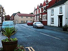
Wolviston is a village and civil parish within the borough of Stockton-on-Tees and the ceremonial county of County Durham, England. The population of the civil parish as of the 2011 census was 877. [1] It is situated in the north of Billingham. The village has several businesses, including a florist, saddlery, international consultancy firm, riding school and post office. Wolviston benefits from two pubs, the Wellington Inn and the Ship. It has a traditional village green and a duck pond. [2]

Contents

History

Wolviston can be traced back to before the Norman Conquest (1066), with name changes that appear to be related to Saxon times. In the 11th century it was known as Olverstona, in the 16th as Wulston and as Woulston in the late 17th century. In 1577 Wolviston became a separate parish. There have been two churches in the village. The first, from the 12th century and dedicated to St Mary Magdelene, fell into disrepair in the 16th century but was restored in 1716. In 1876 a new church dedicated to St Peter was built behind the High Street and the old church was demolished in 1878. The new building was renovated in 1969–1972. [3] [4]

The village today

The village community centre Wolviston Village Community Centre - geograph.org.uk - 1809575.jpg
The village community centre

Wolviston is a community with a cricket and a Wearside League football team, a guides association and allotment holders' club. [5]

Near to Wolviston in Wynyard is Wynyard Hall, historically the family home of the Londonderry dynasty, whose fortune came from the ownership of several collieries and a port in County Durham. The present Wynyard Hall was completed in 1848 and many royal visitors were entertained there over the following hundred years. The war memorial commemorates the Wolviston casualties in both World Wars. [6]

The A19 ran through the village until it was bypassed in the 1970s to the east then in the 1980s bypassed to the west when the original bypass became gridlocked towards Billingham and Stockton during rush hours. The A689 also used to run through the village but was bypassed to the north in the 1970s. [7]

Related Research Articles

<span class="mw-page-title-main">Stockton-on-Tees</span> Town in County Durham, England

Stockton-on-Tees is a market town in County Durham, England, with a population of 84,815 at the 2021 UK census. It gives its name to and is the largest settlement in the wider Borough of Stockton-on-Tees. It is part of Teesside and the Tees Valley, on the northern bank of the River Tees.

<span class="mw-page-title-main">Thornaby-on-Tees</span> Town and civil parish in North Yorkshire, England

Thornaby-on-Tees, commonly referred to as Thornaby, is a town and civil parish in North Yorkshire, England. Situated on the south bank of the River Tees, approximately 3 miles (4.8 km) west of Middlesbrough and roughly 3 miles (4.8 km) south of Stockton, it forms part of the Teesside built-up area. It had a population of 24,741 at the 2011 census. The town is home to Queen's Campus, Durham University.

<span class="mw-page-title-main">Norton, County Durham</span> Town and civil parish in County Durham, England

Norton, also known as Norton-on-Tees, is a market town in the Borough of Stockton-on-Tees, in County Durham, England. The suburbs of Roseworth and Ragworth are notable areas of the town. Billingham Beck is to the east of the town, the beck flows to the south-east. The town also contains the areas of Wolviston and Wynyard which are to the north of the town and are wards of the town. The town had a population of 20,829 in the 2011 Census.

<span class="mw-page-title-main">Borough of Stockton-on-Tees</span> Unitary authority area in County Durham, England

The Borough of Stockton-on-Tees is a local government district with borough status which straddles the ceremonial counties of County Durham and North Yorkshire, England. Since 1996 its council has been a unitary authority, being a district council which also performs the functions of a county council. The borough had a population of 196,600 in 2021.

<span class="mw-page-title-main">Billingham</span> Town in County Durham, England

Billingham is a town and civil parish in County Durham, England. The town is on the north side of the River Tees and is governed as part of the Borough of Stockton-on-Tees unitary authority. It had a population of 35,165 in the 2011 Census.

<span class="mw-page-title-main">Tees Valley</span> Combined authority area in Northern England

Tees Valley is a combined authority area in Northern England, around the lower River Tees. The area is not a geographical valley; the local term for the valley is Teesdale. The combined authority covers five council areas: Darlington, Hartlepool, Middlesbrough, Redcar and Cleveland and Stockton-on-Tees.

Longnewton is a village and civil parish in the borough of Stockton-on-Tees and ceremonial county of County Durham, England. The population taken at the 2001 Census was 733 increasing to 828 at the 2011 Census. It is situated between Darlington and Stockton-on-Tees. The village is mostly privately owned dwellings, and has a public house, The Derry, St. Mary's church and Saint Mary's Church of England primary school. Longnewton is not home to a secondary school however it is in the catchment area for Egglescliffe Secondary School, which is located 3 miles away and around a 10-minute drive. Located in the village is also a community centre, most commonly known as the Wilson Centre which has 3 different venue rooms, for a variety of activities and occasions. Longnewton is also a 10 minutes drive north of Teesside International Airport. In March 2007 a new bypass and junction on the A66 which runs just north of the village was created after almost 30 years of proposals, the junction was fully open to traffic in May 2008. A new roundabout has been put in place to service Teesside International Airport and ease traffic levels around the surrounding area.

<span class="mw-page-title-main">Embleton, County Durham</span> Human settlement in England

Embleton is a hamlet and former civil parish, now in the parish of Sedgefield, in the County Durham district, in the ceremonial county of Durham, in England, as well as the site of a medieval village and manor. It is situated 3 miles (5 km) east of Sedgefield and 4 miles (6 km) west of Hartlepool. In 1961 the parish had a population of 80. The township was historically named "Elmdene", supposedly derived from the site's proximity to a woodland of elm trees which, at an earlier time, flourished in the bordering dene. A single farmstead now occupies the site which lies adjacent to the ruins of a small church dedicated to the Virgin Mary.

<span class="mw-page-title-main">Grindon, County Durham</span> Village in County Durham, England

Grindon is a village and former civil parish, now in the parish of Grindon and Thorpe Thewles, in the Stockton-on-Tees district, in the ceremonial county of Durham, England. The civil parish population at the census 2001 was 2,603 reducing to 2,484 at the 2011 Census. In the 2021 census, the population of Grindon and Thorpe Thewles parish, now no longer including Wynyard, was 940. It is situated between Sedgefield and Stockton-on-Tees, near to Thorpe Thewles and Thorpe Larches.

Redmarshall is a village and civil parish in the borough of Stockton-on-Tees and ceremonial county of County Durham, England. The population as of the 2011 census was 287. Redmarshall is situated to the west of Stockton-on-Tees, just north of the A66 road which is one of the main trunk routes through Teesside. It is home to the Church of Saint Cuthbert and a pub called The Ship. It has a green in the centre and roads such as Church Lane, Coniston Crescent and Windermere Avenue, named after waters in the Lake District. Ferguson Way is the newest addition to the village. A small wood is a short way out of the village and down a bank past Ferguson Way. There is a new housing estate called the langtons being built on the old remains of the mains care home.

<span class="mw-page-title-main">Thorpe Thewles</span>

Thorpe Thewles is a village which had history dating back to the 12th century. The village shares a parish with Grindon and is in the Borough of Stockton-on-Tees, County Durham, Northern England. It lies near the A177 road between Stockton-on-Tees and Sedgefield.

<span class="mw-page-title-main">Stockton North (UK Parliament constituency)</span> Parliamentary constituency in the United Kingdom, 1983 onwards

Stockton North is a constituency covering the town of Stockton-on-Tees in County Durham and other nearby settlements in the Borough of Stockton-on-Tees located north of the River Tees, represented in the House of Commons of the UK Parliament since 2010 by Alex Cunningham, a member of the Labour Party.

<span class="mw-page-title-main">Wearside Football League</span> Association football league in England

The Wearside Football League is a non-league football competition based in northern England. It consists of three divisions which sits at steps 7 to 9 of the National League System and is a feeder to the Northern League Division Two.

<span class="mw-page-title-main">Greatham, County Durham</span> Village and civil parish in Hartlepool, County Durham, England

Greatham is a village and civil parish in the borough of Hartlepool, County Durham, England. The population of the civil parish was taken in the 2011 census was 2,132. Greatham village is located approximately three miles south of Hartlepool town centre.

<span class="mw-page-title-main">County Borough of Teesside</span> Former district in northern England

The County Borough of Teesside was a county borough in the north-east of England, which existed for just six years. It was created in 1968 to cover the Teesside conurbation which had grown up around the various port and industrial towns near the mouth of the River Tees. The council was based in Middlesbrough, the area's largest town. The county borough was abolished in 1974 on the creation of the new county of Cleveland, which covered a larger area, with the county borough's territory being split between three of the four districts created in the new county. In 1971 it had a population of 396,233.

<span class="mw-page-title-main">Wynyard, County Durham</span> Human settlement in England

Wynyard is a garden village in County Durham, England.

<span class="mw-page-title-main">Thorpe Thewles railway station</span> Former railway station in England

Thorpe Thewles railway station was a stop on the Castle Eden branch of the North Eastern Railway (NER) from 1880 to 1931. It was located approximately 5 miles north of Stockton and was designed to serve the village of Thorpe Thewles and the civil parish of Grindon in Stockton-on-Tees, part of the Ceremonial County of Durham, North East England. Despite its name, the station was actually located further from the village of Thorpe Thewles than Carlton station on the main line of the Clarence Railway.

Wynyard railway station was a railway station on the Castle Eden branch of the North Eastern Railway (NER) from 1880 to 1931. It was located immediately to the south of the bridge carrying the Hartlepool to Sedgefield road and served little more than a few scattered hamlets, including Embleton and Swainston. Despite its name, the station was poorly situated for Wynyard Park which was better served by the neighbouring station at Thorpe Thewles.

References

  1. "Civil Parish population 2011" . Retrieved 2 February 2016.
  2. Mackenzie, Eneas; Ross, Marvin (1834). An Historical, Topographical, and Descriptive View of the County Palatine of Durham: Comprehending the Various Subjects of Natural, Civil, and Ecclesiastical Geography, Agriculture, Mines, Manufactures, Navigation, Trade, Commerce, Buildings, Antiquities, Curiosities, Public Institutions, Charities, Population, Customs, Biography, Local History, &c. Mackenzie and Dent. pp.  513–.
  3. Fellowes, P. "A Brief History of Wolviston Village". The Wolviston Boys. Retrieved 1 March 2020.
  4. "Wolviston". Cleveland / Teesside Local History Society. Retrieved 1 March 2020.
  5. "Wolviston's dreams of Lord's fast approaching reality". The Northern Echo. 7 August 2001. Retrieved 1 March 2020.
  6. "A look back at the history of Wynyard Hall - and the great and the good who have stayed there". Teesside Live. Retrieved 1 March 2020.
  7. "Billingham". England's North East. Retrieved 1 March 2010.

54°37′N1°17′W / 54.617°N 1.283°W / 54.617; -1.283