Somerleyton is a village and former civil parish, now in the parish of Somerleyton, Ashby and Herringfleet, in the East Suffolk district, in the north of the English county of Suffolk. It is 4.5 miles (7.2 km) north-west of Lowestoft and 5.5 miles (8.9 km) south-west of Great Yarmouth. The village is closely associated with Somerleyton Hall and was largely rebuilt as a model village in the 19th century at the direction of Samuel Morton Peto. The parish was combined with Herringfleet and Ashby to create the parish of "Somerleyton, Ashby and Herringfleet" on 1 April 1987.

Shalford is a village and civil parish in the Guildford district, in Surrey, England on the A281 Horsham road immediately south of Guildford. It has a railway station which is between Guildford and Dorking on the Reading to Gatwick Airport line. In 2011 the parish had a population of 4,142.
Bagnor is a village close to the town of Newbury in the English county of Berkshire and situated on the banks of the River Lambourn. At the 2011 census the population was included in the civil parish of Speen. It is best known as the home of the Watermill Theatre.

Alfold is a village and civil parish in Surrey, England on the West Sussex border. Alfold is a dispersed or polyfocal village in the Green Belt, which is buffered from all other settlements. The Greensand Way runs north of the village along the Greensand Ridge and two named localities exist to the north and south of the historic village centre which features pubs, a set of stocks and a whipping post.

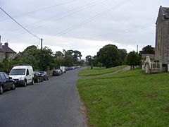
Hutton Magna is a village and civil parish in County Durham, England. Situated 7.6 miles (12.2 km) southeast of Barnard Castle. Lying within the historic boundaries of the North Riding of Yorkshire, the village along with the rest of the former Startforth Rural District has been administered by County Durham since 1 April 1974, under the provisions of the Local Government Act 1972. The civil parish also includes the hamlet of Lane Head.

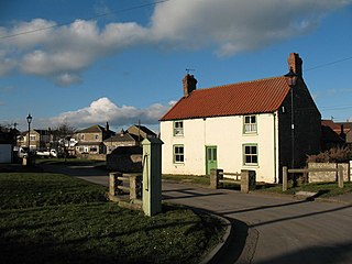
Scargill is a hamlet in the Pennines of England, situated close to the River Greta. The population taken at the 2011 Census was less than 100. Details are kept in the parish of Barningham. It lies within the historic boundaries of the North Riding of Yorkshire, but along with the rest of the former Startforth Rural District it was transferred to County Durham for administrative and ceremonial purposes on 1 April 1974, under the provisions of the Local Government Act 1972.

Stoke d'Abernon is a village and former civil parish in the Elmbridge district, in Surrey, England. It is on the right bank of the River Mole contiguously south of Cobham, a larger settlement which is a post town and is east-southeast of Oxshott a large village founded in the 19th century from the higher, sandy forested part of its formerly expansive area. It shares a railway station with Cobham and is inside the M25 motorway. Cobham Training Centre, the training ground of Chelsea F.C., is within its traditional boundaries.

Halberton is a village and civil parish in Devon, England. It is situated between the historic market towns of Tiverton and Cullompton. The Grand Western Canal runs around to the north and west of the village.

Bintree is a village and civil parish in the English county of Norfolk.

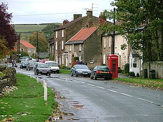
Newsham is a village and civil parish in the former Richmondshire district of North Yorkshire, England. The village is 8 miles (13 km) north west of Richmond and 13 miles (21 km) south west of Darlington.
Gilling West is a village about 3.5 miles (5.6 km) north of Richmond in North Yorkshire, England. It is located in the civil parish of Gilling with Hartforth and Sedbury. It is named "West" to distinguish it from Gilling East near Helmsley, some 32 miles away.

Gilling East is a village and civil parish in North Yorkshire, England, on the main B1363 road between York and Helmsley, 2 miles (3.2 km) south of Oswaldkirk and 5 miles (8 km) south of Helmsley. It is named "East" to distinguish it from Gilling West near Richmond, some 32 miles (51 km) away. It had a population of 321 at the 2001 Census, which had risen to 345 at the 2011 census. In 2015, North Yorkshire County Council estimated the population to be 360. The village lies in the Howardian Hills just south of the North York Moors National Park and close to Ampleforth Abbey and College.
Snape is a large village in the civil parish of Snape with Thorp in the former Hambleton District of North Yorkshire, England, located about 3 miles (5 km) south of Bedale and 3 miles (5 km) west of the A1(M) motorway, it has a population of 350. Nearby is Thorp Perrow Arboretum. The name is Old Norse for a boggy tract of uncultivated land.

Thorpe is a village in northwest Surrey, England, around 20 miles (32 km) west of central London. It is in the Borough of Runnymede, between Egham, Virginia Water and Chertsey. It is adjacent to the M25, near the M3 — its ward covers 856 hectares (3.3 sq mi). Its traditional area with natural boundaries covers one square mile less. Thorpe is a former civil parish.
Witley Park, formerly known as Lea Park, is an estate dating from the late 19th century between Godalming and Haslemere in Surrey, England. Its landscaped grounds include three artificial lakes, one of which conceals an underwater conservatory and smoking room. The mansion house, rebuilt for the swindler Whitaker Wright, was gutted by fire in October 1952 and the ruins were demolished in January 1954. In the early 21st century, a new house was built on the site.
Duncton is a village and civil parish in the District of Chichester in West Sussex, England. The village is in the South Downs 3 miles (5 km) south of Petworth on the A285 road.

Londonthorpe is a village in the civil parish of Londonthorpe and Harrowby Without, in South Kesteven district of Lincolnshire, England. It lies 3 miles (5 km) to the north-east from Grantham, 1 mile (1.6 km) to the west from the B6403, and borders Belton Park in the west.

St Peter South Elmham is a village and civil parish in the north of the English county of Suffolk. It is around 3 miles (4.8 km) south of the market town of Bungay in the East Suffolk district. It is one of the villages surrounding Bungay which make up the area known as The Saints.
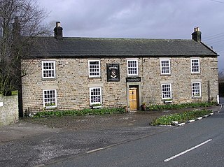
The Milbank Arms is a Grade II listed public house at Barningham, County Durham. Built in the early 19th century, it spent a period as a hotel before converting to a public house. It was one of the last public houses in the country to not include a bar counter when one was fitted in 2018. The public house, and former hotel, are named after local land owning family, the Milbanks, who have recently taken over the license.

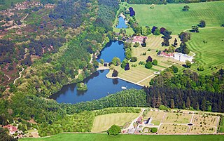
Barningham Park is a Grade II* listed country house and 7,000 acre estate located in the village of Barningham, County Durham, England.