Witton-le-Wear

Last updated • 4 min readFrom Wikipedia, The Free Encyclopedia

Witton-le-Wear
The Victoria , School Street , Witton-le-Wear - geograph.org.uk - 306750.jpg
School Street, Witton-le-Wear
Durham UK location map.svg
Red pog.svg
Witton-le-Wear
Location within County Durham
Population690 (2011) [1]
OS grid reference NZ150320
Unitary authority
Ceremonial county
Region
Country England
Sovereign state United Kingdom
Post town BISHOP AUCKLAND
Postcode district DL14
Dialling code 01388
Police Durham
Fire County Durham and Darlington
Ambulance North East
UK Parliament
List of places
UK
England
County Durham
54°40′36″N1°46′24″W / 54.676734°N 1.773391°W / 54.676734; -1.773391

Witton-le-Wear is a village in County Durham, North East England. It is situated on the north bank of the River Wear, 6 km (3.7 mi) to the north-west of Bishop Auckland.

Contents

Geography and administration

Witton-le-Wear is part of the North West Durham Parliamentary constituency, and is represented by Richard Holden (Conservative). The village is within Weardale Ward, which elects two councillors to Durham County Council. The current councillors are Anita Savory (Independent) and John Shuttleworth (Independent). Witton-le-Wear also has an eight-member Parish Council.

The local police force is Durham Constabulary. Witton-le-Wear is in the Wear and Tees division.

History

Etymology

The place name Witton or Whitton is fairly common in the north of England. While the name can mean "white farm", in the case of Witton-le-Wear Witton refers to a farm (Anglo-Saxon: ton) in or near woodland (Anglo-Saxon: widu). Witton-le-Wear's name is attested as Wudeton from 1104, but had become Wotton in Werdale by 1313. This subsequently evolved to the present form. [2]

Industrial history

The farming hamlet of Witton-le-Wear was part of the Witton Castle estate, which was bought in 1816 by Sir William Chaytor for £78,000 from the Stobart family. He redeveloped the castle, and in 1819 developed the Jayne Pitt as part of the large Witton Park Colliery complex. This brought about the development of transport into the area, including the Etherley Incline Railway by George Stephenson, that connected to the Stockton and Darlington Railway (S&DR) at Shildon, and hence onwards via Stockton to Newport on the River Tees.

After the S&DR was extended into Bishop Auckland, the railway was able to access the limestone deposits within the upper River Wear valley. This brought employment to the valley through both mining, as well as production of both pig iron and cement, which was distributed by the railway to all parts of the United Kingdom.

Recent history

As the price of road haulage dropped, the railway fell into disuse and carried its last train in the early 1990s. Over recent years the Weardale Railway has been reinstated by the British American Railway Services (BARS) and is again used to transport locally mined opencast coal to Scunthorpe and Ratcliffe-on-Soar Power Station.

The line is also run as a heritage railway, operating on many weekends and holidays by Weardale Railway Trust in conjunction with the BARS, and provides a tourist route in and out of Weardale. A weekend halt has been provided at Witton-le-Wear since early 2013.

Amenities

Witton-le-Wear's last village shop closed in 1998, meaning the village's only permanent amenities are its two public houses, The Dun Cow and the Victoria. There are two churches, the Anglican Church of St Philip and St James, and the Primitive Methodist Chapel. The two churches share a congregation and use each building alternately for services. Witton's original Board School was erected in 1874, and replaced in 1968 with a new primary school in St James Gardens. There are around 100 pupils attending from Witton-le-Wear and surrounding villages. The original school now provides a Community Centre for the village which is used most days by a variety of groups and organisations.

Witton Castle Country Park is situated over the River Wear from the village and consists of a 15th-century castle and grounds.

Landmarks

In the village is Witton Tower, a medieval pele tower with later additions. [3] The village green has been a major feature of the village for over 200 years. The trees along the top were planted to celebrate Queen Victoria's Diamond Jubilee in 1897. Further trees have been added to celebrate the Silver and Golden Jubilees of Queen Elizabeth II and other important occasions.

Notable residents

Related Research Articles

<span class="mw-page-title-main">Stockton and Darlington Railway</span> English railway company, 1825 to 1863

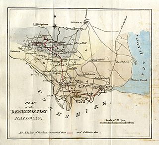
The Stockton and Darlington Railway (S&DR) was a railway company that operated in north-east England from 1825 to 1863. The world's first public railway to use steam locomotives, its first line connected collieries near Shildon with Darlington and Stockton in County Durham, and was officially opened on 27 September 1825. The movement of coal to ships rapidly became a lucrative business, and the line was soon extended to a new port at Middlesbrough. While coal waggons were hauled by steam locomotives from the start, passengers were carried in coaches drawn by horses until carriages hauled by steam locomotives were introduced in 1833.

<span class="mw-page-title-main">Bishop Auckland</span> Town and civil parish in County Durham, England

Bishop Auckland is a market town and civil parish at the confluence of the River Wear and the River Gaunless in County Durham, England. It is 12 miles (19 km) northwest of Darlington and 12 miles (19 km) southwest of Durham.

<span class="mw-page-title-main">County Durham</span> County of England

County Durham, officially simply Durham (/ˈdʌrəm/), is a ceremonial county in North East England. The county borders Northumberland and Tyne and Wear to the north, the North Sea to the east, North Yorkshire to the south, and Cumbria to the west. The largest settlement is Darlington.

<span class="mw-page-title-main">Weardale Railway</span> Heritage railway in County Durham, England

The Weardale Railway is an independently owned British single-track branch line heritage railway between Bishop Auckland, Witton-le-Wear, Wolsingham, Frosterley and Stanhope. Weardale Railway began services on 23 May 2010, but decided to run special trains rather than a scheduled service for the 2013 season. The line was purchased by the Auckland Project in 2020 with a view to restarting passenger services. In 2021, a bid was submitted to the Restoring Your Railway fund. In October 2021, the Department for Transport allocated funding for the development of a business case.

<span class="mw-page-title-main">Wolsingham</span> Human settlement in England

Wolsingham is a market town in Weardale, County Durham, England. It is situated by the River Wear, between Crook and Stanhope.

<span class="mw-page-title-main">Weardale</span> Open valley in County Durham, England

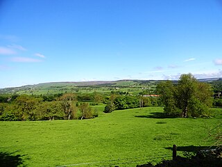
Weardale is a dale, or valley, on the east side of the Pennines in County Durham, England. Large parts of Weardale fall within the North Pennines Area of Outstanding Natural Beauty (AONB) – the second-largest AONB in England and Wales. The upper dale is surrounded by high fells and heather grouse moors. The River Wear flows through Weardale before reaching Bishop Auckland and then Durham, meeting the sea at Sunderland.

<span class="mw-page-title-main">Escomb</span> Village in England

Escomb is a village and former civil parish on the River Wear about 1+12 miles (2.4 km) west of Bishop Auckland, in the County Durham district, in the ceremonial county of Durham, England. In 2001 it had a population of 358. In 2011 the ward had a population of 3323.

<span class="mw-page-title-main">Stanhope, County Durham</span> Town in County Durham, England

Stanhope is a market town and civil parish in the County Durham district, in the ceremonial county of Durham, England. It lies on the River Wear between Eastgate and Frosterley, in the north-east of Weardale. The main A689 road over the Pennines is crossed by the B6278 between Barnard Castle and Shotley Bridge. In 2001 Stanhope had a population of 1,633, in 2019 an estimate of 1,627, and a figure of 1,602 in the 2011 census for the ONS built-up-area which includes Crawleyside. In 2011 the parish population was 4,581.

<span class="mw-page-title-main">Bishop Auckland railway station</span> Railway station in County Durham, England

Bishop Auckland is a railway station that serves the market town of Bishop Auckland in County Durham, North East England, 11 miles 77 chains (19.3 km) north-west of Darlington. The station is the Western terminus of the Tees Valley Line, which links it to Saltburn via Darlington. It is owned by Network Rail and managed by Northern Trains.

<span class="mw-page-title-main">River Wear</span> River in northeast England

The River Wear in Northern England rises in the Pennines and flows eastwards, mostly through County Durham, to the North Sea in the City of Sunderland. At 60 mi (97 km) long, it is one of the region's longest rivers. The Wear wends in a steep valley through the cathedral city of Durham and gives its name to Weardale in its upper reach and Wearside by its mouth.

Witton Park Colliery was a coal mine located in Witton Park, near Witton-le-Wear and Bishop Auckland in County Durham, Northern England.

<span class="mw-page-title-main">Durham to Bishop Auckland Line</span> Railway line in County Durham, England

The Durham to Bishop Auckland Line was a railway line originally built by the North Eastern Railway (NER) to provide rail transport access to coal mines in West County Durham. It closed under the Beeching Axe to passenger traffic in May 1964, and freight in 1968. Today it forms the major part of the 9 miles (14 km) Brandon to Bishop Auckland rail trail.

<span class="mw-page-title-main">Eastgate railway station</span> Disused railway station in Eastgate, County Durham

Eastgate railway station, also known as Eastgate-in-Weardale, served the village of Eastgate in County Durham, North East England from 1895 to 1953 as a stop on the Wear Valley Line.

<span class="mw-page-title-main">Witton-le-Wear railway station</span> Disused railway station in Witton-le-Wear, County Durham

Witton-le-Wear railway station is a railway station on the Weardale heritage railway serves the village of Witton-le-Wear in County Durham, North East England, and is the penultimate stop for most of line's eastbound passenger services. The current station platform is located on the opposite side of the track to the original railway station which was operation between 1847 and 1953.

Wear Valley Junction railway station primarily served as an interchange between the Wear Valley Line and the Weardale Extension Railway (WXR) between 1847 and 1935. It was the closest railway station to the village of High Grange in County Durham, North East England.

<span class="mw-page-title-main">Etherley railway station</span> Disused railway station in Witton Park, County Durham

Etherley railway station served the village of Witton Park in County Durham, North East England, from 1847 to 1965 on the Wear Valley line. It was briefly reopened during the summers of 1991 and 1992 as Witton Park.

The county of Durham returned 7 MPs to the UK Parliament from 1983 to 2024. Under the 2023 review of Westminster constituencies, coming into effect for the 2024 general election, the boundary commission proposed that one constituency be shared with the county of Tyne and Wear. In addition, the unitary authority of Darlington, which had previously been included with Durham, was now included with the four unitary authorities which make up the former county of Cleveland. For the purposes of this series of articles, Darlington continues to be included with Durham.

References

  1. "Parish population 2011" . Retrieved 21 July 2015.
  2. Simpson, David. "Place names and their meanings". North East England History Pages. Retrieved 27 June 2005
  3. Witton Tower at British Listed Buildings Online