A tithe barn was a type of barn used in much of northern Europe in the Middle Ages for storing rents and tithes. Farmers were required to give one-tenth of their produce to the established church. Tithe barns were usually associated with the village church or rectory, and independent farmers took their tithes there. The village priests did not have to pay tithes—the purpose of the tithe being their support. Some operated their own farms anyway. The former church property has sometimes been converted to village greens.

Hexham Abbey is a Grade I listed church dedicated to St Andrew, in the town of Hexham, Northumberland, in the North East of England. Originally built in AD 674, the Abbey was built up during the 12th century into its current form, with additions around the turn of the 20th century. Since the dissolution of the monasteries in 1537, the Abbey has been the parish church of Hexham. In 2014 the Abbey regained ownership of its former monastic buildings, which had been used as Hexham magistrates' court, and subsequently developed them into a permanent exhibition and visitor centre, telling the story of the Abbey's history.

Edington is a village and civil parish in Wiltshire]], England, about 4 miles (6 km) east-northeast of Westbury. The village lies under the north slope of Salisbury Plain and the parish extends south onto the Plain. Its Grade I listed parish church was built for Edington Priory in the 14th century.

Tynemouth Priory and Castle is a historic site located on a promontory at the mouth of the Tyne at Tynemouth. The medieval Benedictine priory was protected by walls, towers, and a gatehouse. The heraldry of the metropolitan borough of North Tyneside includes three crowns commemorating the three kings who have been buried in the priory.

Pitsford is a village and civil parish in West Northamptonshire in the United Kingdom. According to 2001 census, the parish's population was 636 people, increasing to 671 at the 2011 census.

Eastgate is a village in the civil parish of Stanhope, in County Durham, England. It is situated in Weardale, a few miles west of Stanhope. In the 2001 census Eastgate had a population of 163.

Edmundbyers is a village in County Durham, in England. It is situated a few miles to the west of Consett, near Derwent Reservoir. In 2001 it had a population of 118. The civil parish of Edmondbyers had a population taken at the 2011 Census of 173.

Parham is a civil parish in the Horsham District of West Sussex, England. There was a village of Parham, around the parish church, but its few houses were destroyed in the early 19th century to create the landscaped park and gardens. The parish now consists of Parham Park and the farms and smaller settlements around it. The village is between Wiggonholt and Cootham, about 3 miles (4.8 km) south of Pulborough on the A283 road.

Farringdon is a suburb of Sunderland, Tyne and Wear, England. Originally a Monastic grange and manor estate for hundreds of years, Farringdon was rebuilt as a post-war council housing estate in the 1950s. It is approximately 3 mi (4.8 km) south of the city centre along the A690, close to Thorney Close, Silksworth, East Herrington, Gilley Law and Doxford Park. Electorally, the area comes under the St. Chad's ward of the City.

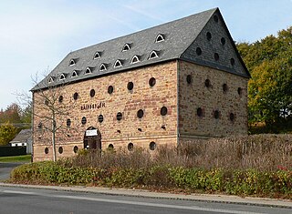
Blanchland Abbey at Blanchland, in the English county of Northumberland, was founded as a premonstratensian priory in 1165 by Walter de Bolbec II, and was a daughter house of Croxton Abbey in Leicestershire. It became an abbey in the late 13th century. The 16th century former Abbot's house is a Grade II* listed building and the whole site is a Scheduled Ancient Monument.

Slaley is a village in Northumberland, England. It is situated to the southeast of Hexham. It is surrounded by the following villages: Ruffside, Whitley Chapel, Ordley, Wooley, Healey, Juniper, Riding Lea, and Blanchland.
Hartlepool Abbey, also known as Heretu Abbey, Hereteu Abbey, Heorthu Abbey or Herutey Abbey, was a Northumbrian monastery founded in 640 CE by Hieu, the first of the saintly recluses of Northumbria, and Aidan of Lindisfarne, on the Headland Estate of Hartlepool now called the Heugh or Old Hartlepool, in County Durham, England.

Hexhamshire Moors is a Site of Special Scientific Interest covering an extensive area of moorland in the Wear Valley district of north-west County Durham and the Tynedale district of south-west Northumberland, England.

Pow Hill Bog is a Site of Special Scientific Interest in the Wear Valley district of County Durham, England. It lies alongside Derwent Reservoir, approximately 2 km north-west of the village of Edmundbyers and adjacent to the Edmundbyers Common portion of the Muggleswick, Stanhope and Edmundbyers Commons and Blanchland Moor SSSI.

Various monasteries and other religious houses have existed at various times during the Middle Ages in the city of Exeter, Devon, England.

The Abbey Church of Saint Peter and Saint Paul, Monkwearmouth–Jarrow, known simply as Monkwearmouth–Jarrow Abbey, was a Benedictine double monastery in the Kingdom of Northumbria, England.
William Henry Knowles RIBA, FSA, FSAScot was an architect, antiquarian and archaeologist. He was born in Newcastle upon Tyne, Northumberland and died in Malvern, Worcestershire. He designed many buildings in Newcastle upon Tyne and directed several archaeological excavations, most notably the excavations at Corstopium (Corbridge).


