Broughton is a town and civil parish situated on the Roman Ermine Street, in the North Lincolnshire district of Lincolnshire, England. The population of the civil parish at the 2011 census was 5,726. In 2021, the population was 5,434. It is situated approximately 2 miles (3 km) north-west from the town of Brigg. The hamlets of Wressle, Castlethorpe, and part of Scawby Brook lie within the parish boundaries.

South Creake is a village and civil parish in north west Norfolk, England. The village lies 1+1⁄2 miles (2.4 km) south of its twin village of North Creake, and some 5 miles (8 km) north-west of the town of Fakenham.

Lamesley is a village and civil parish in the Metropolitan Borough of Durham, Tyne and Wear, England. The population of the civil parish at the 2011 census was 3,742. The village is on the southern outskirts of Gateshead, near to Birtley. The parish includes Kibblesworth, Lamesley village, Eighton Banks and Northside, Birtley which is predominantly private housing in neighbourhoods named The Hollys, Long Bank, Northdene and Crathie. The ruined Ravensworth Castle is also in Lamesley.

Ashby with Scremby is a civil parish in the East Lindsey district of Lincolnshire, England, with a population of 147, increasing to 179 at the 2011 census. The parish includes the village of Scremby, along with the hamlets of Ashby by Partney and Grebby.

Austerson is a civil parish in the unitary authority of Cheshire East and the ceremonial county of Cheshire, England, lying immediately south of the town of Nantwich and north of the village of Audlem. Predominantly rural with scattered farms, the civil parish includes the small settlement of Old Hall Austerson at SJ656493, about two miles south of Nantwich centre. In 2001, the total population was a little under 150, increasing to 194 at the 2011 Census. Nearby villages include Broomhall Green, Hack Green, Hankelow, Sound Heath and Stapeley.

Barton is a village and civil parish in the unitary authority of Cheshire West and Chester and the ceremonial county of Cheshire, England. The village is located near the Welsh border, about twelve miles south of Chester and only about eight miles east of Wrexham in Wales.

Sculthorpe is a village and civil parish in the English county of Norfolk. The village is some 4 km (2.5 mi) north-west of Fakenham and 5 km (3.1 mi) south-east of South Creake.

Buckland is a village and civil parish in the East Hertfordshire district of Hertfordshire, England. The village is situated on the A10 road, with the market town of Royston situated 41⁄2 miles north and Buntingford 3 miles south. According to the 2011 census, the parish of Buckland, including the hamlet of Chipping has a population of 274.

Yelverton is a village and civil parish in the English county of Norfolk, situated some 5 miles (8.0 km) south east of Norwich and closely associated with Alpington.
Linchmere, also spelled Lynchmere, is a village and a civil parish, the northernmost parish in the Chichester district of West Sussex, England. It is between Haslemere and Liphook, south of the B2131 road. As well as Linchmere village, the parish contains the settlements of Hammer and Camelsdale.

South Thoresby is a village and civil parish in the East Lindsey district of Lincolnshire, England. It is situated 10 miles (16 km) north-east from Horncastle and 8 miles (13 km) south-east from Louth. Its population was 128 in 2011.

Chorley is a hamlet and civil parish in the unitary authority of Cheshire East and the ceremonial county of Cheshire, England. The hamlet lies 5 miles to the west of Nantwich and 6 miles to the north east of Malpas. The total population is a little over a hundred people. Nearby villages include Faddiley, Norbury, Ravensmoor and Wrenbury.

Leighton is a scattered settlement and civil parish in the unitary authority of Cheshire East and the ceremonial county of Cheshire, England, which lies immediately north west of Crewe. The parish also includes the village of Barrows Green, which lies on the northern outskirts of Crewe, 1½ miles from the centre. Nearby villages include Bradfield Green and Worleston. The total population of the civil parish was 4,883 at the 2011 Census.

Rope is a scattered settlement and civil parish in the unitary authority of Cheshire East and the ceremonial county of Cheshire, England. It lies immediately to the south of Crewe, with the centre of the parish being around 2¼ miles from the centre of Crewe. Nearby villages include Shavington, Willaston and Wistaston. The civil parish has a total population of just over 2150, reducing to 2,034 at the 2011 Census.

Weston is a village and former civil parish, now in the parish of Weston and Crewe Green, in the unitary authority area of Cheshire East and the ceremonial county of Cheshire, England. The village lies 3 miles to the south east of Crewe. The parish also includes the small settlements of Carters Green, Gorstyhill, Rose Hill, Snape, Stowford and part of Englesea Brook, as well as the new settlements of Wychwood Park and Wychwood Village. Plans in 2015 to develop a golf course surrounding Wychwood Village for residential housing have been opposed by some residents. The plans were refused planning permission by Cheshire East Council; the developer was later unsuccessful in an appeal to the Secretary of State and the council's refusal was upheld. Nearby villages include Basford, Hough and Shavington. In 2011 the parish had a population of 1,855.

Withern is a village in the civil parish of Withern with Stain, in the East Lindsey district of Lincolnshire, England. It is situated on the A157 road, and 7 miles (11 km) south-east from Louth. Stain was once an independent parish but was combined with Withern when the old church of St John the Baptist was destroyed some centuries ago.

Chowley is a hamlet and civil parish in the Borough of Cheshire West and Chester and the ceremonial county of Cheshire, England. It is approximately 9.5 miles (15.3 km) south east of Chester and about 1.3 miles (2.1 km) south west of Tattenhall.

South Somercotes is a village and civil parish 8 miles (13 km) north-east from Louth and approximately 2 miles (3.2 km) south from North Somercotes, Lincolnshire, England. The civil parish includes the hamlet of Scupholme.
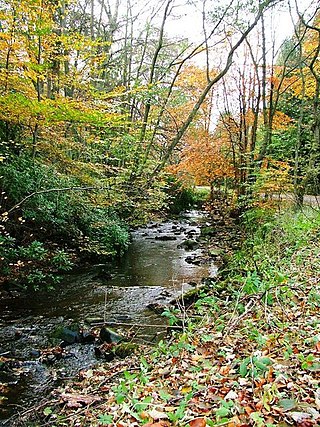
Bedburn Beck is a 16.8 kilometres (10.4 mi) long, upper tributary of the River Wear in County Durham, England. The beck and its tributaries, including the Euden, Harthorpe and South Grain becks, have a catchment of 76 square kilometres (29 sq mi), much of which is covered by the coniferous Hamsterley Forest.
