Aislaby is a small village and civil parish on the north bank of the River Tees within the borough of Stockton-on-Tees and the ceremonial county of County Durham, England. It is located to the west of Eaglescliffe and Yarm. The name, first attested as Asulue(s)bi in 1086, is of Viking origin and means "Aslak's farm." Aislaby was listed in the Domesday Book of 1086.
Killerby is a village in the borough of Darlington and the ceremonial county of County Durham, England. It is situated a few miles to the west of Darlington. Details are maintained in the parish of Staindrop.

Barmpton is a small village and civil parish in the borough of Darlington and the ceremonial county of County Durham, England. The population taken at the 2011 Census was less than 100. Details are maintained in the parish of Great Burdon. It is situated a short distance to the north-east of Darlington, on the River Skerne, a tributary of the Tees.

Beaumont Hill is a village in the borough of Darlington and the traditional and ceremonial counties of Durham in England, situated directly to the north of Darlington on the A167 road.

Ingleton is a village and civil parish in County Durham, England. The population of the parish as taken at the 2011 census was 420. It is situated about eight miles to the west of Darlington, and a short distance from the villages of Langton, Hilton and Killerby. The Church of St John the Evangelist in Ingleton was built in 1843 by Ignatius Bonomi and J.A. Cory., and is a Grade II listed building.
High Hesleden is a village in Monk Hesleden parish, County Durham, in England. It is situated a few miles north of Hartlepool, between Blackhall Rocks and Hesleden.
Houghton Bank is a village in the borough of Darlington and the ceremonial county of County Durham, England. It is situated a few miles west of Newton Aycliffe, on the A68 between Darlington and Bishop Auckland.

Houghton-le-Side is a small village in the borough of Darlington and the ceremonial county of County Durham, England. It is situated a few miles to the south-west of Newton Aycliffe.
Hummersknott is an area in the western end of Darlington, County Durham England. It is a ward in the unitary authority of Darlington. It consists of mainly post-war houses, and is closely linked to Mowden. The population of the ward taken at the 2011 Census was 3,478.
Monk Hesleden is a village and civil parish in County Durham, England. The population of the parish at the 2011 Census was 5,722. The parish is situated to the north-west of Hartlepool, and is on the North Sea coast. Monk Hesleden village is situated a short distance to the south of High Hesleden.
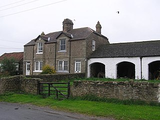
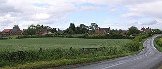
Morton Tinmouth is a hamlet of a few farms in County Durham, England. It is situated a few miles to the north-west of Darlington close to the village of Bolam.
Little Stainton is a village in the borough of Darlington and the ceremonial county of County Durham, England. It is a township in the parish of Bishopton, County Durham, situated a few miles west of Stockton-on-Tees. It is a hamlet, consisting of houses and farms that have no local service facilities. On one side of the street, a stream—Bishopton Beck—runs along the bottom of the gardens.
Great Burdon is a village in the borough of Darlington and the ceremonial county of County Durham, England. It is situated to the north-east of Darlington.

Headlam is a village in the borough of Darlington and the ceremonial county of County Durham, England. It lies to the west of Darlington. The population taken at the 2011 Census was less than 100. Details are included in the parish of Ingleton. The hamlet has 14 stone houses plus 17th-century Headlam Hall, now a country house hotel. The village is set around a village green with a medieval cattle-pound and an old stone packhorse bridge across the beck. Headlam is classed as Lower Teesdale and has views to the south as far as Richmond and to the Cleveland Hills in the east.

Langbaurgh was a liberty or wapentake of the North Riding of Yorkshire. It covered an area of the shire's north-eastern tip. The wapentake took its name from Langbaurgh hamlet, in present-day Great Ayton parish.
Croxdale and Hett is a civil parish in County Durham, England. It is situated approximately four miles south of Durham. The population of the civil parish as taken at the 2011 census was 866.

The Borough of Darlington is a unitary authority area with borough status in County Durham, England. Since 1997 Darlington Borough Council has been a unitary authority; it is independent from Durham County Council. It is named after its largest settlement, the town of Darlington, where the council is based. The borough also includes a rural area surrounding the town which contains several villages. The population of the borough at the 2021 census was 107,800, of which over 86% (93,015) lived in the built-up area of Darlington itself.
Whinney Hill is a village within the borough of Stockton-on-Tees and the ceremonial county of County Durham, England. Whinney Hill lies 2 miles (3.2 km) west of Stockton-on-Tees.

Dacre Beck is a small river in Cumbria, England.

Cade's Road is a Roman Road in north-east England. It is named after John Cade of Durham, an 18th-century antiquarian who in 1785 proposed its existence and possible course from the Humber Estuary northwards to the River Tyne, a distance of about 100 miles (160 km). The road's Roman name is unknown. Although evidence exists for such a road on some parts of the proposed route, there is still some doubt regarding its exact course.
