Elwick, County Durham

Last updated

Elwick
Village and civil parish
Elwick Village Green - geograph.org.uk - 279035.jpg
The village green
Durham UK location map.svg
Red pog.svg
Elwick
Location within County Durham
Population1,001 (2011) [1]
OS grid reference NZ4619932279
Civil parish
  • Elwick
Unitary authority
Ceremonial county
Region
Country England
Sovereign state United Kingdom
Post town HARTLEPOOL
Postcode district TS27
Dialling code 01429
Police Cleveland
Fire Cleveland
Ambulance North East
UK Parliament
List of places
UK
England
County Durham
54°41′03″N1°17′43″W / 54.6843°N 1.2953°W / 54.6843; -1.2953

Elwick is a village and civil parish in the borough of Hartlepool in County Durham, England. It is situated near the A19 road to the west of Hartlepool. Historically, Elwick was a township until 1866 when it became a civil parish. [2]

Contents

History, population and governance

Mortality decline in the late 19th century was mainly due to the reduction of a very high infant mortality rates. But during the 20th and 21st centuries a decline in fertility rates and an improved life expectancy has changed the age structure of the population. [3] Elwick has been described by John Marius Wilson in historic writings as, "Elwick, a township in Hart parish, Durham; 4 miles W by S of Hartlepool. It has a post office under Ferryhill. Acres, 1, 500. Real property, £1, 418. Pop., 240. Houses, 55. The township is a meet for the Durham hounds." – from the Imperial Gazetteer of England and Wales in 1870–72. [4]

Historical population
YearPop.±%
1801 129    
1811 129+0.0%
1821 176+36.4%
1831 169−4.0%
1841 165−2.4%
1851 187+13.3%
1881 166−11.2%
1891 178+7.2%
1901 258+44.9%
1911 185−28.3%
1921 197+6.5%
1931 204+3.6%
1951 208+2.0%
1961 203−2.4%
[5]     

The population as taken at the 2015 census was 2061. [6]

Elwick is also an electoral ward of Hartlepool since 1974 and is run by a parish council. In May 2021, the parish council alongside the parish councils of the villages of Hart, Dalton Piercy and Greatham all issued individual votes of no confidence in Hartlepool Borough Council, and expressed their desire to re-join County Durham. [7]

Church

Saint Peters church is Church of England and the only church in Elwick. It has been described by the Archbishops' Council as "a small, friendly, family-orientated church." . [8] It is a grade two listed building, listed in 1967. Protected by the English Heritage its ID number is: 59861. The church was built in the late 12th century, but has been restored many times. St Peters has aisled nave, chancel with north vestry and a south-west tower overlooking the porch. [9] The church has beautiful stained glass windows. The church commissioned a window depicting marriage, which was installed in February 2010 and designed by Alan Davis. [10]

Facilities

Elwick has two public houses – The Spotted Cow and the McOrville Inn. It had a village shop and post office until recently, when it closed.

The village shop has been subsequently been refurbished by a local family and reopened as "Coopers of Elwick", not only offering groceries but now also incorporating a tea room. [11]

There is a WI Hall in the Village which is available for events and hire.

Elwick Village also boasts a popular play park and playing field, the James F. Grieves Memorial Playing Field. Managed by the Parish Council and supported by grants, the village has been able to install a good variety of play equipment.

There is a large village green at the centre of the village that is used for events such as the annual Fete and “Gig on The Green”.

A wild life garden is also a nice relaxing feature with wild flowers and a pond.

Education

Primary school

The school in Elwick is St Peters Elwick Primary School [12]

Secondary and further education

For higher education people travel out of the parish into Hartlepool. The linked secondary school is High Tunstall College of Science (Ofsted rated Good) there are 4 other secondary schools in Hartlepool - Dyke House Sports and Technology College, The English Martyrs School and Sixth Form College, Manor Community Academy, and St Hilda's Church of England School. [13] Also for further education there is the Hartlepool College of Further Education and Teesside University. [14]

Transport

The road through Elwick Crossroads, Elwick Road- Hart Back Lane - geograph.org.uk - 24528.jpg
The road through Elwick

A main road runs through the centre of the village called Elwick road, easterly it connects the village to Hartlepool. To the west the road connects to the A19. There is a second exit from North Lane onto the A19

Gaps in the A19 were closed preventing traffic from the village from either accessing from the south, or leaving the village to turn north. This has caused significant additional distance for villagers wanting to leave to the north or enter from the south in the A19.

There are also issues with the increasing amount if traffic using Elwick Road as a rat run to the A19.

Pauls Travel has service 65 bus through the village. [15] Most journeys from Elwick transport people to Hartlepool. The Tees Flex bus service has been running since early 2020. This is an on demand service funded by the Tees Valley Authority.

The nearest airport is Teesside International Airport, which was RAF Middleton St George during World War II. [16] There is no railway station; the nearest to Elwick is either Billingham or Hartlepool. [17]

Industry

Britain in 1801 was divided into two categories of employment – agriculture or trade. [18] Elwick was predominantly agricultural. There are 517 economically active people (aged 16–74) that live in Elwick, 283 of those are in employment and nine are unemployed. [19]

Geography

The wind turbines Wind Turbine, Elwick - geograph.org.uk - 16420.jpg
The wind turbines

Renewable energy

EON, the energy supplier, has put in place three wind turbines on the border of the parish. [20] This development in 2003 split the community, with some accepting the turbines and others opposing them. [21] The three wind turbines provide energy for 6,000 homes. [22]

Climate

With an 8.5 °C to 9.5 °C average temperature, the climate of Elwick is colder than the UK`s average annual temperature of 7 °C to 11 °C. [23]

Urbanisation

English Heritage have listed the disused, six-storey-high, brick Elwick windmill. Built in the mid-19th century and grade two listed on 8 January 1980, this windmill has been protected and preserved as a piece of Elwick's history. [24] Apart from the historic buildings of the windmill and church, the majority of the development is residential housing. [25] Elwick has green spaces and old farm buildings. It is not highly built up, or filled with industrial buildings.

Geology

The landscape is on low-lying land in a valley. The rocks date to the Triassic period (248–205 million years ago). The most common rock type found is red sandstone and mudstone that was deposited under arid sea conditions, with younger Permian period rock overlaid. [26]

Resources

Elwick's main resource is its fertile land, with many farms near by; and a windy climate supporting its wind turbines to produce electricity.

Notable people

Related Research Articles

<span class="mw-page-title-main">Yarm</span> Town and civil parish in North Yorkshire, England

Yarm, also referred to as Yarm-on-Tees, is a market town and civil parish in the Borough of Stockton-on-Tees, North Yorkshire, England. It is in Teesdale with a town centre on a small meander of the River Tees. To the south-east, it extends to the River Leven, to the south it extends into the Kirklevington.

<span class="mw-page-title-main">Hartlepool</span> Town in County Durham, England

Hartlepool is a seaside and port town in County Durham, England. It is governed by a unitary authority borough named after the town. The borough is part of the devolved Tees Valley area. With an estimated population of 87,995, it is the second-largest settlement in County Durham.

<span class="mw-page-title-main">Stockton-on-Tees</span> Town in County Durham, England

Stockton-on-Tees is a market town in County Durham, England, with a population of 84,815 at the 2021 UK census. It is part of Teesside and the Tees Valley, on the northern bank of the River Tees.

<span class="mw-page-title-main">Middlesbrough</span> Town in North Yorkshire, England

Middlesbrough is a town in the Middlesbrough unitary authority borough of North Yorkshire, England. The town lies near the mouth of the River Tees and north of the North York Moors National Park. The built-up area had a population of 148,215 at the 2021 UK census. It is the largest town of the wider Teesside area, which had a population of 376,633 in 2011.

<span class="mw-page-title-main">County Durham</span> County of England

County Durham, officially simply Durham (/ˈdʌrəm/), is a ceremonial county in North East England. The county borders Northumberland and Tyne and Wear to the north, the North Sea to the east, North Yorkshire to the south, and Cumbria to the west. The largest settlement is Darlington, and the county town is the city of Durham.

<span class="mw-page-title-main">Thornaby-on-Tees</span> Town and civil parish in North Yorkshire, England

Thornaby-on-Tees, commonly referred to as Thornaby, is a town and civil parish on the River Tees's southern bank. It is in the Borough of Stockton-on-Tees, North Yorkshire, England. The parish had a population of 24,741 at the 2011 census, in the Teesside built-up area.

<span class="mw-page-title-main">A19 road</span> Road in Northern England

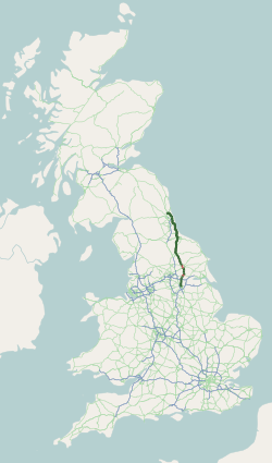
The A19 is a major road in England running approximately parallel to and east of the A1 road. Although the two roads meet at the northern end of the A19, the two roads originally met at the southern end of the A19 in Doncaster, but the old route of the A1 was changed to the A638. From Sunderland northwards, the route was formerly the A108. In the past the route was known as the East of Snaith-York-Thirsk-Stockton-on-Tees-Sunderland Trunk Road. Most traffic joins the A19, heading for Teesside, from the A168 at Dishforth Interchange.

<span class="mw-page-title-main">Billingham</span> Town in County Durham, England

Billingham is a town and civil parish in County Durham, England. The town is on the north side of the River Tees and is governed as part of the Borough of Stockton-on-Tees unitary authority. It had a population of 35,165 in the 2011 Census.

<span class="mw-page-title-main">Tees Valley</span> Mayoral combined authority area in North East England

The Tees Valley is a combined authority area in North East England, around the lower River Tees. The area is not a geographical valley; the local term for the valley is Teesdale. The combined authority covers five council areas: Darlington, Hartlepool, Middlesbrough, Redcar and Cleveland and Stockton-on-Tees.

<span class="mw-page-title-main">Bishopton, County Durham</span> Human settlement in England

Bishopton is a village in the borough of Darlington and the ceremonial county of County Durham, England. It is situated to the west of Stockton-on-Tees. It originated as a farming community with rows of cottages and several farms forming a long wide village street, with an adjacent green. St Peter's Church stands at the centre of the village. The hamlet of Little Stainton and the village of Great Stainton were formerly part of the parish of Bishopton.

<span class="mw-page-title-main">Dalton Piercy</span> Village in County Durham, England

Dalton Piercy is a village and civil parish in the borough of Hartlepool, County Durham, in England. The population of the civil parish taken at the 2011 Cernsus was 289.

<span class="mw-page-title-main">Piercebridge</span> Human settlement in England

Piercebridge is a village and civil parish in the borough of Darlington and the ceremonial county of Durham, England. The population of the civil parish as of the 2011 census was 113. It is situated a few miles west of the town of Darlington. It is on the site of a Roman fort of AD 260–270, which was built at the point where Dere Street crossed the River Tees. Part of the fort is under the village green. The village is sited where the York-Newstead Roman road known as Dere Street crosses the River Tees.

<span class="mw-page-title-main">Egglescliffe</span> Village and civil parish in County Durham, England

Egglescliffe is a village and civil parish in County Durham, England. Administratively it is located in the borough of Stockton-on-Tees.

<span class="mw-page-title-main">Hart, County Durham</span> Human settlement in England

Hart is a village and civil parish in County Durham, England, northwest of Hartlepool.

<span class="mw-page-title-main">Stillington, County Durham</span> Village in County Durham, England

Stillington is a village and former civil parish, now in the parish of Stillington and Whitton, in the Stockton-on-Tees district, in the ceremonial county of Durham, England, northwest of Stockton-on-Tees.

<span class="mw-page-title-main">Borough of Hartlepool</span> Unitary authority area in County Durham, England

The Borough of Hartlepool is a unitary authority area in ceremonial County Durham, England. The borough's largest town is Hartlepool.

<span class="mw-page-title-main">Greatham, County Durham</span> Village and civil parish in Hartlepool, County Durham, England

Greatham is a village and civil parish in the borough of Hartlepool, County Durham, England. The population of the civil parish was taken in the 2011 census was 2,132. Greatham village is located approximately three miles south of Hartlepool town centre.

The High Sheriff of Cleveland was a High Sheriff title which was in existence from 1974 until 1996, covering Cleveland, England.

<span class="mw-page-title-main">County Durham (district)</span> Unitary authority area in England

County Durham is a local government district in North East England. It is governed by Durham County Council, a unitary authority. The district has an area of 2,232.6 km2, and contains 135 civil parishes. It forms part of the larger ceremonial county of Durham, together with boroughs of Darlington, Hartlepool, and the part of Stockton-on-Tees north of the River Tees.

References

  1. "Parish population 2011". Archived from the original on 4 March 2016. Retrieved 22 July 2015.
  2. "unit history and boundary changes". humphrey southall. Archived from the original on 19 September 2012. Retrieved 15 March 2012.
  3. "Elwick through time" . Retrieved 13 March 2012.
  4. "historical writings of Elwick". John Marius Wilson. Retrieved 13 March 2012.[ permanent dead link ]
  5. "historical population and statistics". Humphrey Southall. Retrieved 23 March 2012.
  6. "Hartlepool Ward population 2011" . Retrieved 22 July 2015.
  7. Nic Marko (10 May 2021), Four Hartlepool villages have 'no confidence' in borough council and want to join Durham, Hartlepool: Hartlepool Mail
  8. "The Church of England". Archbishops' council. Retrieved 20 March 2012.
  9. "British Listed Buildings". english heritage. Retrieved 16 March 2012.
  10. "The Church of England". Archbishops' council. Retrieved 20 March 2012.
  11. "Village tea room is now open for business on the outskirts of Hartlepool".
  12. "schools mission statement". Archived from the original on 31 December 2012. Retrieved 19 April 2012.
  13. Secondary Schools – Hartlepool Borough Council Archived 18 May 2007 at the Wayback Machine
  14. "Big maps". UCAS. Retrieved 24 April 2012.
  15. "Connect Tees valley". Tess valley unlimited. Archived from the original on 8 March 2012. Retrieved 26 March 2012.
  16. "tees valley airport". unknown. Archived from the original on 8 May 2012. Retrieved 14 April 2012.
  17. "station finder". the train line. Retrieved 23 March 2012.
  18. "historical statistics on industry". humphrey southall. Retrieved 30 May 2012.
  19. "work and qualifications". neighbourhood statistics. Retrieved 24 April 2012.
  20. "wind farm development". Phil Wilson. Retrieved 4 May 2012.
  21. "wind turbines". BBC. Retrieved 26 May 2012.
  22. "wind turbines". BBC. Retrieved 26 May 2012.
  23. "climate". met office. Archived from the original on 5 November 2013. Retrieved 13 March 2004.
  24. "Elwick windmill". english heritage. Retrieved 19 March 2012.
  25. "properties in Elwick". right move. Retrieved 28 April 2012.
  26. "Natural England". natural england. Archived from the original on 14 October 2013. Retrieved 28 April 2012.