Cockfield, County Durham

Last updated

Cockfield
Church of St Mary the Virgin, Cockfield, County Durham.jpg
St Mary the Virgin church, Cockfield
Durham UK location map.svg
Red pog.svg
Cockfield
Location within County Durham
Population1,531 (2011) [1]
OS grid reference NZ126242
Unitary authority
Ceremonial county
Region
Country England
Sovereign state United Kingdom
Post town Bishop Auckland
Postcode district DL13
Dialling code 01388
Police Durham
Fire County Durham and Darlington
Ambulance North East
UK Parliament
List of places
UK
England
County Durham
54°36′47″N1°48′22″W / 54.61292°N 1.80616°W / 54.61292; -1.80616

Cockfield is a village on the edge of Teesdale, County Durham, England. It is situated 8 miles to the south-west of Bishop Auckland, 15 miles (24 km) north-west of Darlington and 40 miles (64 km) south-west of Newcastle upon Tyne. Remains found on Cockfield Fell suggest there was a settlement in the area during the Iron Age. The parish church, dedicated to St Mary the Virgin, probably dates from the late 12th century.

Contents

Coal mining began in the area in the medieval period. When the South West Durham coalfield was opened in the 19th and 20th centuries the population of the village grew significantly. The last coal mine closed in 1962.

Notable residents

One of the more illustrious families to hail from Cockfield was the Martindale family.

George Dixon (1731–1785) George Dixon was someone who owned coal mines and was a keen inventor, he was probably the first to use coal gas for illumination. [2] George Dixon died in Cockfield on 29 September 1785 at the age of 53

Jeremiah Dixon (1733–1779) the brother of George Dixon, Jeremiah Dixon was an astronomer, went to America with Charles Mason in 1763 to survey the boundaries of Maryland and Pennsylvania thereby creating the 'Mason–Dixon line'. Jeremiah Dixon died unmarried in Cockfield on 22 January 1779 at the age of 45

Local amenities

Public houses

There are three public houses in the village, the Queen's Head, the King's Head, and the Cockfield Working Men's Club.

Stores

There are three stores in the village of Cockfield, a Co-operative, newsagents, and also a general store, which incorporates as coffee shop. The village also has a Pharmacy, which also contains the Post Office.

Schools

The local primary school is Cockfield County Primary School.

Churches

The two churches that can be found in Cockfield are the CofE Church of Saint Mary the Virgin and the Cockfield Methodist Church.

Transport

Whilst Cockfield once had a railway, this was closed to passengers in 1958, before its complete closure in 1962. [3] [ circular reference ] It is now served by bus services from Arriva North East and Scarlet Band with links to Darlington, Bishop Auckland, Barnard Castle, Durham (number 6) and the retail park at Tindale crescent.

Cockfield Fell

Cockfield Fell is described as "one of the most important early industrial landscapes in Britain". In addition to four Iron Age (or Romano-British) settlement enclosures, there is evidence within the landscape of early coal mines (the Bishop of Durham licensed mining here at least as early as 1303), medieval agricultural field patterns, centuries of quarrying activity, a railway line established in the 1830s and several earlier tramways. [4] All together, Cockfield Fell constitutes England's largest Scheduled Ancient Monument, described as 'an incomparable association of field monuments relating to the Iron settlement history and industrial evolution of a northern English County'. One reason for its preservation - unusual for a lowland fell - is that it was not subject to enclosure in the 18th or 19th century, perhaps due to its highly industrialised past. [5]

Related Research Articles

<span class="mw-page-title-main">Jeremiah Dixon</span> British astronomer and surveyor (1733–1779)

Jeremiah Dixon was an English surveyor and astronomer who is best known for his work with Charles Mason, from 1763 to 1767, in determining what was later called the Mason–Dixon line.

<span class="mw-page-title-main">Stockton and Darlington Railway</span> English railway company, 1825 to 1863

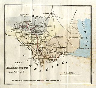
The Stockton and Darlington Railway (S&DR) was a railway company that operated in north-east England from 1825 to 1863. The world's first public railway to use steam locomotives, its first line connected collieries near Shildon with Darlington and Stockton in County Durham, and was officially opened on 27 September 1825. The movement of coal to ships rapidly became a lucrative business, and the line was soon extended to a new port at Middlesbrough. While coal waggons were hauled by steam locomotives from the start, passengers were carried in coaches drawn by horses until carriages hauled by steam locomotives were introduced in 1833.

<span class="mw-page-title-main">Bishop Auckland</span> Town and civil parish in County Durham, England

Bishop Auckland is a market town and civil parish at the confluence of the River Wear and the River Gaunless in County Durham, England. It is 12 miles (19 km) northwest of Darlington and 12 miles (19 km) southwest of Durham.

<span class="mw-page-title-main">County Durham</span> County of England

County Durham, officially simply Durham (/ˈdʌrəm/), is a ceremonial county in North East England. The county borders Northumberland and Tyne and Wear to the north, the North Sea to the east, North Yorkshire to the south, and Cumbria to the west. The largest settlement is Darlington, and the county town is the city of Durham.

<span class="mw-page-title-main">Spennymoor</span> Town and civil parish in England

Spennymoor is a town and civil parish in County Durham, England. It is south of the River Wear and is 7 mi (11 km) south of Durham. The civil parish includes the villages of Kirk Merrington, Middlestone Moor, Byers Green and Tudhoe.

<span class="mw-page-title-main">Weardale Railway</span> Heritage railway in County Durham, England

The Weardale Railway is an independently owned British single-track branch line heritage railway between Bishop Auckland, Witton-le-Wear, Wolsingham, Frosterley and Stanhope. Weardale Railway began services on 23 May 2010, but decided to run special trains rather than a scheduled service for the 2013 season. The line was purchased by the Auckland Project in 2020 with a view to restarting passenger services. In 2021, a bid was submitted to the Restoring Your Railway fund. In October 2021, the Department for Transport allocated funding for the development of a business case.

<span class="mw-page-title-main">History of County Durham</span>

The history of County Durham.

<span class="mw-page-title-main">Butterknowle</span> Human settlement in England

Butterknowle is a village in Teesdale, County Durham, England. Butterknowle is situated between the market towns of Bishop Auckland and Barnard Castle. It has an attractive rural setting within the Gaunless Valley, overlooked by the gorse-covered Cockfield Fell. The fell itself is a scheduled ancient monument, containing evidence of Roman settlements and a medieval coal mine (Vavasours), thought to be the earliest inland colliery recorded.

<span class="mw-page-title-main">Staindrop</span> Village in County Durham, England

Staindrop is a village and civil parish in County Durham, England. It is situated approximately 6 miles (9.7 km) north east of Barnard Castle, on the A688 road. According to the 2011 UK census the population was 1,310, this includes the hamlets of Cleatlam and Killerby.

<span class="mw-page-title-main">Shildon</span> Town and civil parish in County Durham, England

Shildon is a town and civil parish in County Durham, in England. The population taken at the 2011 Census was 9,976. The town has the Locomotion Museum, due to it having the first station, built in 1825, and locomotive works on the Stockton and Darlington Railway.

<span class="mw-page-title-main">Witton-le-Wear</span> Human settlement in England

Witton-le-Wear is a village in County Durham, North East England. It is situated on the north bank of the River Wear, 6 km (3.7 mi) to the north-west of Bishop Auckland.

<span class="mw-page-title-main">Weardale</span> Open valley in County Durham, England

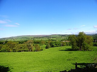
Weardale is a dale, or valley, on the east side of the Pennines in County Durham, England. Large parts of Weardale fall within the North Pennines Area of Outstanding Natural Beauty (AONB) – the second-largest AONB in England and Wales. The upper dale is surrounded by high fells and heather grouse moors. The River Wear flows through Weardale before reaching Bishop Auckland and then Durham, meeting the sea at Sunderland.

<span class="mw-page-title-main">West Auckland, County Durham</span> Village in County Durham, England

West Auckland is a village and civil parish in County Durham, England, to the west of Bishop Auckland on the A688 road. It is reputed to have one of the largest village greens in the country, lined with 17th- and 18th-century buildings.

<span class="mw-page-title-main">Escomb</span> Village in England

Escomb is a village and former civil parish on the River Wear about 1+12 miles (2.4 km) west of Bishop Auckland, in the County Durham district, in the ceremonial county of Durham, England. In 2001 it had a population of 358. In 2011 the ward had a population of 3323.

<span class="mw-page-title-main">Bishop Auckland (UK Parliament constituency)</span> UK Parliament constituency in England since 1885

Bishop Auckland is a constituency in County Durham represented in the House of Commons of the UK Parliament since 2019 by Dehenna Davison, a Conservative.

<span class="mw-page-title-main">Dinsdale railway station</span> Railway station in County Durham, England

Dinsdale is a railway station on the Tees Valley Line, which runs between Bishop Auckland and Saltburn via Darlington. The station, situated 3 miles 65 chains (6.1 km) east of Darlington, serves the village of Middleton St George, Darlington in County Durham, England. It is owned by Network Rail and managed by Northern Trains.

<span class="mw-page-title-main">George Dixon (Cockfield Canal)</span>

George Robertus Dixon, was a chemist, mathematician, engraver, china-painter, engineer, geologist and coal mine operator, who helped pioneer the use of coal gas in heating and gas lighting - one of his gas experiments leading to the destruction of his own house.

Witton Park Colliery was a coal mine in Witton Park, Witton-le-Wear near Bishop Auckland, County Durham, Northern England.

<span class="mw-page-title-main">Durham to Bishop Auckland Line</span> Railway line in County Durham, England

The Durham to Bishop Auckland Line was a railway line originally built by the North Eastern Railway (NER) to provide rail transport access to coal mines in West County Durham. It closed under the Beeching Axe to passenger traffic in May 1964, and freight in 1968. Today it forms the major part of the 9 miles (14 km) Brandon to Bishop Auckland rail trail.

References

  1. "Parish population 2011" . Retrieved 9 July 2015.
  2. "From star-gazing to canal digging". The Northern Echo . Newsquest Media Group . Retrieved 11 March 2010.
  3. Cockfield Fell railway station
  4. Pevsner, Buildings of England: County Durham, Penguin 1983h.
  5. Guy & Atkinson, West Durham: the archaeology of industry, Phillimore 2008

Commons-logo.svg Media related to Cockfield, County Durham at Wikimedia Commons