
Hartlepool is a seaside and port town in County Durham, England. It is governed by a unitary authority borough named after the town. The borough is part of the devolved Tees Valley area. With an estimated population of 92,600, it is the second-largest settlement in County Durham, after Darlington.

West Hartlepool was a predecessor of Hartlepool, County Durham, England. It developed in the Victorian era and took the name from its western position in the parish of what is now known as the Headland.

Dalton Piercy is a village and civil parish in the borough of Hartlepool, County Durham, in England. The population of the civil parish taken at the 2011 Cernsus was 289.
Owton is an area of south-western Hartlepool in the Borough of Hartlepool, County Durham, England. It is served by three shopping precincts, which include St. Patrick's shops, Wynyard Road shops and Owton Manor Lane shops. It is near the area of Rift House, village of Greatham and less than 2 miles away from Seaton Carew.

Houghton Bank is a hamlet in civil parishes of Houghton Le Side and Heighington, in the borough of Darlington and the ceremonial county of County Durham, England. It is situated a few miles west of Newton Aycliffe, on the A68 between Darlington and Bishop Auckland.
Monk Hesleden is a village and civil parish in County Durham, England. The population of the parish at the 2011 Census was 5,722. The parish is situated to the north-west of Hartlepool, and is on the North Sea coast. Monk Hesleden village is situated a short distance to the south of High Hesleden.

Hart is a village and civil parish in County Durham, England, northwest of Hartlepool.

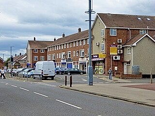
Rift House is an area of south-west Hartlepool in the borough of Hartlepool, County Durham, England. It has a secondary school with a sixth-form college and two primary schools; English Martyrs, Kingsley and Rift House. It was a ward of the town for the 2011 UK Census, for the 2015 UK general election it was split between two wards Manor House and Foggy Furze.

The Borough of Hartlepool is a unitary authority area with borough status in County Durham, England. Hartlepool Borough Council became a unitary authority in 1996; it is independent from Durham County Council. It is named after its largest settlement, Hartlepool, where the council is based. The borough also includes a rural area to the west of the town. The population of the borough at the 2021 census was 92,571, of which over 95% (87,995) lived in the built-up area of Hartlepool itself.

Hutton Bonville is a hamlet and civil parish in the Hambleton District of North Yorkshire, England. The population of the civil parish as of the 2011 census was less than 100. Details are included in the civil parish of Danby Wiske with Lazenby. It is on its own road and near the A167, 6 miles (9.7 km) north of Northallerton.

West Hartlepool Rugby Football Club is an English rugby union club who play in Regional 2 North in the sixth tier of the English rugby union system.

Manor Community Academy is a secondary school in the Owton Manor area of Hartlepool, County Durham. It is an academy school which caters for students aged 11 to 16. It is part of the Northern Education Trust. The school has approximately 1218 students.

Foy is a hamlet and civil parish in Herefordshire, England. By road, it is 7 kilometres north of Ross-on-Wye, 23 kilometres south east of Hereford and 27 kilometres south west of Ledbury. Foy, and the further Foy parish hamlet of Ingestone, lies in a loop of the River Wye with the nearest vehicle bridges at Ross and Hoarwithy.
John Robert Borthwick is an English former professional footballer who made 225 appearances in the Football League playing as a forward for Hartlepool United, Darlington and York City.

The 2012 Hartlepool Borough Council election took place on 3 May 2012 to elect members of Hartlepool Borough Council. There were a number of differences in the composition of constituencies from the 2011 elections, including the absence of the Bruns, Dyke House, Grange, Greatham, Owton, Park, Rift House, Rossmere, St. Hilda, Stranton, and Throston wards. While the 2011 election had 15 available seats, the 2012 election had 36. Burn Valley, Foggy Furze, Hart, and Seaton wards each had two more seats than the previous year, and De Bruce, Fens & Rossmere, Headland & Harbour, Jesmond, Manor House, Rural West, and Victoria, which did not appear in 2011, all held three seats. The Labour Party once again dominated the election.

Stranton is an area of south Hartlepool in the borough of Hartlepool, County Durham, England. It is a former village and parish.
