
Aislaby is a small village and civil parish on the north bank of the River Tees within the borough of Stockton-on-Tees and the ceremonial county of County Durham, England. It is located to the west of Eaglescliffe and Yarm.
Cleatlam is a small village and civil parish in County Durham, England. It lies south of the larger village of Staindrop. It lies approximately 11 miles (18 km) west of Darlington, which is its post town.

Bolam is a small village located in County Durham, England. The parish population at the 2011 census was 209, in 2021 the parish of Bolam alone had 84. It is situated a few miles to the north-west of Darlington.

Staindrop is a village and civil parish in County Durham, England. It is situated approximately 6 miles (9.7 km) north east of Barnard Castle, on the A688 road. According to the 2011 UK census the population was 1,310, this includes the hamlets of Cleatlam and Killerby.

Barmpton is a small village and civil parish in the borough of Darlington and the ceremonial county of County Durham, England. The population taken at the 2011 Census was less than 100. Details are maintained in the parish of Great Burdon. It is situated a short distance to the north-east of Darlington, on the River Skerne, a tributary of the Tees.

Brafferton is a village and civil parish in County Durham, England. It is administered as part of the borough of Darlington. The population of Brafferton Parish taken at the 2011 census was 154. It is situated between Darlington and Newton Aycliffe, a short distance from Coatham Mundeville.

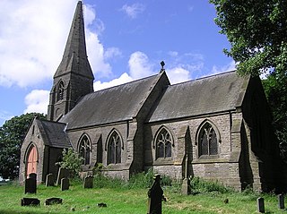
Ingleton is a village and civil parish in County Durham, England. The population of the parish as taken at the 2011 census was 420. It is situated about eight miles to the west of Darlington, and a short distance from the villages of Langton, Hilton and Killerby. The Church of St John the Evangelist in Ingleton was built in 1843 by Ignatius Bonomi and J.A. Cory., and is a Grade II listed building.

Piercebridge is a village and civil parish in the borough of Darlington and the ceremonial county of Durham, England. It is situated a few miles west of the town of Darlington. It is on the site of a Roman fort of AD 260–270, which was built at the point where Dere Street crossed the River Tees. Part of the fort is under the village green. The village is sited where the York-Newstead Roman road known as Dere Street crosses the River Tees.

Cockerton is an area in the north-west of Darlington in the borough of Darlington, County Durham, England. The Cocker Beck flows through the area and empties into the River Skerne via The Denes, an area and string of valleyed parks donated for the town in the early 20th century. It is also near Mowden, Branksome, West Park and Faverdale.

Houghton-le-Side is a small village in the borough of Darlington and the ceremonial county of County Durham, England. It is situated a few miles to the south-west of Newton Aycliffe.

Mainsforth is a small village and former civil parish, now in the parish of Bishop Middleham, in the County Durham district, in the ceremonial county of Durham, England. It is to the east of Ferryhill. The earliest settlement in Mainsforth may have been on Marble. It has been suggested, without great historical foundation, that this was a Danish settlement. In 1961 the parish had a population of 229. From medieval times through to the early twentieth century the village was in effect a small collection of farms and farm workers' cottages.
Mordon is a village and civil parish in County Durham, England. It is situated a few miles to the north-east of Newton Aycliffe. The population recorded by the 2011 census for the parish was 260.
Morton Tinmouth is a hamlet of a few farms in County Durham, England. It is situated a few miles to the north-west of Darlington close to the village of Bolam. In 2021 the parish had a population of 14.
Great Stainton is a village in the borough of Darlington and ceremonial county of County Durham, England. It is situated to the north of Darlington, and to the west of Stockton-on-Tees. Elstob is a hamlet, just north of Great Stainton, which is part of the Parish of Great Stainton. The population as taken at the Census 2011 was less than 100. Details are now maintained in the parish of Little Stainton.

Headlam is a hamlet and civil parish in County Durham, England. It lies to the west of Darlington. In 2021 the parish had a population of 41. The hamlet has 14 stone houses plus 17th-century Headlam Hall, now a country house hotel. The village is set around a village green with a medieval cattle-pound and an old stone packhorse bridge across the beck. Headlam is classed as Lower Teesdale and has views to the south as far as Richmond and to the Cleveland Hills in the east.

Neasham is a village approximately four miles to the south east of Darlington in County Durham, England.

Lanchester is a village and civil parish in County Durham, England, 8 miles (13 km) west of Durham and 5 miles (8 km) from Consett. It had a population at the 2011 Census of 4,054.
Croxdale and Hett is a civil parish in County Durham, England. It is situated approximately four miles south of Durham. The population of the civil parish as taken at the 2011 census was 866.

The Borough of Darlington is a unitary authority area with borough status in County Durham, England. Since 1997 Darlington Borough Council has been a unitary authority; it is independent from Durham County Council. It is named after its largest settlement, the town of Darlington, where the council is based. The borough also includes a rural area surrounding the town which contains several villages. The population of the borough at the 2021 census was 107,800, of which over 86% (93,015) lived in the built-up area of Darlington itself.

Hornby is a village and civil parish in the former Hambleton District of North Yorkshire, England. It lies on a minor road between Great Smeaton and Appleton Wiske.

