
The North Pennines is the northernmost section of the Pennine range of hills which runs north–south through northern England. It lies between Carlisle to the west and Darlington to the east, straddling the borders of the counties of Cumbria, Durham, Northumberland and North Yorkshire. It is bounded to the north by the Tyne Valley and to the south by the Stainmore Gap.

Teesdale is a dale, or valley, located principally in County Durham, North East England. It is one of the Durham Dales, which are themselves part of the North Pennines, the northernmost part of the Pennine uplands.

Holwick is a hamlet and civil parish in Teesdale, County Durham (district), England. Located in the Pennine hills, the hamlet consists of a few houses spread along a road in the pattern of a linear settlement. The population of the parish taken at the 2021 Census was 75.

Mickleton is a village and civil parish in Teesdale, County Durham, England, situated 8.5 miles (13.7 km) north west of Barnard Castle. Lying within the historic boundaries of the North Riding of Yorkshire, the village along with the rest of the former Startforth Rural District has been administered with County Durham since 1 April 1974, under the provisions of the Local Government Act 1972

Bowlees is a small village in County Durham, England. It is situated near Newbiggin, on the other side of Teesdale from Holwick.

Piercebridge is a village and civil parish in the borough of Darlington and the ceremonial county of Durham, England. It is situated a few miles west of the town of Darlington. It is on the site of a Roman fort of AD 260–270, which was built at the point where Dere Street crossed the River Tees. Part of the fort is under the village green. The village is sited where the York-Newstead Roman road known as Dere Street crosses the River Tees.

Copley is a village of roughly 400 inhabitants in County Durham, England. It is situated 9 miles west of Bishop Auckland, and 6 miles from Barnard Castle. It has a rural setting close to the North Pennines area. The lower part of the village by the River Gaunless still retains the original chimney and some of the buildings from the old Gaunless Valley Lead Mill.
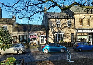
Middleton-in-Teesdale is a market town and civil parish in County Durham, England. It is in Teesdale, on the River Tees's north banks, and surrounded by the North Pennines. The town is between Eggleston and Newbiggin, a few miles to the north-west of Barnard Castle. In 2011 it had a population of 1137.

Harwood is a small valley and village near the head of Teesdale. Harwood Beck is a tributary of the River Tees in County Durham which forms a short valley, and the village is made of the scattered houses and farms which run the length of the valley. The valley forms part of the North Pennines AONB. Lying along the B6277, the village is 9 miles (14 km) north-west of Middleton-in-Teesdale and 21 miles (34 km) south-east of Alston in Cumbria. It is in the civil parish of Forest and Frith, and the Bishop Auckland parliamentary constituency.
Ettersgill is a village in County Durham, England. It is situated at the top of Teesdale, on the north side of the Tees between Newbiggin and Forest-in-Teesdale, and is in the civil parish of Forest and Frith. The village consists of scattered farms and farmhouses, centred on the fertile valley created by Etters Gill Beck, which flows from the mooorland into the Tees south of High Force.
Forest-in-Teesdale is a village in County Durham, England. It is situated in upper Teesdale, on the north side of the Tees between Newbiggin and Langdon Beck, and is in the civil parish of Forest and Frith.

Frosterley is a village in the civil parish of Stanhope, in County Durham, England. It is situated in Weardale, on the River Wear close to its confluence with Bollihope Burn; between Wolsingham and Stanhope; 18 miles (29 km) west of Durham City and 26 miles (42 km) southwest of Newcastle upon Tyne. In the 2001 census Frosterley had a population of 705.

Stanhope is a market town and civil parish in the County Durham district, in the ceremonial county of Durham, England. It lies on the River Wear between Eastgate and Frosterley, in the north-east of Weardale. The main A689 road over the Pennines is crossed by the B6278 between Barnard Castle and Shotley Bridge. In 2001 Stanhope had a population of 1,633, in 2019 an estimate of 1,627, and a figure of 1,602 in the 2011 census for the ONS built-up-area which includes Crawleyside. In 2011 the parish population was 4,581.

Mickle Fell is a mountain in the Pennines, the range of hills and moors running down the middle of Northern England. It has a maximum elevation of 788 m (2,585 ft). It lies slightly off the main watershed of the Pennines, about 10 miles south of Cross Fell. After Cross Fell, Mickle Fell is the highest Marilyn within the North Pennines designated Area of Outstanding Natural Beauty (AONB).
Lunedale is the dale, or valley, of the River Lune, on the east side of the Pennines in England, west of Middleton-in-Teesdale. Its principal settlements are Grassholme, Thringarth and Bowbank.
East Rainton is a village and former civil parish, now in the parish of Hetton, in the Sunderland district, in the county of Tyne and Wear, England. It is situated alongside the A690 road between Sunderland and Durham, near Houghton-le-Spring. In 1931 the parish had a population of 1711. East Rainton was formerly a township and chapelry in the parish of Houghton-le-Spring, from 1866 East Rainton was a civil parish in its own right, on 1 April 1937 the parish was abolished to form Hetton, part also went to Houghton le Spring.

Westgate Methodist Chapel stands on the A689 road in the village of Westgate, some 5 miles (8 km) west of Stanhope, County Durham, England. It is a redundant chapel under the care of the Historic Chapels Trust, and is recorded in the National Heritage List for England as a designated Grade II* listed building.

Harraton is a suburb of Washington, in the Sunderland metropolitan borough, in Tyne and Wear, England. Harraton is near the River Wear and is 3 miles north-east of Chester-le-Street, 2 miles south-west of Washington town centre and 9 miles south-southwest of Sunderland.

Forest and Frith is a civil parish in the County Durham unitary authority, in the ceremonial county of Durham, England. In the 2011 census it had a population of 163.

