Piercebridge

Last updated • 5 min readFrom Wikipedia, The Free Encyclopedia

Piercebridge
Piercebridge St Marys Church 001.jpg
St Mary's Church, Piercebridge
Durham UK location map.svg
Red pog.svg
Piercebridge
Location within County Durham
Population113 (2011)
OS grid reference NZ209157
Unitary authority
Ceremonial county
Region
Country England
Sovereign state United Kingdom
Post town DARLINGTON
Postcode district DL2
Dialling code 01325
Police Durham
Fire County Durham and Darlington
Ambulance North East
UK Parliament
List of places
UK
England
County Durham
54°32′13″N1°40′40″W / 54.53684°N 1.67777°W / 54.53684; -1.67777

Piercebridge is a village and civil parish in the borough of Darlington and the ceremonial county of Durham, England. It is situated a few miles west of the town of Darlington. It is on the site of a Roman fort of AD 260–270, which was built at the point where Dere Street crossed the River Tees. Part of the fort is under the village green. [1] The village is sited where the York-Newstead Roman road known as Dere Street crosses the River Tees. [1]

Contents

The excavated Roman fort is open to the public and the remains of Piercebridge Roman Bridge over the Tees now lie around 90 metres (300 ft) south of the current course of the river, approximately 450 metres (1,480 ft) east of Piercebridge, at the east side of Cliffe, Richmondshire.

Toponym

Piercebridge is named after its Roman bridge or brigg: in 1104 it was Persebrig; in 1577 it was Priestbrigg. It is thought that pierce comes from pershe, meaning osiers, perhaps because the bridge was at least partly made of osier twigs in 1050 when the name is first recorded. Alternative suggested meanings, of "priest" and the name "Piers", would be too modern in origin for such an old place name.

Demographics

The population of the civil parish as of the 2011 census was 113. [2]

History

Roman

The Romans built a fort here to defend the crossing against the Brigantes. [3] The Roman fort known as Morbium is now located under the village green. It was sited adjacent to Dere Street, at the point where the Roman road crossed the River Tees. The fort was occupied continuously from about 70 CE to at least the fifth century. A civilian settlement was to the east of the fort in Tofts Field. [4] A Roman bath house was incorporated into St Mary's chapel (now on private land). [5] [6] The archaeology television programme Time Team was here in 2009, attracted by Piercebridge Roman Fort. [7] Following the departure of the Romans in 410CE, the area in and around the fort remained inhabited for about another century. [4] The plain it sits on in the Tees Valley was the site of Battle of Catraeth. The kingdom of Catraeth was composed of the descendants of the Brigantes. [3]

Medieval

East side of bridge, from Piercebridge,looking south Piercebridge bridge 025.jpg
East side of bridge, from Piercebridge,looking south

There was no permanent inhabitation in the area until the Normans arrived in the mid 11th century.[ citation needed ]

16th century onwards

There was no medieval Piercebridge parish, but there was a chapel recorded in 1546. [8] The name of White Cross Farm and cottage may come from the 17th century apocryphal tale that one of the Dukes of Cleveland demanded the whitewashing of houses on his land so that he could recognise his own property should he require shelter during a storm while hunting. [3] The 18th-century farmhouse, Piercebridge Grange, may be on the site of a monastic grange. It was tenanted by James Rawe, gentleman, in 1847. [9] It is now a Grade II listed building, [10] but was derelict by 2008. [11] The Battle of Piercebridge was partly fought on the bridge, when on 1 December 1642 a small Royalist contingent including William Cavendish defended it against Parliamentarians led by Lord Fairfax. [8] St Mary's church and churchyard were used for 115 extant memorials and burials from 1836 to 1987. [12] In 2001 the Piercebridge area suffered in the foot and mouth epidemic. [13] By 1887, the village had grown to cover 973 acres (3.94 km2) of which 17 were water. It had a population of 206, a railway station and a post office. [14] Since then it has lost the railway station, gained few residents, and retained its post office. [15]

A clock in the George Hotel inspired Henry Clay Work's 1876 song "My Grandfather's Clock". The clock was said to have been owned by two brothers named Jenkins. When one brother died, the clock began losing time, and it stopped forever upon the death of the other. [16]

Preservation

Within the village there are numerous Georgian and Victorian cottages: some painted white or cream; some of one storey only. There are several Grade II listed buildings in the village and its environs, including White Cross Farmhouse, White Cross Cottage, Carlbury Bridge, Piercebridge Grange Farmhouse, the Church of St Mary and its wall and gate, and numbers 2, 28, 29 and 30 on The Green. The Grange farm buildings, however, were developed into residential properties in 2008. [17] Piercebridge Roman Bridge and the medieval chapel ruins on Roman foundations behind Bath House in Tees View are listed Grade II*. [10] The bridge carrying the main B6275 road was originally built in the early 16th century and was widened in 1781; it is Grade II* listed and a Scheduled Ancient Monument. [18] The village green contains some very old trees, and in the river are trout and greyling. [19] At the north end of the village, near the A67 is the Carlbury Arms pub. [20] There is also a Farmway Country Store and Piercebridge Feed Company, retailing rural supplies. [21] The dismantled Tees Valley Railway has become the Tees Valley Railway Path. [22] Church services are held at St Mary's every other week, [23] and there is also a Wesleyan Methodist chapel. [24] [25]

Transport

Originally Dere Street crossed the Tees 260 yards (240 m) further upstream, but in 1771 a flood washed away the remains of the old Roman bridge, and in 1789 a new bridge replaced the ferry. [1] The 1806 map shows Dere Street as the main route via Piercebridge between Richmond and Bishop Auckland, although the Ripon-Durham route went via Darlington. [26] The 1904 map shows the route diverted via Staindrop, and that part of Dere Street between Piercebridge and Bishop Auckland had become a minor road. [27] This was possibly due to the advent of the NER Darlington and Barnard Castle railway (1856) whose Piercebridge station closed to passengers in 1964. According to the land-usage map of 1942, this was an area of arable land and pasture, and the urbanisation around Darlington had not yet begun to encroach. [28]

Related Research Articles

<span class="mw-page-title-main">Darlington</span> Town in County Durham, England

Darlington is a market and industrial town in County Durham, England. It is the main administrative centre of the unitary authority Borough of Darlington. The borough is a constituent member of the devolved Tees Valley area.

<span class="mw-page-title-main">River Tees</span> East coast river of Northern England

The River Tees, in England, rises on the eastern slope of Cross Fell in the North Pennines and flows eastwards for 85 miles (137 km) to reach the North Sea in the North East of England. The modern-day history of the river has been tied with the industries on Teesside in its lower reaches, where it has provided the means of import and export of goods to and from the North East England. The need for water further downstream also meant that reservoirs were built in the extreme upper reaches, such as Cow Green.

<span class="mw-page-title-main">Yarm</span> Town and civil parish in North Yorkshire, England

Yarm, also referred to as Yarm-on-Tees, is a market town and civil parish in the Borough of Stockton-on-Tees, North Yorkshire, England. It is on a small meander of the River Tees. To the south-east, it extends to the River Leven, to the south it extends into the Kirklevington.

<span class="mw-page-title-main">County Durham</span> County of England

County Durham, officially simply Durham (/ˈdʌrəm/), is a ceremonial county in North East England. The county borders Northumberland and Tyne and Wear to the north, the North Sea to the east, North Yorkshire to the south, and Cumbria to the west. The largest settlement is Darlington.

<span class="mw-page-title-main">Borough of Stockton-on-Tees</span> Unitary authority area in County Durham, England

The Borough of Stockton-on-Tees is a unitary authority area in England with borough status. It straddles the ceremonial counties of County Durham and North Yorkshire and had a population of 196,600 in 2021.

<span class="mw-page-title-main">Greta Bridge</span> Human settlement in England

Greta Bridge is a hamlet on the River Greta in the parishes of Rokeby and Brignall in County Durham, England. The bridge is over the River Greta, just south of its confluence with the River Tees. The North Pennines, Teesdale and the Greta Bridge area – including the Meeting of the Waters – became a source of inspiration for romantic artists, poets and writers during the eighteenth century.

<span class="mw-page-title-main">Carlbury</span> Village in County Durham, England

Carlbury is a hamlet in the civil parish of High Coniscliffe in County Durham, in England. It is situated a few miles to the west of Darlington, on the north bank of the River Tees between Piercebridge to the west, and High Coniscliffe to the east. High and Low Carlbury once constituted a slightly larger settlement, but most of the hamlet at Low Carlbury became derelict and was demolished by the late 1940s. A few buildings remain.

<span class="mw-page-title-main">High Coniscliffe</span> Human settlement in England

High Coniscliffe is a parish and village in the borough of Darlington and ceremonial county of County Durham, England. The parish includes Carlbury and Low Coniscliffe. It is part of Heighington and Coniscliffe ward, and is situated approximately 4 miles (6.4 km) west of Darlington. At the 2011 Census the population of this civil parish was 242.

<span class="mw-page-title-main">Merrybent</span> Human settlement in England

Merrybent is a linear village in the civil parish of Low Coniscliffe and Merrybent in County Durham, in England. It is situated on the A67 road to the west of Darlington, a short distance to the north of the River Tees and the Teesdale Way. At the beginning of the 20th century there were hardly any buildings here, and its main feature at that time was Merrybent Nurseries with its many glasshouses. The nursery was cut through by the A1 road in the 1960s; at this point it runs on the trackbed of the old Merrybent railway. The village is now a settlement of modern housing.

<span class="mw-page-title-main">Dere Street</span> Roman road that ran from York in England to the Antonine Wall in Scotland

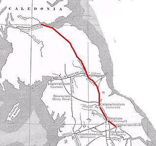
Dere Street or Deere Street is a modern designation of a Roman road which ran north from Eboracum (York), crossing the Stanegate at Corbridge and continuing beyond into what is now Scotland, later at least as far as the Antonine Wall. It was the Romans' major route for communications and supplies to the north and to Scotland. Portions of its route are still followed by modern roads, including the A1(M), the B6275 road through Piercebridge, where Dere Street crosses the River Tees, and the A68 north of Corbridge in Northumberland.

Faverdale is a suburb of Darlington in County Durham, England. It is situated in the north west of Darlington, north of Cockerton. The area was rural until the 20th century, a large wagon works was established in the 1920s, with housing development starting at the same time. The wagon works closed in the 1960s and further industrial and commercial development took place expanding from the brownfield site. As of 2012 the area has a mixture of industrial, residential and rural land use.

<span class="mw-page-title-main">Hurworth-on-Tees</span> Human settlement in England

Hurworth-on-Tees is a village in the borough of Darlington, within the ceremonial county of County Durham, England. It is situated in the civil parish of Hurworth. The village lies to the south of Darlington on the River Tees, close to its meeting point with the River Skerne, and immediately adjoins the village of Hurworth Place, which forms part of the same civil parish.

<span class="mw-page-title-main">Borough of Darlington</span> Unitary authority area in County Durham, England

The Borough of Darlington is a unitary authority area with borough status in County Durham, England. Since 1997 Darlington Borough Council has been a unitary authority; it is independent from Durham County Council. It is named after its largest settlement, the town of Darlington, where the council is based. The borough also includes a rural area surrounding the town which contains several villages. The population of the borough at the 2021 census was 107,800, of which over 86% (93,015) lived in the built-up area of Darlington itself.

<span class="mw-page-title-main">Dalton-on-Tees</span> Village and civil parish in North Yorkshire, England

Dalton-on-Tees is a village and civil parish in North Yorkshire, England, near the boundary with County Durham. According to the 2001 Census there were 318 people living in the parish in 120 houses. The population had decreased to 303 by the time of the 2011 Census.

<span class="mw-page-title-main">Cliffe, Richmondshire</span> Village and civil parish in North Yorkshire, England

Cliffe is a small village and civil parish in Richmondshire district of North Yorkshire, England. A stream called the Glen runs through the village to the Tees. It is in the Teesdale and Yorkshire Dales national park. It is about 6 miles (10 km) west of Darlington, 10 miles (16 km) north of Richmond and near Piercebridge.

<span class="mw-page-title-main">River Skerne</span> River in County Durham, England

The River Skerne is a tributary of the River Tees. It flows through County Durham in England.

<span class="mw-page-title-main">Piercebridge Roman Fort</span> Roman fort in Durham, England

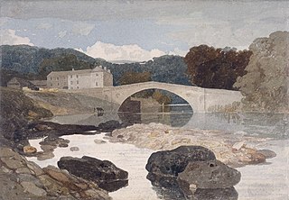
Piercebridge Roman Fort is a scheduled ancient monument situated in the village of Piercebridge on the banks of the River Tees in modern-day County Durham, England. There were Romans here from about AD 70 until at least the early 5th century. There was an associated vicus and bath house at Piercebridge, and another vicus and a villa south of the river at Cliffe. The Victorians used carved stones from this site when they built St Mary's church at Gainford. Part of the site is under Piercebridge village green.

<span class="mw-page-title-main">Piercebridge Roman Bridge</span> Former bridge over the River Tees in Northern England

Piercebridge Roman Bridge is the ruin of a Roman bridge over the River Tees, northern England. It is near the villages of Cliffe and Piercebridge, County Durham.

References

  1. 1 2 3 Simpson, David (1991–2009). "Roots of the Region". Piercebridge (County Durham). Retrieved 14 January 2010.
  2. "Civil parish population 2011" . Retrieved 3 February 2016.
  3. 1 2 3 Simpson, David (1991–2009). "County Durham". Teesdale and Barnard Castle. Retrieved 12 March 2010.
  4. 1 2 Evans, Tim (1996–2010). "ADS Archsearch". Roman Piercebridge ALSF Project Number 4698. Retrieved 9 March 2010.
  5. "Keys to the Past". Piercebridge, St. Mary's; site of Medieval chapel. (Piercebridge). County Durham. 2010. Archived from the original on 16 May 2007. Retrieved 9 March 2010.
  6. "Darlington.gov.uk" (PDF). Piercebridge conservation area character appraisal, consultation draft. Darlington. 2005. Retrieved 9 March 2010.
  7. Lloyd, Chris (2 July 2009). "The Northern Echo". Piercebridge: Time Team investigates. Archived from the original on 27 September 2012. Retrieved 9 March 2010.
  8. 1 2 "Keys to the Past". Local History Piercebridge (County Durham). Northumberland County Council. 2010. Archived from the original on 16 May 2007. Retrieved 14 January 2010.
  9. "Last will and testament of John Chapman, 1847". Citation. 1847. Retrieved 12 March 2010.
  10. 1 2 "Darlington Borough Council: Index of buildings in Darlington borough" (PDF). Parish Piercebridge. Regeneration Division, chief executive's Department, Darlington Borough Council. 19 August 2008. p. 42. Retrieved 12 March 2010.
  11. "Buildings at risk register" (PDF). Piercebridge Grange Farm. Darliington Borough Council. 2008. p. 31. Retrieved 12 March 2010.
  12. "Federation of Family History Societies". Cleveland, North Yorkshire and County Durham Memorial Inscription index. 2002–2009. Archived from the original on 19 February 2010. Retrieved 12 March 2010.
  13. "Timeline: Foot-and-mouth cases". BBC News. 19 October 2001. Retrieved 12 March 2010.
  14. Bartholomew, John (1887). "A vision of Britain through time: Piercebridge County Durham". 1887, John Bartholomew's Gazetteer of the British Isles. Retrieved 12 March 2010.
  15. "Thomson local.com". Piercebridge Post Office. 2010. Retrieved 12 March 2010.
  16. "History of the Grandfather Clock at the George Hotel in Piercebridge, Darlington, County Durham - The George Hotel". The George Hotel. Archived from the original on 3 September 2014. Retrieved 27 August 2014.
  17. "Charltons". Details for Piercebridge Grange – For Sale. 2008. Archived from the original on 8 July 2011. Retrieved 12 March 2010.
  18. Historic England (3 November 2000). "PIERCEBRIDGE BRIDGE (1145843)". National Heritage List for England . Retrieved 22 April 2020.
  19. "Information Britain". A guide to Piercebridge on Tees. 2009. Retrieved 9 March 2010.
  20. "Living: restaurant guide". Carlbury Arms, Piercebridge. 23 March 2009. Archived from the original on 19 June 2009. Retrieved 12 March 2010.
  21. "Farmway". Suppliers to the rural community. 2009. Archived from the original on 18 June 2010. Retrieved 12 March 2010.
  22. "The long distance walkers association". Tees Valley Railway Path. Retrieved 12 March 2010.
  23. "Churchindarlington.org.uk". St Mary's Church, Piercebridge. Retrieved 12 March 2010.
  24. "durham-pa.gov.uk". Piercebridge, Wesleyan chapel. Durham County Council. 1981. Retrieved 12 March 2010.[ dead link ]
  25. "The National Archives". Piercebridge Methodist Church, 1864–1961 minutes and accounts. 2009. Retrieved 12 March 2010.
  26. Smith, C. (1806). "A vision of Britain through time: historical maps". C.Smith: New Map of Great Britain and Ireland, central England, 1806, 1:633600. Retrieved 12 March 2010.
  27. Ordnance Survey (1904). "A vision of Britain through time: historical maps". Ordnance Survey sheets 7 and 8, 1904, 1:633600. OS. Retrieved 12 March 2010.
  28. "A vision of Britain through time: his torical maps". Geographical Publications Limited Land Utilisation Survey of Britain, Sheet 2. Ordnance Survey. 1942. Retrieved 12 March 2010.