
Askham Richard is a village and civil parish in the unitary authority of City of York in the north of England, 6.5 miles (10.5 km) south-west of York, close to Copmanthorpe, Bilbrough and Askham Bryan. The population of the civil parish at the 2011 census was 351. The village became a Conservation Area in 1975. Nearby is Askham Bryan College of Agriculture.

Brierley is a village in the Metropolitan Borough of Barnsley in South Yorkshire, England. The settlement is tightly clustered and green buffered on a modest escarpment close to the border with West Yorkshire, it is almost wholly in population south of the A628 road, and is less than 2 miles (3 km) to the south west of Hemsworth.

Ingleton is a village and civil parish in County Durham, England. The population of the parish as taken at the 2011 census was 420. It is situated about eight miles to the west of Darlington, and a short distance from the villages of Langton, Hilton and Killerby. The Church of St John the Evangelist in Ingleton was built in 1843 by Ignatius Bonomi and J.A. Cory., and is a Grade II listed building.

Shilton is a village and civil parish about 1+1⁄2 miles (2.4 km) northwest of Carterton, Oxfordshire. The 2011 Census recorded the parish's population as 626.

Conistone is a small village in the Craven district of North Yorkshire, England. It lies 3 miles (5 km) north of Grassington, 3 miles (5 km) south of Kettlewell and 12 miles (19 km) north of Skipton beside the River Wharfe, in Upper Wharfedale.

Sheriff Hutton is a village and civil parish in North Yorkshire, England. It lies about 10 miles (16 km) north by north-east of York.

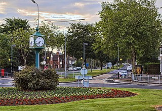
Topcliffe is a village and civil parish in North Yorkshire, England. The village is situated on the River Swale, on the A167 road and close to the A168. It is about 5 miles (8 km) south-west of Thirsk and 11 miles (18 km) south of the county town of Northallerton. It has a population of 1,489. An army barracks, with a Royal Air Force airfield enclosed within, is located to the north of the village.
Willerby is a village and civil parish located on the western outskirts of the city of Kingston upon Hull in the East Riding of Yorkshire, England.
Maltby is a village and civil parish in the borough of Stockton-on-Tees and ceremonial county of North Yorkshire, England. It is located to the east of the A19. The population of the civil parish taken at the 2011 census was 293.

Stainton is a village in the south-west outskirts of Middlesbrough, in the Middlesbrough district, in the ceremonial county of North Yorkshire, England.

Croft-on-Tees is a village and civil parish in North Yorkshire, England. It has also been known as Croft Spa, and from which the former Croft Spa railway station took its name. It lies 11 miles (18 km) north-north west of the county town of Northallerton.

Downholme is a village and civil parish in North Yorkshire, England. It is situated approximately 4 miles (6 km) west from the market town of Richmond and 16 miles (26 km) west from the county town of Northallerton. The village lies close to the edge of the Yorkshire Dales. The population as taken in the ONS Census of 2011 was less than 100, so details are included in the parish of Hudswell. In 2015, North Yorkshire County Council estimated the population of the village to be 50.

Heanton Punchardon ( ) is a village, civil parish and former manor, anciently part of Braunton Hundred. It is situated directly east-southeast of the village of Braunton, in North Devon. The parish lies on the north bank of the estuary of the River Taw and it is surrounded, clockwise from the north, by the parishes of Braunton, Marwood, Ashford and across the estuary, Fremington. The population was 418 in 1801 and 404 in 1901. Its largest localities are Wrafton and Chivenor. The surrounding area is also an electoral ward with a total population at the 2011 census of 2,673.

Kirby Sigston is a denucleated village and civil parish in North Yorkshire, England, approximately 4 miles (6.4 km) east of Northallerton. The parish is situated on the Cod Beck river, and also includes the hamlet of Jeater Houses, east of the village on the A19 road, on the boundary with Thimbleby.
Crathorne is a village and civil parish in North Yorkshire, England. The parish population was 172 at the 2011 census. The River Leven flows through the parish. The A19 used to run through the village before a dual carriageway was built in 1975. Now the A67 follows the route of the old A19 north towards Yarm.
St John the Evangelist's Church is an Anglican church in the Preston Village area of Brighton, in the English city of Brighton and Hove. The Grade II listed building, designed by Sir Arthur Blomfield, was started in 1901 but did not take its present form for another quarter of a century. In the meantime, the nearby parish church of Preston was severely damaged by fire, and the new church was granted the parish church status which it still retains.
Thirkleby High and Low with Osgodby is a civil parish in North Yorkshire, England. The parish includes the villages of Great Thirkleby and Little Thirkleby and the scattered hamlet of Osgodby. The similarly named medieval settlement of Thirkleby Manor is around 30 miles north, in the parish of Kirby Grindalythe, Ryedale District. The population of the civil parish taken at the 2011 Census was 266.
Hartwith cum Winsley is a civil parish in former Harrogate district, North Yorkshire, England. Historically it was a township in the ancient parish of Kirkby Malzeard in the West Riding of Yorkshire, a detached part of that parish. It became a separate civil parish in 1866, and was transferred to North Yorkshire in 1974.

Tubney is a small village and former civil parish, now in the parish of Fyfield and Tubney, in the Vale of White Horse district, in Oxfordshire, England. It lies about 3 miles west of Abingdon-on-Thames, just south of the A420 road from Oxford to Faringdon, 9 miles (14 km) southwest of Oxford. In 1951 the parish had a population of 215.
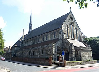
The Church of St Peter is a Church of England parish church in Hilton in the borough of Stockton-on-Tees and in the county of North Yorkshire. The church dates from the 12th century and is a Grade I listed building.


