
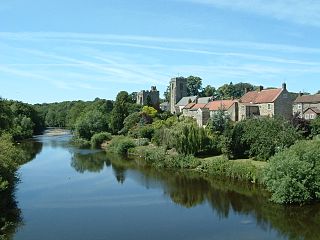
Yarm, also referred to as Yarm-on-Tees, is a market town and civil parish in the Borough of Stockton-on-Tees, North Yorkshire, England. It is in Teesdale with a town centre on a small meander of the River Tees. To the south-east, it extends to the River Leven, to the south it extends into the Kirklevington.

Thirsk is a market town and civil parish in North Yorkshire, England; it is known for its racecourse, quirky yarn bombing displays and depiction as local author James Herriot's fictional Darrowby.

The Borough of Stockton-on-Tees is a unitary authority area in England with borough status. It straddles the ceremonial counties of County Durham and North Yorkshire and had a population of 196,600 in 2021.

Ingleby Barwick is a town and civil parish in the Borough of Stockton-on-Tees, North Yorkshire, England. It is south of the River Tees and north-east of the River Leven.
Aislaby is a small village and civil parish on the north bank of the River Tees within the borough of Stockton-on-Tees and the ceremonial county of County Durham, England. It is located to the west of Eaglescliffe and Yarm. The name, first attested as Asulue(s)bi in 1086, is of Viking origin and means "Aslak's farm." Aislaby was listed in the Domesday Book of 1086.

Barwick-in-Elmet is a village in West Yorkshire, 7 miles (11 km) east of Leeds city centre. It is one of only three places in the area to be explicitly associated with the ancient Romano-British kingdom of Elmet, the others being Scholes-in-Elmet and Sherburn-in-Elmet.

Stockton South was a constituency represented in the House of Commons of the UK Parliament from 2019 until its abolition for the 2024 general election by Matt Vickers of the Conservative Party.

Acklam is an area in the Borough of Middlesbrough, North Yorkshire, England. It is believed that the settlement is Anglo-Saxon in origin, the name is Old English for "place at the oak clearings" or "place of oaks". Acklam was an ancient parish, being known as West Acklam to distinguish it from Acklam in Ryedale.

Barton is a village and civil parish in North Yorkshire, England. According to the 2011 census it had a population of 837. It is situated near the border with the ceremonial county of County Durham, and is 6 miles south-west of Darlington.
Stokesley was a rural district in the North Riding of Yorkshire from 1894 to 1974. It was named after the town of Stokesley, which it contained.
High Leven is a village of Ingleby Barwick in North Yorkshire, England. It is in the borough of Stockton-on-Tees, on top of the River Leven's dell. It has a public house called The Fox Covert and a co-operative food store, open every day 05:00 to 24:00, with an ATM and petrol station.
West Tanfield is a village and civil parish in the Hambleton district of North Yorkshire, England. The village is situated approximately six miles north of Ripon on the A6108, which goes from Ripon to Masham and Wensleydale. The parish includes the hamlets of Nosterfield, Thornborough and Binsoe.
Langbaurgh West was a division of the wapentake of Langbaurgh in the North Riding of the ancient county of Yorkshire. The area along with Langbaurgh East forms the Anglo-Saxon baronial Liberty of Cleveland and roughly covers the modern districts of Middlesbrough, the western, urbanised portion of Redcar & Cleveland, the southern portion of Stockton-on-Tees, the northern parts of Hambleton and the northern parts of the Borough of Scarborough.

Stainton and Thornton is a civil parish in Middlesbrough, North Yorkshire, England. It consists of the two villages Stainton and Thornton. The population of the civil parish at the 2011 census was 1,243.
All Saints Academy is a mixed Church of England secondary school located in Ingleby Barwick in the Borough of Stockton-on-Tees, North Yorkshire, England.
Ingleby Manor Free School is a mixed secondary school and sixth form with free school status. It is located in Maltby, North Yorkshire, England. It had an enrolment of over 450 pupils, ages 11–16, as of 2024.

Stockton West is a constituency of the House of Commons in the UK Parliament. Further to the completion of the 2023 Periodic Review of Westminster constituencies, it was first contested at the 2024 general election, when it was won by Matt Vickers of the Conservative Party. It is now the only seat held by the Conservatives in the North East of England.

The 2023 Stockton-on-Tees Borough Council election took place on 4 May 2023 to elect all 56 members of Stockton-on-Tees Borough Council, a unitary authority which straddles the ceremonial counties of County Durham and North Yorkshire in England. This was on the same day as other local elections across England.
