PA postcode area

Last updated

Template:Attached KML/PA postcode area
KML is from Wikidata
Paisley
United Kingdom adm location map.svg
Red pog.svg
PA
Coordinates: 55°55′16″N4°47′24″W / 55.921°N 4.790°W / 55.921; -4.790
CountryUnited Kingdom
Postcode area
PA
Postcode area name
Paisley
Post towns 35
Postcode districts 77
Postcode sectors114
Postcodes (live)9,357
Postcodes (total)12,921
Statistics as at May 2020 [1]

The PA postcode area, also known as the Paisley postcode area, [2] is a group of 67 postcode districts in western Scotland, within 35 post towns. These cover Renfrewshire (including Paisley, Renfrew, Johnstone, Bishopton, Erskine, Bridge of Weir and Lochwinnoch), Inverclyde (including Greenock, Port Glasgow, Gourock, Kilmacolm and Wemyss Bay) and most of Argyll and Bute (including Oban, Lochgilphead, Tarbert, Campbeltown, Appin, Taynuilt, Bridge of Orchy, Dalmally, Inveraray, Cairndow, Colintraive, Dunoon, Tighnabruaich, and the Isles of Mull, Iona, Coll, Tiree, Jura, Colonsay, Islay, Gigha and Bute), plus small parts of North Ayrshire (including Skelmorlie) and Highland.

Contents

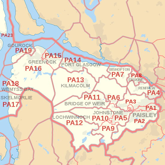
Coverage

The approximate coverage of the postcode districts:

Postcode district Post town CoverageLocal authority area(s)
PA1PAISLEY Paisley (central, east and north east), Ralston Renfrewshire
PA2PAISLEYPaisley (south), Castlehead Renfrewshire, and a small rural area in East Renfrewshire
PA3PAISLEYPaisley (north west), Linwood Renfrewshire
PA4RENFREW Renfrew, Inchinnan Renfrewshire
PA5JOHNSTONE Johnstone, Brookfield, Elderslie Renfrewshire
PA6JOHNSTONEJohnstone, Houston Renfrewshire
PA7BISHOPTON Bishopton Renfrewshire
PA8ERSKINE Erskine Renfrewshire
PA9JOHNSTONEJohnstone, Howwood Renfrewshire
PA10JOHNSTONEJohnstone, Kilbarchan Renfrewshire
PA11BRIDGE OF WEIR Bridge of Weir, Quarrier's Village Renfrewshire
PA12LOCHWINNOCH Lochwinnoch, Newton of Belltrees Renfrewshire
PA13KILMACOLM Kilmacolm Inverclyde
PA14PORT GLASGOW Port Glasgow, Langbank Inverclyde
PA15GREENOCK Greenock Inverclyde
PA16GREENOCKGreenock, Inverkip Inverclyde
PA17SKELMORLIE Skelmorlie North Ayrshire
PA18WEMYSS BAY Wemyss Bay Inverclyde
PA19GOUROCK Gourock Inverclyde
PA20ISLE OF BUTE Isle of Bute Argyll and Bute
PA21TIGHNABRUAICH Tighnabruaich Argyll and Bute
PA22COLINTRAIVE Colintraive, Glendaruel Argyll and Bute
PA23DUNOON Dunoon Argyll and Bute
PA24CAIRNDOW Lochgoilhead Argyll and Bute
PA25CAIRNDOW St. Catherines Argyll and Bute
PA26CAIRNDOW Cairndow Argyll and Bute
PA27CAIRNDOW Strachur Argyll and Bute
PA28CAMPBELTOWN Campbeltown Argyll and Bute
PA29TARBERT Tarbert Argyll and Bute
PA30LOCHGILPHEAD Ardrishaig Argyll and Bute
PA31LOCHGILPHEAD Lochgilphead, Cairnbaan, Crinan, Kilmartin Argyll and Bute
PA32INVERARAY Inveraray Argyll and Bute
PA33DALMALLY Dalmally Argyll and Bute
PA34OBAN Oban Argyll and Bute
PA35TAYNUILT Taynuilt Argyll and Bute
PA36BRIDGE OF ORCHY Bridge of Orchy Argyll and Bute
PA37OBAN Connel, Benderloch Argyll and Bute
PA38APPIN Appin Argyll and Bute, Highland
PA41ISLE OF GIGHA Gigha Argyll and Bute
PA42ISLE OF ISLAY Port Ellen Argyll and Bute
PA43ISLE OF ISLAY Bowmore Argyll and Bute
PA44ISLE OF ISLAY Bridgend Argyll and Bute
PA45ISLE OF ISLAY Ballygrant Argyll and Bute
PA46ISLE OF ISLAY Port Askaig Argyll and Bute
PA47ISLE OF ISLAY Portnahaven Argyll and Bute
PA48ISLE OF ISLAY Port Charlotte Argyll and Bute
PA49ISLE OF ISLAY Bruichladdich Argyll and Bute
PA60ISLE OF JURA Jura Argyll and Bute
PA61ISLE OF COLONSAY Colonsay Argyll and Bute
PA62ISLE OF MULL Lochbuie Argyll and Bute
PA63ISLE OF MULL Croggan Argyll and Bute
PA64ISLE OF MULL Lochdon Argyll and Bute
PA65ISLE OF MULL Craignure Argyll and Bute
PA66ISLE OF MULL Fionnphort Argyll and Bute
PA67ISLE OF MULL Bunessan Argyll and Bute
PA68ISLE OF MULL Gribun Argyll and Bute
PA69ISLE OF MULL Tiroran Argyll and Bute
PA70ISLE OF MULL Pennyghael Argyll and Bute
PA71ISLE OF MULL Gruline Argyll and Bute
PA72ISLE OF MULL Aros, Salen Argyll and Bute
PA73ISLE OF MULL Ulva Ferry Argyll and Bute
PA74ISLE OF MULL Torloisk Argyll and Bute
PA75ISLE OF MULL Tobermory, Calgary Argyll and Bute
PA76ISLE OF IONA Iona Argyll and Bute
PA77ISLE OF TIREE Tiree Argyll and Bute
PA78ISLE OF COLL Coll Argyll and Bute
PA80OBAN Morvern Highland

Ballachulish and Kinlochleven were originally coded PA39 and PA40 respectively, before being transferred to the PH area in 1999 as PH49 and PH50. [3] The PA80 district was formed out of the PA34 district in 2011 following a campaign by residents of Morvern. [4] [5]

Until January 1995, PA80 to PA87 were allocated to the islands of the Outer Hebrides, after which these formed the HS postcode area.

Map

Template:Attached KML/PA postcode area
KML is from Wikidata
PA postcode area map, showing postcode districts in red and post towns in grey text, with links to nearby BT, FK, G, KA and PH postcode areas. PA postcode area map.svg
PA postcode area map, showing postcode districts in red and post towns in grey text, with links to nearby BT, FK, G, KA and PH postcode areas.
Detailed map of postcode districts and post towns in and around Paisley PA postcode area inset map.svg
Detailed map of postcode districts and post towns in and around Paisley

See also

Related Research Articles

The CM postcode area, also known as the Chelmsford postcode area, is a group of 25 postcode districts in England, within 16 post towns. These cover central Essex, plus a small part of east Hertfordshire and a very small part of the London Borough of Havering.

The CV postcode area, also known as the Coventry postcode area, is a group of 24 postcode districts in central England, within eleven post towns. These cover the eastern part of the West Midlands county, most of Warwickshire, a part of west Leicestershire and a very small part of Northamptonshire.

The GU postcode area, also known as the Guildford postcode area, is a group of 38 postcode districts in South East England, within 24 post towns. These cover west Surrey, north-east Hampshire, northwestern West Sussex and a small part of south-east Berkshire.

The M postcode area, also known as the Manchester postcode area, is a group of postcode districts in the North West of England.

The WD postcode area, also known as the Watford postcode area, is a group of eleven postcode districts in Greater London and Hertfordshire, within seven post towns. These cover south-west Hertfordshire, plus very small parts of Buckinghamshire and the London Borough of Hillingdon.

The RG postcode area, also known as the Reading postcode area, is a group of thirty postcode districts in England, within twelve post towns. These cover west and central Berkshire and north Hampshire, plus a small part of south-east Oxfordshire and very small parts of Buckinghamshire and Wiltshire.

The LE postcode area, also known as the Leicester postcode area, is a group of 21 postcode districts in central England, within 12 post towns. These cover most of Leicestershire and Rutland, plus small parts of south Nottinghamshire and north Northamptonshire, and very small parts of Derbyshire and Warwickshire.

The LS postcode area, also known as the Leeds postcode area, is a group of 29 postcode districts in England, within six post towns. These cover northern West Yorkshire and some parts of North Yorkshire.

The OX postcode area, also known as the Oxford postcode area, is a group of 26 postcode districts in south-central England, within 17 post towns. These cover most of Oxfordshire, plus very small parts of Northamptonshire, Buckinghamshire, Berkshire, Gloucestershire and Warwickshire.

The CA postcode area, also known as the Carlisle postcode area, is a group of 28 postcode districts in north-west England, within 22 post towns. These cover northern Cumbria, including Carlisle, Penrith, Workington, Whitehaven, Maryport, Cockermouth, Egremont, Alston, Appleby-in-Westmorland, Beckermet, Brampton, Cleator, Cleator Moor, Frizington, Holmrook, Keswick, Kirkby Stephen, Moor Row, Ravenglass, Seascale, St Bees and Wigton, plus a very small part of Northumberland.

The BD postcode area, also known as the Bradford postcode area, is a group of 24 postcode districts in England, within seven post towns. These cover northwestern West Yorkshire and southwestern North Yorkshire, plus very small parts of Lancashire.

The PL postcode area, also known as the Plymouth postcode area, is a group of 35 postcode districts in South West England, within 25 post towns. These cover west Devon and east Cornwall.

The SN postcode area, also known as the Swindon postcode area, is a group of eighteen postcode districts in England, within ten post towns. These cover north Wiltshire, plus a small part of south-west Oxfordshire and a very small part of Gloucestershire.

The PH postcode area, also known as the Perth postcode area, is a group of 43 postcode districts for post towns: Aberfeldy, Acharacle, Arisaig, Auchterarder, Aviemore, Ballachulish, Blairgowrie, Boat of Garten, Carrbridge, Corrour, Crieff, Dalwhinnie, Dunkeld, Fort Augustus, Fort William, Glenfinnan, Grantown-on-Spey, Invergarry, Isle of Canna, Isle of Eigg, Isle of Rum, Kingussie, Kinlochleven, Lochailort, Mallaig, Nethy Bridge, Newtonmore, Perth, Pitlochry, Roy Bridge and Spean Bridge in Scotland.

The FK postcode area, also known as the Falkirk postcode area, is a group of 21 postcode districts in central Scotland, within 18 post towns. These cover most of the Falkirk council area, most of the Stirling council area and Clackmannanshire, plus small parts of Fife, Perth and Kinross, and Argyll and Bute.

The BB postcode area, also known as the Blackburn postcode area, is a group of thirteen postcode districts in north-west England, within nine post towns. These cover east Lancashire, including Blackburn, Burnley, Accrington, Barnoldswick, Clitheroe, Colne, Darwen, Nelson and Rossendale.

The L postcode area, also known as the Liverpool postcode area, is a group of postcode districts in North West England. Together they cover central and southern Merseyside, southern West Lancashire, and a small part of north-west Cheshire. Its four post towns are Bootle, Liverpool, Ormskirk, and Prescot.

The G postcode area, also known as the Glasgow postcode area, is a group of postcode districts in central Scotland, within five post towns. These districts are primarily centered on Glasgow itself, and West Dunbartonshire, plus parts of the council areas of Argyll and Bute, East Dunbartonshire, North Lanarkshire, South Lanarkshire, East Renfrewshire and Stirling.

The HX postcode area, also known as the Halifax postcode area, is a group of seven postcode districts in England, within four post towns. These cover most of the Metropolitan Borough of Calderdale in western West Yorkshire, including Halifax, Elland, Sowerby Bridge and Hebden Bridge.

The HS postcode area, also known as the Outer Hebrides postcode area, is a group of nine postcode districts, within eight post towns, covering the Outer Hebrides in Scotland.

References

  1. "ONS Postcode Directory Version Notes" (ZIP). National Statistics Postcode Products. Office for National Statistics. May 2020. Table 2. Retrieved 19 June 2020. Coordinates from mean of unit postcode points, "Code-Point Open". OS OpenData. Ordnance Survey. February 2012. Retrieved 21 April 2012.
  2. Royal Mail, Address Management Guide, (2004)
  3. "Royal Mail Postcode Update 30". Beacon Dodsworth. Archived from the original on 22 April 2017. Retrieved 22 April 2017.
  4. "Morvern secures its own postcode from Royal Mail". BBC News. 22 December 2009. Retrieved 22 December 2009.
  5. "Royal Mail Postcode Update 52". Beacon Dodsworth. Archived from the original on 23 April 2017. Retrieved 22 April 2017.