| Postcode district | Post town | Coverage | Local authority area(s) |
|---|
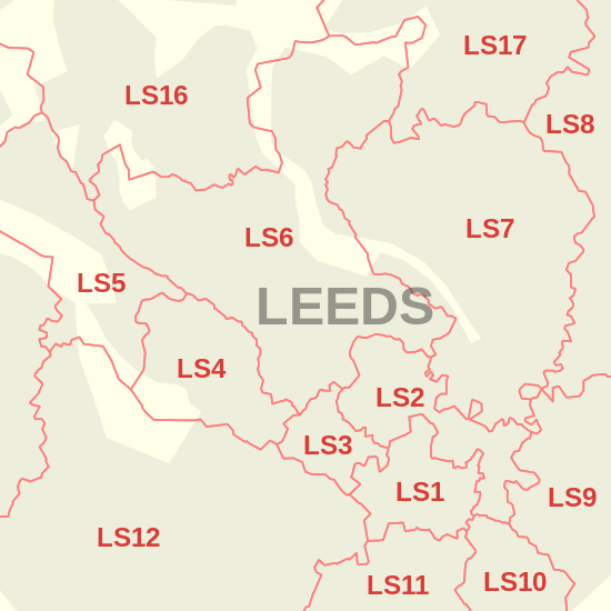
| LS1 | LEEDS | Leeds city centre | Leeds |
|---|
| LS2 | LEEDS | Leeds city centre, Woodhouse | Leeds |
|---|
| LS3 | LEEDS | Burley, Woodhouse | Leeds |
|---|
| LS4 | LEEDS | Burley, Kirkstall | Leeds |
|---|
| LS5 | LEEDS | Hawksworth, Kirkstall | Leeds |
|---|
| LS6 | LEEDS | Beckett Park, Burley, Headingley, Hyde Park, Meanwood, Woodhouse | Leeds |
|---|
| LS7 | LEEDS | Beck Hill, Buslingthorpe, Chapel Allerton, Chapeltown, Little London, Lovell Park, Meanwood, Miles Hill, Potternewton, Scott Hall, Sheepscar | Leeds |
|---|
| LS8 | LEEDS | Fearnville, Gipton, Gledhow, Harehills, Moortown, Oakwood, Roundhay | Leeds |
|---|
| LS9 | LEEDS | Burmantofts, Cross Green, East End Park, Gipton, Harehills, Mabgate, Osmondthorpe, Richmond Hill, Halton Moor | Leeds |
|---|
| LS10 | LEEDS | Belle Isle, Hunslet, Leeds city centre, Middleton, Stourton | Leeds |
|---|
| LS11 | LEEDS | Leeds city centre, Beeston, Beeston Hill, Cottingley, Holbeck | Leeds |
|---|
| LS12 | LEEDS | Armley, Farnley, New Farnley, Wortley | Leeds |
|---|
| LS13 | LEEDS | Bramley, Gamble Hill, Moorside, Rodley, Swinnow | Leeds |
|---|
| LS14 | LEEDS | Fearnville, Killingbeck, Seacroft, Scarcroft, Swarcliffe, Thorner, Whinmoor | Leeds |
|---|
| LS15 | LEEDS | Austhorpe, Barwick-in-Elmet, Colton, Cross Gates, Halton, Halton Moor, Manston, Pendas Fields, Scholes, Temple Newsam, Whitkirk, Killingbeck, Swarcliffe | Leeds |
|---|
| LS16 | LEEDS | Adel, Bramhope, Cookridge, Eccup, Far Headingley, Holt Park, Ireland Wood, Lawnswood, Moor Grange, Tinshill, Weetwood, West Park | Leeds |
|---|
| LS17 | LEEDS | Alwoodley, Bardsey, East Keswick, Eccup, Harewood, Moortown, Shadwell, Slaid Hill, Weardley, Wike | Leeds, North Yorkshire |
|---|
| LS18 | LEEDS | Horsforth | Leeds |
|---|
| LS19 | LEEDS | Carlton, Rawdon, Yeadon | Leeds |
|---|
| LS20 | LEEDS | Guiseley, Hawksworth | Leeds |
|---|
| LS21 | OTLEY | Arthington, Otley, Pool, Blubberhouses | Leeds, North Yorkshire |
|---|
| LS22 | WETHERBY | Collingham, Linton, Wetherby | Leeds |
|---|
| LS23 | WETHERBY | Boston Spa, Bramham, Clifford, Thorp Arch, Walton | Leeds |
|---|
| LS24 | TADCASTER | Saxton, Stutton, Ulleskelf, Church Fenton, Oxton, Tadcaster, Toulston, Wighill, Ryther cum Ossendyke | North Yorkshire |
|---|
| LS25 | LEEDS | Aberford, Garforth, Hillam, Kippax, Ledsham, Micklefield, Monk Fryston, Sherburn-in-Elmet, South Milford | Leeds, North Yorkshire |
|---|
| LS26 | LEEDS | Great Preston, Methley, Mickletown, Oulton, Rothwell, Swillington, Woodlesford | Leeds |
|---|
| LS27 | LEEDS | Churwell, Gildersome, Morley | Leeds |
|---|
| LS28 | PUDSEY | Bagley, Calverley, Farsley, Fulneck, Pudsey, Stanningley | Leeds |
|---|
| LS29 | ILKLEY | Addingham, Ben Rhydding, Burley in Wharfedale, Burley Woodhead, Denton, Ilkley, Menston, Middleton | Bradford, Leeds, North Yorkshire |
|---|
| LS88 | LEEDS | Jobcentre Plus | Non-geographic |
|---|
| LS98 | LEEDS | First Direct | Non-geographic |
|---|
| LS99 | LEEDS | PO Boxes | Non-geographic |
|---|