| Postcode district | Post town | Coverage | Local authority area(s) |
|---|
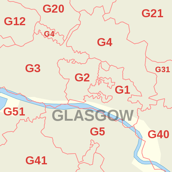
| G1 | GLASGOW | Former C1 district: Merchant City | Glasgow City |
|---|
| G2 | GLASGOW | Former C2 district: Blythswood Hill, Anderston (part) | Glasgow City |
|---|
| G3 | GLASGOW | Former C3 district: Anderston, Finnieston, Garnethill, Kelvingrove, Park, Woodlands (part), Yorkhill | Glasgow City |
|---|
| G4 | GLASGOW | Former C4 district: Calton (part), Cowcaddens (part), Drygate, Kelvinbridge, Townhead, Woodlands (part), Woodside (part) | Glasgow City |
|---|
| G5 | GLASGOW | Former C5 district: Gorbals | Glasgow City |
|---|
| G9 | GLASGOW | Newspaper Competitions | non-geographic |
|---|
| G11 | GLASGOW | Former W1 district: Broomhill, Partick, Partickhill | Glasgow City |
|---|
| G12 | GLASGOW | Former W2 district: West End (part), Cleveden, Dowanhill, Hillhead, Hyndland, Kelvindale, Kelvinside, Botanic Gardens, University of Glasgow | Glasgow City |
|---|
| G13 | GLASGOW | Former W3 district: Anniesland, Knightswood, Yoker (part) | Glasgow City |
|---|
| G14 | GLASGOW | Former W4 district: Whiteinch, Scotstoun, Yoker (part) | Glasgow City |
|---|
| G15 | GLASGOW | Former W5 district: Drumchapel | Glasgow City |
|---|
| G20 | GLASGOW | Former NW district: Maryhill, North Kelvinside, Ruchill | Glasgow City |
|---|
| G21 | GLASGOW | Former N1 district: Balornock, Barmulloch, Cowlairs, Royston, Springburn, Sighthill | Glasgow City |
|---|
| G22 | GLASGOW | Former N2 district: Milton, Parkhouse, Possilpark | Glasgow City |
|---|
| G23 | GLASGOW | Former N3 district: Lambhill, Summerston | Glasgow City |
|---|
| G31 | GLASGOW | Former E1 district: Dennistoun, Haghill, Parkhead (part) | Glasgow City |
|---|
| G32 | GLASGOW | Former E2 district: Carmyle, Tollcross, Mount Vernon, Lightburn, Sandyhills, Shettleston, Springboig | Glasgow City |
|---|
| G33 | GLASGOW | Former E3 district: Cardowan, Carntyne, Craigend, Cranhill, Garthamlock, Millerston, Provanmill, Queenslie, Riddrie, Robroyston, Ruchazie, Stepps, Wellhouse | North Lanarkshire, Glasgow City |
|---|
| G34 | GLASGOW | Former E4 district: Easterhouse, Easthall, Provanhall | Glasgow City |
|---|
| G40 | GLASGOW | Former SE district: Bridgeton, Calton, Dalmarnock | Glasgow City |
|---|
| G41 | GLASGOW | Former S1 district: Pollokshields, Shawlands | Glasgow City |
|---|
| G42 | GLASGOW | Former S2 district: Battlefield, Govanhill, Mount Florida, Strathbungo (part), Toryglen | Glasgow City |
|---|
| G43 | GLASGOW | Former S3 district: Mansewood, Newlands, Pollokshaws, Cowglen | Glasgow City |
|---|
| G44 | GLASGOW | Former S4 district: Cathcart, Simshill, Croftfoot, King's Park, Muirend, Netherlee | Glasgow City, East Renfrewshire |
|---|
| G45 | GLASGOW | Former S5 district: Castlemilk | Glasgow City |
|---|
| G46 | GLASGOW | Former S6 district: Arden, Carnwadric, Deaconsbank, Giffnock, Kennishead, Thornliebank, northeast Newton Mearns, Regents Park | East Renfrewshire, Glasgow City |
|---|
| G51 | GLASGOW | Former SW1 district: Govan, Ibrox, Drumoyne, Cessnock, Plantation | Glasgow City |
|---|
| G52 | GLASGOW | Former SW2 district: Cardonald, Hillington, Penilee, Mosspark | Glasgow City, Renfrewshire |
|---|
| G53 | GLASGOW | Former SW3 district: Crookston, Darnley, Hurlet, Nitshill, Parkhouse, Pollok, Priesthill, Southpark | Glasgow City, small parts of East Renfrewshire |
|---|
| G58 | GLASGOW | National Savings and Investments, Cowglen | non-geographic |
|---|
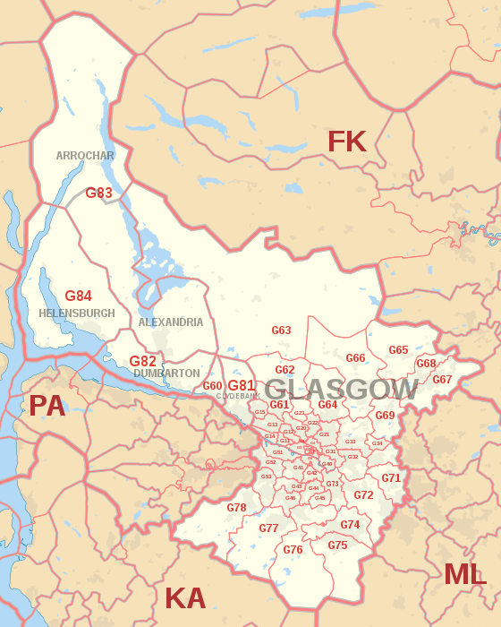
| G60 | GLASGOW | Bowling, Old Kilpatrick | West Dunbartonshire |
|---|
| G61 | GLASGOW | Bearsden | East Dunbartonshire |
|---|
| G62 | GLASGOW | Baldernock, Milngavie, Mugdock | East Dunbartonshire, Stirling |
|---|
| G63 | GLASGOW | Balfron, Balmaha, Blanefield, Croftamie, Drymen, Dumgoyne, Fintry, Killearn, Rowardennan, Strathblane | Stirling |
|---|
| G64 | GLASGOW | Bishopbriggs, Torrance | East Dunbartonshire |
|---|
| G65 | GLASGOW | Croy, Kilsyth, Twechar | North Lanarkshire, East Dunbartonshire |
|---|
| G66 | GLASGOW | Clachan of Campsie, Haughhead, Kirkintilloch, Lennoxtown, Lenzie, Milton of Campsie, Auchinloch | East Dunbartonshire, North Lanarkshire |
|---|
| G67 | GLASGOW | Cumbernauld (south) | North Lanarkshire |
|---|
| G68 | GLASGOW | Cumbernauld (north), Dullatur | North Lanarkshire, very small part of Falkirk |
|---|
| G69 | GLASGOW | Baillieston, Bargeddie, Chryston, Garrowhill, Gartcosh, Gartloch, Moodiesburn, Muirhead, Springhill | Glasgow City, North Lanarkshire |
|---|
| G70 | GLASGOW | HM Revenue and Customs, Cumbernauld | non-geographic |
|---|
| G71 | GLASGOW | Birkenshaw, Bothwell, Broomhouse, Tannochside, Uddingston, Viewpark | Glasgow City, North Lanarkshire, South Lanarkshire |
|---|
| G72 | GLASGOW | Blantyre, Cambuslang | South Lanarkshire |
|---|
| G73 | GLASGOW | Rutherglen | South Lanarkshire |
|---|
| G74 | GLASGOW | East Kilbride (north), Thorntonhall | South Lanarkshire |
|---|
| G75 | GLASGOW | Auldhouse, East Kilbride (south) | South Lanarkshire |
|---|
| G76 | GLASGOW | Busby, Carmunnock, Clarkston, Eaglesham, Waterfoot | East Renfrewshire, Glasgow City, very small parts of South Lanarkshire |
|---|
| G77 | GLASGOW | Newton Mearns | East Renfrewshire |
|---|
| G78 | GLASGOW | Barrhead, Neilston, Uplawmoor | East Renfrewshire, very small parts of East Ayrshire and North Ayrshire |
|---|
| G79 | GLASGOW | HM Revenue and Customs, East Kilbride | non-geographic |
|---|
| G81 | CLYDEBANK | Dalmuir, Duntocher, Faifley, Hardgate | West Dunbartonshire |
|---|
| G82 | DUMBARTON | Cardross, Milton, Renton | West Dunbartonshire, Argyll and Bute |
|---|
| G83 | ALEXANDRIA; ARROCHAR | Alexandria, Arrochar, Aldochlay, Ardlui, Balloch, Bonhill, Gartocharn, Inverarnan, Jamestown, Luss, Tarbet | West Dunbartonshire, Argyll and Bute, Stirling |
|---|
| G84 | HELENSBURGH | Clynder, Cove, Garelochhead, Kilcreggan, Rhu, Rosneath, Shandon | Argyll and Bute |
|---|
| G90 | GLASGOW | Department for Work and Pensions | non-geographic |
|---|