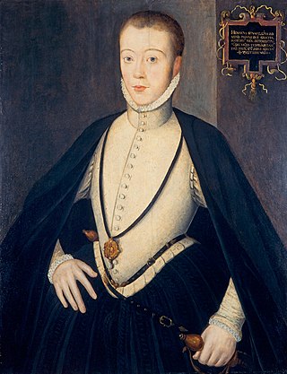
Darnley

Last updated

Darnley
Flats on Glen Clunie Place (geograph 5844286).jpg
The Glen Clunie Place block is the main remnant from the original Darnley development
Glasgow UK location map.svg
Red pog.svg
Darnley
Location within Glasgow
OS grid reference NS534597
Council area
Lieutenancy area
  • Glasgow
Country Scotland
Sovereign state United Kingdom
Post town GLASGOW
Postcode district G53 7
Dialling code 0141
Police Scotland
Fire Scottish
Ambulance Scottish
UK Parliament
Scottish Parliament
List of places
UK
Scotland
Glasgow
55°48′32″N4°20′26″W / 55.808943°N 4.340692°W / 55.808943; -4.340692 Coordinates: 55°48′32″N4°20′26″W / 55.808943°N 4.340692°W / 55.808943; -4.340692 ,

Darnley is an area in south-west Glasgow, Scotland, on the A727 just west of Arden (the areas are separated by the M77 motorway although a footbridge connects them). Other nearby neighbourhoods are Priesthill to the north, Southpark Village to the south, and South Nitshill and Parkhouse to the west; there is also a small industrial estate. The closest railway station is Priesthill and Darnley. The Brock Burn flows through the area.

Contents

History

The historic estate of Darnley (anciently Derneley, etc.), in Eastwood parish, Renfrewshire, 1.5 mi (2.4 km) east of Barrhead, was the seat of an ancient barony. [1]

In 1356, Robert Stewart, High Steward of Scotland, granted the barony to Sir John Stewart. It remained a possession of this branch of the house of Stewart (known as "Stewart of Darnley"), and in 1460 Sir John Stewart of Darnley (d. 1495) became "Lord Darnley" (a Scottish Lordship of Parliament) and subsequently in 1488 he was created Earl of Lennox (2nd creation).

His descendant in the fourth generation was Henry Stewart, Lord Darnley (1546–67), the second but eldest surviving son of Matthew Stewart, 4th Earl of Lennox, (the courtesy title "Lord Darnley", his father's subsidiary title, designating him as heir apparent to the Earldom of Lennox), and the husband of Mary Queen of Scots by whom he was the father of King James VI of Scotland, I of England.

The title Earl of Darnley has been created twice. The 1675 creation was as a subsidiary title for Charles Lennox, 1st Duke of Richmond, 1st Duke of Lennox (1672-1723), of Goodwood House in Sussex, an illegitimate son of King Charles II, who in the early 18th century sold the estate of Darnley to the Duke of Montrose. [1] It was sold again in 1757 to Sir John Maxwell of Pollok, and in 1884 belonged to Stirling-Maxwell of Pollok and Keir, at which time it gave a prefix name to several seats of manufacture and other localities within its limits. [1]

During the second half of the 20th century, Darnley experienced total transformation from being a modest semi-rural community [2] [3] to becoming a significant part of Glasgow's response to a post-war housing shortage. Following the construction of large housing schemes at South Nitshill (1957) and Kennishead (1966), the City of Glasgow approved the building of 2,048 homes in Darnley in 1968. [4] This scheme was to occupy an area to the north of Nitshill Road covered by Leggatston Farm, part of the original Darnley estate taken within the City of Glasgow boundaries in 1938. [5]

Over three phases a total of 1,336 deck-access apartments, in blocks ranging in height from between two and seven stories and with inter-linking pedestrian access corridors, were built. [6] [4] This fell short of the initial number planned owing to a combination of economic, political and management setbacks. It was intended that Darnley would be a largely self-supporting estate and for this reason, two primary schools and a community centre formed part of the Council's plans. A social club and bowling green, a church, a small shopping centre and a library were all added throughout the 1970s. [5] Most of the original 1970s deck-access housing, which by the late 1990s had become dilapidated and increasingly abandoned, was demolished and replaced by a smaller quantity of modest individual houses with the remaining blocks refurbished. The present housing stock is managed by Glen Oaks Housing Association which was founded in 1991 and later expanded its scope to include regeneration projects in nearby Arden and Pollok as well as more recent developments at Southpark and Regents Park (north of Carnwadric). [7]

The broadening of the A726 to dual carriageway status in 1983 heralded the development of the Nitshill corridor as a light industrial and retail location. Darnley Trading Estate and large retail outlets are clustered around Junction 3 of the southward extension of the M77 motorway (completed in 1997). [5] The closure of Darnley Hospital in 1992 [8] and the opening on the site of a £3 million 120-bed nursing home in 1993 also altered the employment opportunities for the local population and has become symptomatic of the regeneration of modern Darnley. However, there is a huge retail area with large chain stores, including a Sainsbury's supermarket (the first in Scotland, dating from 1992). [9]

The Darnley plane tree

Mary Queen of Scots is said to have nursed her sick husband, Henry Stewart, Lord Darnley, under this "plane tree" (actually acer pseudoplatanus, sycamore tree); it must therefore have been mature in the 1560s as Darnley died in 1567 DarnleySycamore.JPG
Mary Queen of Scots is said to have nursed her sick husband, Henry Stewart, Lord Darnley, under this "plane tree" (actually acer pseudoplatanus, sycamore tree); it must therefore have been mature in the 1560s as Darnley died in 1567

Mary, Queen of Scots came to Glasgow early in 1567, having left Holyrood Palace in Edinburgh on 24 January to collect her husband, Lord Darnley. Darnley had reportedly contracted smallpox and the Queen intended to bring him back to Holyrood on a litter as he was too weak to ride a horse. Darnley returned with his wife, only to be murdered a few days later on 10 February. [10] [11]

Recent development

A £20 million refit and extension programme of Sainsburys began in February 2010; work included raising the store from 44,000sqft to 89,000sqft, constructing a mezzanine floor at the Nitshill Road side, a new petrol station and double-deck car parking area.

The new petrol station opened on 20 August 2010, the first in the company to have green-energy solutions such as solar energy panels and rain-water recycling for its car wash. The store was opened on 29 September 2010, by all 17 of the long-term employees who had been there since its initial opening in 1991. The store will become the Sainsbury's flagship store in Scotland again.

See also

Related Research Articles

Nitshill Human settlement in Scotland

Nitshill is a district on the south side of Glasgow. It is bordered by South Nitshill to the south, Darnley to the east, Crookston and Roughmussel to the north-west, Hurlet to the west and Househillwood and Priesthill to the north, with the Pollok district and the Silverburn Centre beyond. An area of open ground to the south-west of Nitshill forms the boundary between Glasgow and the town of Barrhead in East Renfrewshire.

Pollok Human settlement in Scotland

Pollok is a large housing estate on the south-western side of the city of Glasgow, Scotland. The estate was built either side of World War II to house families from the overcrowded inner city. Housing 30,000 at its peak, its population has since declined due to the replacement of substandard housing with lower-density accommodation.

Crookston Castle

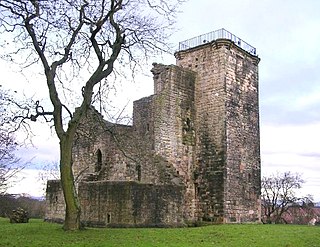
Crookston Castle is a ruined medieval castle in the Pollok area of Glasgow, Scotland. It is located some 5 miles (8 km) south-west of the city centre, on a hill overlooking the Levern Water, just before its confluence with the White Cart Water. Crookston Castle was built by the Stewarts of Darnley around 1400, and is set within earthworks constructed in the 12th century. Once the property of the Earls and Dukes of Lennox, the castle was extensively repaired following a siege in 1544, and it is the only surviving medieval castle in Glasgow.

Southpark Village Human settlement in Scotland

Southpark Village is a housing estate in the Darnley area of the Scottish city of Glasgow. The northwestern area was built during the mid to late 1980s, but the southeastern part was built in the late 2010s. It is located on the south-western edge of the city, close to the towns of Barrhead and Newton Mearns in East Renfrewshire. Nearby areas within Glasgow itself are the rest of Darnley to the north, Deaconsbank to the east, and Parkhouse to the northwest, although Southpark is physically separated from all but the rest of Darnley by the Dams to Darnley Country Park and M77 motorway.

Crookston, Glasgow Suburb of Glasgow, Scotland

Crookston is a residential suburb on the southwestern edge of the city of Glasgow, Scotland.

Arden, Glasgow Human settlement in Scotland

Arden is a medium-sized housing estate on the south-western edge of the city of Glasgow, Scotland. The M77 motorway runs directly to the west of the neighbourhood, with Junction 3 serving the area; a small industrial estate is located to the south-east. The residential area of Carnwadric is to the north-east of Arden, and the Jenny Lind part of Deaconsbank to the south, while the land to the north is open ground and woodland.

Priesthill Human settlement in Scotland

Priesthill is a neighbourhood in the south of the River Clyde in the Scottish city of Glasgow. It falls under the Greater Pollok ward of the city council area. The Darnley neighbourhood is located to the south, on the opposite side of the Glasgow South Western Line railway, while Nitshill lies to the west and Househillwood and the Silverburn Centre shopping complex to the north. The M77 motorway runs to the east of Priesthill with open farmland beyond.

South Nitshill Human settlement in Scotland

South Nitshill is a neighbourhood in the Scottish city of Glasgow. It is situated south of the River Clyde, in the south-west of the conurbation and within the Greater Pollok ward of the local authority area. All streets in the area have names beginning with 'W'.

Renfrewshire (historic) Historic county and lieutenancy area of western Scotland

Renfrewshire or the County of Renfrew is a historic county, registration county and lieutenancy area in the west central Lowlands of Scotland. It contains the local government council areas of Inverclyde, Renfrewshire and East Renfrewshire, as well as parts of Glasgow and is occasionally named Greater Renfrewshire to distinguish the county from the modern council area.

Stewart of Darnley was a notable Scots family, a branch of the Clan Stewart, who provided the English Stuart monarchs with their male-line Stuart descent, after the reunion of their branch with the royal Scottish branch, which led to the ultimate union of the two main kingdoms of Great Britain: England and Scotland.

Clan Lennox Lowland Scottish clan

Clan Lennox is a Lowland Scottish clan. The clan chiefs were the original Earls of Lennox, although this title went via an heiress to other noble families in the fifteenth and sixteenth centuries. The chiefship of the clan then went to the Lennox of Woodehead branch.

Deaconsbank Human settlement in Scotland

Deaconsbank is a neighbourhood in the Scottish city of Glasgow. It is situated south of the River Clyde. The main feature of the area, which falls into the Greater Pollok ward of Glasgow City Council and directly borders the East Renfrewshire council region, is an estate of around 639 private houses built in the late 1970s by Barratt Developments, prior to which the area was open farmland. Deaconsbank is bordered by the M77 motorway to the west and by Rouken Glen Park and golf course to the east. The northern parts of the suburban town of Newton Mearns are a short distance to the south, as is Patterton railway station.

Jenny Lind, Glasgow Human settlement in Scotland

Jenny Lind is a small neighbourhood in the Scottish city of Glasgow. It is situated south of the River Clyde, contiguous with the larger Deaconsbank neighbourhood and across a dual carriageway from the Arden and Thornliebank Industrial Estate. It was extended slightly in the 21st century by the addition of Jenny Lind Court. Jenny Lind falls under the Glasgow City Council Greater Pollok ward and has a short border with Deaconsbank Golf Club and Rouken Glen Park in the East Renfrewshire council region.

St Paul's High School is a co-educational, Roman Catholic comprehensive secondary school located in Pollok, Glasgow, Scotland. It was built on the site of, and using some buildings from, the former Craigbank Secondary School, to replace the previous Catholic school in the area, Bellarmine Secondary, opening with its new identity in 2002.

Greater Pollok (ward) Human settlement in Scotland

Greater Pollok is one of the 23 wards of Glasgow City Council. Since its creation in 2007 it has returned four council members, using the single transferable vote system.

Parkhouse, Glasgow G53 Human settlement in Scotland

Parkhouse is a residential neighbourhood of Glasgow, Scotland. Within the G53 postcode area and the Greater Pollok ward of the Glasgow City Council administration, the eastern cluster of private housing was constructed in the 1980s and the western part in the 2010s, prior to which it was open farmland annexed to Glasgow in 1938.

Dams to Darnley Country Park

Dams to Darnley Country Park is a 1350 acre country park in East Renfrewshire and Glasgow, in Scotland comprising the historic greenspace between the towns of Barrhead and Newton Mearns in East Renfrewshire, and the areas of Darnley, Parkhouse and Southpark Village in south Glasgow. Being designated since 2000, it is one of the newest country parks in Scotland.

Househillwood Area of Glasgow

Househillwood is a residential neighbourhood of Glasgow, Scotland, situated in the south-west of the city.

Darnley Lime Works Tramway and Mineral Railway

The Darnley Lime Works Tramway and Mineral Railway consisted of a narrow gauge field railway and probably a standard gauge works railway at today's Dams to Darnley Country Park in East Renfrewshire, 9.7 km southwest of Glasgow. They were successively operated at least from 1898 to 1959.

References

  1. 1 2 3 Frances Groome, Ordnance Gazetteer of Scotland, 1882-4
  2. Darnley Renfrewshire, Ordnance Gazetteer of Scotland, 1882 (Vision of Britain Through Time)
  3. Darnley Bleachfield and Upper Darnley (Pollok House, 1830), the Glasgow Story
  4. 1 2 Glasgow, Glen Clunie Drive, Darnley Development General View (1991), Canmore
  5. 1 2 3 Neighbourhoods: Darnley, The Glasgow Story
  6. Darnley Tenements (Mitchell Library, Glasgow Collection, 2004), the Glasgow Story
  7. Our History, Glen Oaks Housing Association Limited
  8. "Records of Darnley Hospital, Renfrewshire, Scotland" . Retrieved 13 April 2008.
  9. Analysis: How Oliver got an extra serving at Sainsbury's, The Scotsman, 30 May 2002
  10. Daniel, William S. (1852), History of The Abbey and Palace of Holyrood. Pub. Edinburgh: Duncan Anderson. pp. 83 – 84.
  11. Mary Stuart and Henry Stuart green plaque, Open Plaques 2009-2019