
Glasgow City Council is the local government authority for Glasgow City council area, Scotland. In its modern form it was created in 1996. Glasgow was formerly governed by a corporation, also known as the town council, from the granting of its first burgh charter in the 1170s until 1975. From 1975 until 1996 the city was governed by City of Glasgow District Council, a lower-tier authority within the Strathclyde region.

Lanarkshire, also called the County of Lanark, is a historic county, lieutenancy area and registration county in the Central Lowlands of Scotland. The county is no longer used for local government purposes, but gives its name to the two modern council areas of North Lanarkshire and South Lanarkshire.

Shettleston is an area in the east end of Glasgow in Scotland.
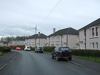
Cranhill is an inner city district and housing scheme in the north east of Glasgow, Scotland. Cranhill was developed from public funding in the early 1950s and was originally, chiefly composed of four-storey tenement blocks surrounding a patch of grassland, which became Cranhill Park. Later development saw the building of three tower blocks, surrounded by rows of terraced maisonettes. In more recent years, a number of semi-detached and detached homes have been built. The area also hosts some shops, two primary schools and nurseries, a community centre and the Cranhill water tower.

Craigton is a residential suburb in the southwest of the city of Glasgow, Scotland. Located approximately three miles from the city centre, it is bordered by Bellahouston Park to the south and Halfway to the west, with Cardonald beyond.

Barlanark is a district in the Scottish city of Glasgow. It is situated east of Budhill, Shettleston and Springboig, north west of Baillieston, west of Springhill and Swinton and south of Easthall, Easterhouse and Wellhouse.
Carntyne is a suburban district in the Scottish city of Glasgow. It is situated north of the River Clyde, and in the east end of the city. Since 2007 it has formed the core of the East Centre ward under Glasgow City Council, which also includes the neighbouring Riddrie and Cranhill areas.
Greenfield is a neighbourhood in the east end of the Scottish city of Glasgow, north of the River Clyde. The estate was built on the grounds of Greenfield House which was demolished to make way for the new scheme which was built in the 1960s.

Queenslie is a district in the Scottish city of Glasgow.
Sandyhills is an area of the Scottish city of Glasgow. It is situated north of the River Clyde and has fallen within the Shettleston ward of Glasgow City Council since 2007.
Glasgow Baillieston was a burgh constituency of the House of Commons of the Parliament of the United Kingdom. It elected one Member of Parliament (MP) using the first-past-the-post voting system.

Glasgow Baillieston was a constituency of the Scottish Parliament (Holyrood). It elected one Member of the Scottish Parliament (MSP) by the plurality method of election. The seat was represented by Labour's Margaret Curran from the inception of the Scottish Parliament in 1999 until her retirement in 2011.
Lilybank is a neighbourhood in the east of Glasgow, Scotland. Neighbouring areas Newbank to the west, Braidfauld to the east and the eastern part of Parkhead to the north. The A74 London Road runs to the south, with the land on the opposite side between the road and the River Clyde not used for residential purposes: the Barrowfield football training ground owned by Celtic F.C., and the Dewar's whisky bottling plant and warehouses, the latter on the former Westthorn country estate.

Springhill is a district in the Scottish city of Glasgow. It is situated north of the River Clyde on the eastern edge of the city, north of the areas of Baillieston and Garrowhill and west of Swinton.

Wellhouse is a residential neighbourhood in the East End of the Scottish city of Glasgow. Since 2007 it has been part of the Baillieston administrative ward within the Glasgow City Council area.
St Andrew's Secondary School is an 11–18 mixed, Roman Catholic comprehensive secondary school in Glasgow, Scotland. Its catchment area includes much of the East End of the city, including such districts as Baillieston, Craigend, Cranhill, Easterhouse, Greenfield, Shettleston, Tollcross and Wellhouse.

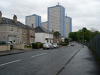
Broomhouse is a residential area in Glasgow, Scotland. It is about 6 miles (10 km) east of the city centre. Historically a small mining village and later the site of the Glasgow Zoo, in the early 21st century it grew substantially as an affluent commuter suburb.

East Centre is one of the 23 wards of Glasgow City Council. On its creation in 2007 and in 2012 it returned four council members, using the single transferable vote system. For the 2017 Glasgow City Council election, the boundaries were changed, but four members were still returned.

Baillieston is one of the 23 wards of Glasgow City Council. On its creation in 2007 and in 2012 it returned four council members, using the single transferable vote system. For the 2017 Glasgow City Council election, the boundaries were changed: the ward decreased in size and population, and returned three members.


