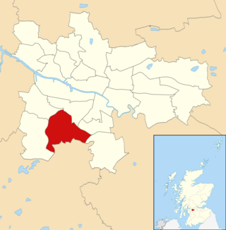
Arden is a medium-sized housing estate on the south-western edge of the city of Glasgow, Scotland. The M77 motorway runs directly to the west of the neighbourhood, with Junction 3 serving the area; a small industrial estate is located to the south-east (this falls within Glasgow although is named after the neighbouring settlement of Thornliebank in East Renfrewshire).[1] The residential area of Carnwadric is to the north-east of Arden, and the Jenny Lind part of Deaconsbank to the south, while the land to the north is open ground (formerly Kennishead Farm) and woodland.
Historically, Arden was a farm[2] and formed part of Sir John Maxwell's land, one of approximately seven adjoining holdings which were situated on ancient Stewart land, originally granted to Walter Stewart, 6th High Steward of Scotland by Robert the Bruce upon his marriage to Marjorie Bruce, the King's eldest daughter. Arden is near Thornliebank, a village formed on the river to manufacture cloth[3] and a specialized printing of cloth known as beetling; Thornliebank linen was quite famous from the early-nineteenth century until the closure of the mill, in or around 1920. The building adjoining part of what is now Arden was used as a Prisoner of War (POW) camp during the Second World War.
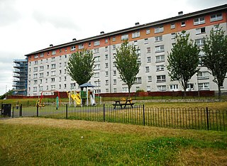
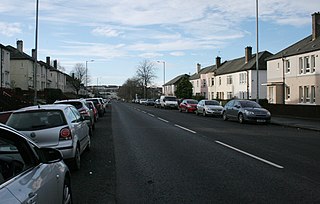
The S.S.H.A (Scottish Special Housing Association) built the estate (consisting mostly of four-storey tenements with a common close entrance) between 1953 and 1957 to rehouse families from the old, overcrowded inner city tenements.[4][5] Arden became very run-down during the 1970s and 1980s, with grants made for its refurbishment. It is not quite completed[when?] but is much improved. The shopping area containing around six businesses is in immediate need of investment and refurbishment. In 1999, the estate was bought by Glen Oaks Housing Association for a rumoured £6 million but the association has since acknowledged this may have been a rather inflated sum, and they have struggled to make necessary repairs as they are funded only by rents.
Amenities
Arden became the first housing scheme to have a public house (The Cuillins) privately built in 1964-5 which then became a brewery pub in 1968.
Arden boasts the new Ashpark Primary School which opened on 2 December 2008 and replaced the former Arden Primary School and Carnwadric Primary School. The second school, St. Louise Primary was merged with the newly rebuilt St. Vincent's Primary in Carnwadric, St. Louise's closed in June 2009 and the buildings subsequently demolished.
The nearest railway station is Kennishead, named after another of Sir John Maxwell's farms.
In popular culture
Arden featured in the documentary programme Colin and Justin on the Estate[6] which looked at the efforts to improve the area. Some of the current and former residents of Arden, were concerned about the slant of the show, and were particularly annoyed by the fact that the producers of the show concentrated their attention on housing units that were scheduled for demolition and not on housing that had seen extensive and successful renovation. Alasdair McKee, Glen Oaks chief executive, concluded however, that the program was a success and "the improvements have helped to convince people that we can make a difference" and contributed to a waiting list of people wanting to get into the estate.[7]
Social deprivation
Over the years, the area has gained a reputation as a well documented centre of social deprivation, particularly the southern area near Nitshill Road. The life expectancy for males in this part of the city is around 60 years, as a result of the 'Glasgow effect'.[8]
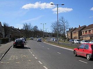
Gallery
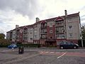
Housing. 95-97 Kyleakin Road.
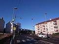
Housing. Carnwadric Road.
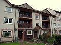
Housing. 1 Kilmiur Road.
Housing. 72-74 Kyleakin Road.
Polish Shop "Varsovia". 9 Kilmaluag Terrace.
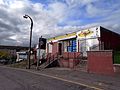
Shops between Kilmaluag Terrace and Kyleakin Road.
Nitshill is a district on the south side of Glasgow. It is bordered by South Nitshill to the south, Darnley to the east, Crookston and Roughmussel to the north-west, Hurlet to the west and Househillwood and Priesthill to the north, with the Pollok district and the Silverburn Centre beyond. An area of open ground to the south-west of Nitshill forms the boundary between Glasgow and the town of Barrhead in East Renfrewshire.
Pollok is a large housing estate on the south-western side of the city of Glasgow, Scotland. The estate was built either side of World War II to house families from the overcrowded inner city. Housing 30,000 at its peak, its population has since declined due to the replacement of substandard housing with lower-density accommodation. As of 2021, the population was recorded at 81,951 people.
Pollokshields is an area in the Southside of Glasgow, Scotland. Its modern boundaries are largely man-made, being formed by the M77 motorway to the west and northwest with the open land of Pollok Country Park and the Dumbreck neighbourhood beyond, by the Inverclyde Line railway and other branches which separate its territory from the largely industrial areas of Kinning Park, Kingston and Port Eglinton, and by the Glasgow South Western Line running from the east to south, bordering Govanhill, Strathbungo, Crossmyloof and Shawlands residential areas. There is also a suburban railway running through the area.
Shawlands is a Southside suburb of Glasgow, Scotland, located two miles south of the River Clyde. The area, considered the "Heart of the Southside", is known for its independent restaurants and cafés, art scene, public parks, period terraces, and red and blond sandstone tenements. Shawlands was named one of the best places to live in Scotland in 2022 and 2023 by The Sunday Times, and one of the world's coolest neighbourhoods by Time Out Magazine with judges describing it as "the city's best area to live and socialise”. It is located between Pollok Country Park, the home of the Burrell Collection and Pollok House, and the acclaimed Victorian park Queen's Park.
Strathbungo is a mainly residential area of southern Glasgow, Scotland, bordered by the neighbourhoods of Crossmyloof to the south, Govanhill to the east and Pollokshields to the north and west. The settlement grew up as a small isolated village built along the Pollokshaws Road, one of the main arteries leading southwards from the centre of Glasgow, adjoined by the Camphill Estate, now part of Queens Park. Strathbungo lay just inside Govan parish, on its boundary with Cathcart parish, and at one time a line just north of Allison Street and Nithsdale Street formed the boundary or 'march' between the counties of Lanark and Renfrew.
Crookston is a residential suburb on the southwestern edge of the city of Glasgow, Scotland.
Darnley is an area in south-west Glasgow, Scotland, on the A727 just west of Arden. Other nearby neighbourhoods are Priesthill to the north, Southpark Village to the south, and South Nitshill and Parkhouse to the west; there is also a small industrial estate. The closest railway station is Priesthill and Darnley. The Brock Burn flows through the area.
Thornliebank is a suburban area in East Renfrewshire, in the west central Lowlands of Scotland. Part of the Greater Glasgow conurbation, it is located on the Auldhouse Burn about six miles south of Glasgow city centre, and just outside the city's administrative boundaries. The neighbouring East Renfrewshire town of Giffnock lies directly to the east, with Rouken Glen Park to the south.
Cowglen is a district in the Scottish city of Glasgow, within the Newlands/Auldburn ward of the city but geographically closer to the large suburb of Pollok. It is situated south of the River Clyde. Much of its territory is open land occupied by a golf course, and it also adjoins Pollok Country Park.
Carnwadric is a residential area of Glasgow, Scotland. It is situated south of the River Clyde, and is bordered by a park to the north, the Arden housing estate to the west, by the village of Thornliebank to the south and by the Auldhouse Burn to the east.
Priesthill is a neighbourhood in the south of the River Clyde in the Scottish city of Glasgow. It falls under the Greater Pollok ward of the city council area. The Darnley neighbourhood is located to the south, on the opposite side of the Glasgow South Western Line railway, while Nitshill lies to the west and Househillwood and the Silverburn Centre shopping complex to the north. The M77 motorway runs to the east of Priesthill with open farmland beyond.
South Nitshill is a neighbourhood in the Scottish city of Glasgow. It is situated south of the River Clyde, in the south-west of the conurbation and within the Greater Pollok ward of the local authority area. All streets in the area have names beginning with 'W'.
Mansewood is a residential district in the Scottish city of Glasgow. It is situated south of the River Clyde and is surrounded by the districts of Eastwood, Hillpark, Pollokshaws in Glasgow, and Thornliebank and Giffnock in East Renfrewshire.
Kennishead is a neighbourhood in the Scottish city of Glasgow. Its territory, south of the River Clyde, is fairly isolated, bordering a park to the south and a golf course to the north, as well as the residential area of Carnwadric. The majority of the housing consists of three high rise tower blocks of 23 storeys, which dominate the area visually.
Deaconsbank is a neighbourhood in the Scottish city of Glasgow. It is situated south of the River Clyde. The main feature of the area, which falls into the Greater Pollok ward of Glasgow City Council and directly borders the East Renfrewshire council region, is an estate of around 639 private houses built in the late 1970s by Barratt Developments, prior to which the area was open farmland. Deaconsbank is bordered by the M77 motorway to the west and by Rouken Glen Park and golf course to the east. The northern parts of the suburban town of Newton Mearns are a short distance to the south, as is Patterton railway station.
Jenny Lind is a small neighbourhood in the Scottish city of Glasgow. It is situated south of the River Clyde, contiguous with the larger Deaconsbank neighbourhood and across a dual carriageway from the Arden and Thornliebank Industrial Estate. It was extended slightly in the 21st century by the addition of Jenny Lind Court. Jenny Lind falls under the Glasgow City Council Greater Pollok ward and has a short border with Deaconsbank Golf Club and Rouken Glen Park in the East Renfrewshire council region.
Glasgow, the largest city in Scotland, has several distinct styles of residential buildings. Building styles reflect historical trends, such as rapid population growth in the 18th and 19th centuries, deindustrialisation and growing poverty in the late 20th century, and civic rebound in the 21st century.
Calderwood is a neighbourhood of the Scottish new town of East Kilbride, in South Lanarkshire. It lies on its north-east edge and is one of the largest areas of the town.
Newlands/Auldburn is one of the 23 wards of Glasgow City Council. Situated south of the city and the River Clyde, it is represented by 3 members as of May 2022, one each from the Scottish National Party, Scottish Labour, and Scottish Green Party.
Eastwood is a residential neighbourhood in the city of Glasgow, Scotland. It is situated south of the River Clyde, and is part of the Newlands/Auldburn ward under Glasgow City Council.
This page is based on this Wikipedia article Text is available under the CC BY-SA 4.0 license; additional terms may apply. Images, videos and audio are available under their respective licenses.