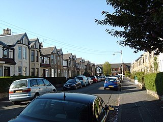
Jordanhill is an affluent area of the West End of the city of Glasgow, Scotland. The area consists largely of terraced housing dating from the early to mid 20th century, with some detached and semi-detached homes and some modern apartments.
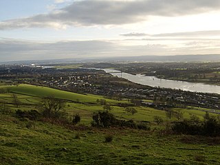
Clydebank is a town in West Dunbartonshire, Scotland. Situated on the north bank of the River Clyde, it borders the village of Old Kilpatrick to the west, and the Yoker and Drumchapel areas of the adjacent City of Glasgow immediately to the east. Depending on the definition of the town's boundaries, the suburban areas of Duntocher, Faifley and Hardgate either surround Clydebank to the north, or are its northern outskirts, with the Kilpatrick Hills beyond.
Bearsden is a town in East Dunbartonshire, Scotland, on the northwestern fringe of Greater Glasgow, approximately six miles from the city centre.

Scotstoun is an area of Glasgow, Scotland, west of Glasgow City Centre. It is bounded by Garscadden and Yoker to the west, Victoria Park, Jordanhill and Whiteinch to the east, Jordanhill to the north and the River Clyde to the south. At the heart of Scotstoun lies Scotstounhill, an enclave of late Victorian and post-war housing centred on Scotstounhill railway station. Scotstoun is home to BAE Systems Surface Ships, and to the Glasgow Warriors rugby team.

Knightswood is a suburban district in Glasgow, containing three areas: Knightswood North or High Knightswood, Knightswood South or Low Knightswood, and Knightswood Park. It has a golf course and park, and good transport links with the rest of the city. Garscadden and Scotstounhill railway stations serve Low Knightswood while Westerton station serves High Knightswood. Knightswood is directly adjoined by the Anniesland, Blairdardie, Drumchapel, Garscadden, Jordanhill, Netherton, Scotstoun, Scotstounhill and Yoker areas of Glasgow, and by Bearsden in the north.

Kelvindale is a district in the West End of the city of Glasgow, Scotland. Kelvindale shares the G12 postcode with the neighbouring residential districts of Kelvinside, Hillhead, Hyndland, Dowanhill, as well as Gartnavel General Hospital, Glasgow Clyde College (Anniesland) and the University of Glasgow, and is also close to the Anniesland and Wyndford areas of the city. The area is characterised by traditional interwar housing, formed of tenements and semi-detached houses.
Wishaw is a large town in North Lanarkshire, Scotland, on the edge of the Clyde Valley, 15 miles (24 km) south-east of Glasgow city centre.

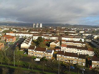
Drumchapel, known locally as 'The Drum', is a district in the north-west of the city of Glasgow, Scotland. It borders Bearsden to the north-east and Drumry to the south-west, as well as Blairdardie, Garscadden, Knightswood and Yoker in Glasgow to the south; land to the north is undeveloped and includes the course of the Roman-era Antonine Wall. The name derives from the Gaelic meaning 'the ridge of the horse'.

Old Kilpatrick, is a village in West Dunbartonshire, Scotland. The name Old Kilpatrick is said to be derived from St. Patrick ostensibly being born here. It has an estimated population of 4,820. It belonged to the parish of Old Kilpatrick which itself was only a few thousand people strong.

Anniesland is a district in the West End of the Scottish city Glasgow. It is situated north of the River Clyde, and centres on the major road junction of the Great Western Road (A82) and Crow Road/Bearsden Road (A739), known as Anniesland Cross.

Broomhill is a district in the West End of the city of Glasgow, Scotland. North of the River Clyde, it is bounded by the districts of Thornwood and Partick to the south, Hyndland to the east, and Jordanhill, Scotstoun and Victoria Park to the west.
Blairdardie is a neighbourhood in the Scottish city of Glasgow. It is situated north of the River Clyde in the north-west of the city and is surrounded by other residential areas: High Knightswood, Knightswood, Old Drumchapel, Drumchapel and Garscadden. It was built between the 1950s and early 1960s.

Bowling is a village in West Dunbartonshire, Scotland, with a population of 740 (2015).

Dalmuir is an area nine miles northwest of Glasgow, Scotland, on the western side of Clydebank, and part of West Dunbartonshire Council Area. The name is a lowland Scots derivation of the Gaelic meaning Big Field. The area was originally two separate villages with Dalmuir Shore joining with Clydebank in 1886 and Dalmuir Village in 1906, during a period of rapid industrialisation and expansion. Dalmuir is bounded by the village of Old Kilpatrick to the west, the Mountblow and Parkhall housing schemes to the north, and the Clydebank town centre area to the east. To the south is the River Clyde.
New Kilpatrick, is an ecclesiastical Parish and former Civil Parish in Dunbartonshire. It was formed in 1649 from the eastern half of the parish of Kilpatrick, the western half forming Old Kilpatrick. New Kilpatrick is also a disused name for the town of Bearsden.

Knightswood St. Margaret's Parish Church is a parish church of the Church of Scotland, serving part of the Knightswood area of Glasgow, Scotland.

Netherton is a district of Glasgow, in the north of the city, bounded by Temple to the south, Knightswood to the west while Westerton in Bearsden lies to the North and East. Netherton appears in Joan Blaeu's 1662 Atlas of Scotland and many subsequent old maps. It is currently not shown on Ordnance Survey maps greater than 1:25000 scale. The street was founded in around the 1930s. It is a street close by local shops, the hut, and a park district. Part of the city council.
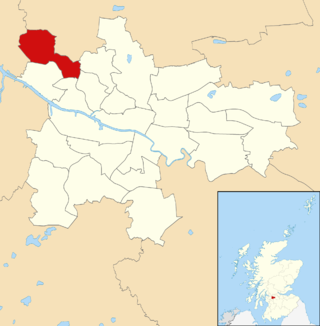
Drumchapel/Anniesland is one of the 23 wards of Glasgow City Council. Since its creation in 2007 it has retained the same boundaries and returned four council members, using the single transferable vote system.

Cadder is a neighbourhood in the north of Glasgow, Scotland. Within the Canal ward under Glasgow City Council, historically more closely associated with the Lambhill and Maryhill districts, it is located 5 kilometres (3 mi) north of Glasgow city centre, sited on the route of the Forth and Clyde Canal. Occupying a footprint which is around 800 metres (870 yd) east to west but only 200 metres (220 yd) north to south on a fairly steep incline, the neighbourhood was built in the early 1950s and borders Glasgow Western Necropolis & Crematorium, Lambhill Cemetery and St. Kentigern's RC Cemetery, as well as Possil Marsh at its eastern side.


