
Lanarkshire, also called the County of Lanark, is an historic county, lieutenancy area and registration county in the central Lowlands of Scotland.

Rutherglen is a town in South Lanarkshire, Scotland, located immediately south-east of the city of Glasgow – 3 miles (4.8 km) from its centre – and directly south of the River Clyde. Having existed as a Lanarkshire burgh in its own right for more than 800 years, in 1975 Rutherglen lost its own local council and administratively became a component of the City of Glasgow District Council within the Strathclyde region. In 1996 the towns were reallocated to the South Lanarkshire council area.

Motherwell is a large town and former burgh in North Lanarkshire, Scotland, United Kingdom, south east of Glasgow. It has a population of around 32,120. Historically in the parish of Dalziel and part of Lanarkshire, Motherwell is the headquarters for North Lanarkshire Council. Geographically the River Clyde separates Motherwell from Hamilton to the west whereas the South Calder Water separates Motherwell from Carfin to the north-east and New Stevenston and Bellshill towards the north.

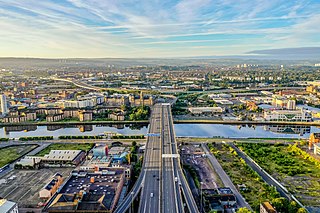
The M80 is a motorway in Scotland's central belt, running between Glasgow and Stirling via Cumbernauld and Denny and linking the M8, M73 and M9 motorways. Following completion in 2011, the motorway is 25 miles (40 km) long. Despite being only a two lane motorway, parts of the M80 Stepps Bypass are used by around 60,000 vehicles per day.

Wishaw is a large town in North Lanarkshire, Scotland, on the edge of the Clyde Valley, 15 miles (24 km) south-east of Glasgow city centre. The Burgh of Wishaw was formed in 1855 within Lanarkshire. it formed a joint large burgh with its neighbour Motherwell from 1920 until its dissolution when Scottish local authorities were restructured in 1975, and was then in Motherwell district within the Strathclyde region until 1996. The town is part of the Motherwell and Wishaw constituency. It has the postal code of ML2 and the dialling code 01698.

Cleland is a village near Motherwell and Wishaw in North Lanarkshire, Scotland. As of 2018, it has a population of about 3,000. The village has a strong coal mining heritage, and is a typical example of a working class village in North Lanarkshire and the Glasgow area. Due to its location, despite being at the heart of North Lanarkshire, the village is isolated, geographically and culturally, from surrounding towns such as Motherwell, Shotts and Wishaw.
The city of Glasgow, Scotland has a transport system encompassing air, rail, road, and an underground rail line. Prior to 1962, the city was also served by trams. Commuters travelling into Glasgow from the neighbouring local authorities of North and South Lanarkshire, Renfrewshire, East Renfrewshire, and East and West Dunbartonshire have a major influence on travel patterns, with tens of thousands of residents commuting into the city each day. The most popular mode of transport in the city is the car, used by two thirds of people for journeys around the city.

Robroyston is a suburb of Glasgow, Scotland, located around 3 miles (5 km) north-east of the city centre.

Uddingston is a small town in South Lanarkshire, Scotland. It is on the north side of the River Clyde, south-east of Glasgow city centre, and acts as a dormitory suburb for the city.

Cranhill is an inner city district and housing scheme in the north east of Glasgow, Scotland. Cranhill was developed from public funding in the early 1950s and was originally, chiefly composed of four-storey tenement blocks surrounding a patch of grassland, which became Cranhill Park. Later development saw the building of three tower blocks, surrounded by rows of terraced maisonettes. In more recent years, a number of semi-detached and detached homes have been built. The area also hosts some shops, two primary schools and nurseries, a community centre and the Cranhill water tower.

Hogganfield is a district in the Scottish city of Glasgow, located to the north east of the city centre. Hogganfield is surrounded by the Glasgow districts of Blackhill, Craigend, Millerston, Provanmill, Riddrie, Robroyston, Ruchazie and Stepps. The M80, Stepps bypass, separates Hogganfield from Robroyston.
Ruchazie is a neighbourhood in the Scottish city of Glasgow. It is situated to the north-east of the city, bordered by Craigend and Garthamlock to the east and the open ground of Hogganfield Park and Lethamhill Golf Course to the north. Ruchazie is separated from Cranhill to the south and Riddrie to the west by the M8 motorway, previously the route of the Monkland Canal.

Auchinloch is a village in Scotland, situated within the North Lanarkshire local authority area but very close to the boundary with East Dunbartonshire and sharing the G66 postcode of the town of Kirkintilloch and the adjoining village of Lenzie, located a short distance to the north. Other nearby settlements in North Lanarkshire are Stepps to the south and Chryston to the south-east, each approximately 1.3 miles (2.1 km) away across farmland and on the opposite side of the M80 motorway; the City of Glasgow boundary and the suburb of Robroyston is about the same distance to the west. In previous years Auchinloch was in the Parish of Cadder and, from 1975 until 1996, the district of Strathkelvin within Strathclyde Region.

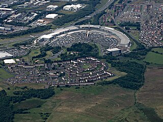
Stepps is a settlement in North Lanarkshire, Scotland, near the north-eastern outskirts of Glasgow. Its recently upgraded amenities include a new primary school, library and sports facilities. The town retains a historic heart around its church in Whitehill Avenue, whilst examples of Victorian and Edwardian housing can still be found. The travel connections by road and rail mean residents work in Glasgow, Edinburgh, Falkirk, Stirling and beyond. The town is located in close proximity to the new Seven Lochs Wetland Park, from which views to the Campsies and Loch Lomond can be enjoyed. Stepps has a population of around 6,730.

Gartcosh is a village in North Lanarkshire, Scotland. The village lies a few miles east of Glasgow, and about a mile northwest of the town of Coatbridge.

Cardowan is a suburb situated in North Lanarkshire, Scotland, on the north-eastern outskirts of Glasgow.

Newton is a mainly residential district in the town of Cambuslang in Scotland; it is situated directly south of the River Clyde. Newton is within the Cambuslang East ward of the South Lanarkshire Council area. Formerly a mining settlement from the mid-19th to mid-20th centuries then sparsely populated for several decades, in the early 2000s it was designated a 'Community Growth Area' for residential development with several hundred houses, a new primary school and associated infrastructure constructed in phases over several years into the 2020s, mostly on fields previously used by a farm which had operated for several centuries before closing around the turn of the 21st century.

Broomhouse is a residential area in Glasgow, Scotland. It is about 6 miles (10 km) east of the city centre. Historically a small mining village and later the site of the Glasgow Zoo, in the early 21st century it grew substantially as an affluent commuter suburb.
North East is one of the 23 wards of Glasgow City Council. On its creation in 2007 and in 2012 it returned four council members, using the single transferable vote system. For the 2017 Glasgow City Council election, the ward boundaries were redrawn with a smaller size and population, and it returned three members.
Stepps, Chryston and Muirhead is one of the twenty-one wards used to elect members of the North Lanarkshire Council. It currently elects three councillors and, as its name suggests, covers the settlements of Stepps, Chryston and Muirhead with a combined population of 12,290 in 2019.


