Tradeston

Last updated

Tradeston
Co-op building, Paisley road, Glasgow, Scotland, UK (33841234935).jpg
The former Glasgow headquarters of the Co-Operative and Wholesale Society on Morrison Street - one of Tradeston's most famous landmarks
Glasgow UK location map.svg
Red pog.svg
Tradeston
Location within Glasgow
OS grid reference NS581660
Council area
Lieutenancy area
  • Glasgow
Country Scotland
Sovereign state United Kingdom
Post town GLASGOW
Postcode district G5
Dialling code 0141
Police Scotland
Fire Scottish
Ambulance Scottish
UK Parliament
Scottish Parliament
List of places
UK
Scotland
Glasgow
55°51′11″N4°15′47″W / 55.85306°N 4.26306°W / 55.85306; -4.26306


Kingston House, a riverside warehouse in Tradeston dating from 1878 Riverside warehouse - geograph.org.uk - 1655945.jpg
Kingston House, a riverside warehouse in Tradeston dating from 1878

Tradeston (Scots : Tredstoun) is a small district in the Scottish city of Glasgow adjacent to the city centre on the south bank of the River Clyde. The name (a portmanteau of "Trades Town") reflected its role as a primarly dockland area with a large number of warehouses and wharves along the riverside were vessels would be unloaded. It merges to the south and west with Kingston, and the two districts are often considered one and the same.

Contents

By the middle of the 20th Century, most of this had disappeared, although remnants of the area's thriving trading industry had survived in its high concentration of wholesaler businesses, some of which are still in operation into the 21st Century. Today, Tradeston has become increasingly gentrified, with the city centre's financial district now expanding over to the south bank, heralding the arrival of new office and residential developments.

Geography

Tradeston borders with Laurieston and the Gorbals to its immediate east, Pollokshields to the south and Kingston to the west, therefore its notional boundaries are the River Clyde to the north, the Glasgow to Paisley railway line to the south, Eglinton Street and Bridge Street to the east and West Street to the west. The M74 Extension traverses the area.

The Tradeston Bridge, opened on 14 May 2009, links Tradeston and neighbouring Kingston with Broomielaw and the city's International Financial Services District for pedestrians and cyclists.

Economy and Architecture

Tradeston's historical role as a centre for warehousing and trade is symbolised by its grandest and most famous building - 95 Morrison Street - which was constructed as Co-Operative House; the headquarters of CWS Scotland - a role which it maintained well into the late 20th Century. It was designed by architects Bruce and Hay and built between 1893-97 as the head office of the Scottish Co-operative Wholesale Society. A famous urban myth persists that it was one of the rejected designs for Glasgow City Chambers which was constructed on George Square so similar are the two buildings' basic appearance. The building has since been converted for residential use.

Tradeston's role as a hub for trade continued well into the late 20th century, as a large number of wholesaler (Cash and Carry) businesses continued to be located in the area, although some of these have gradually closed down or have opened as retailers to the general public as a higher residential population has now moved into the area.

Many former industrial buildings in the area were demolished as part of the M74 Extension which opened in June 2011. Barclays Bank opened a new headquarters at the Tradeston waterfront on the River Clyde's south bank in 2021, expected to lead to thousands of new jobs and kickstart the regeneration of Tradeston as a whole. Known as Buchanan Wharf and managed by Stallan-Brand architects, the project consisted of replacing low rise industrial units with new office buildings and renovating two previously derelict listed 1870s warehouses, the BECO Building and Kingston House, for public use. [1] [2] [3] [4]

Transport

View of railway bridge on West Street into which a bus crashed into in 1994, killing five people (the foreground bridge's 10' 6" warning sign refers to the lower height of the background bridge) Railway Bridges Over West Street - geograph.org.uk - 933730.jpg
View of railway bridge on West Street into which a bus crashed into in 1994, killing five people (the foreground bridge's 10' 6" warning sign refers to the lower height of the background bridge)
The bridge over Cook Street has been struck by buses on multiple occasions Cook Street - geograph.org.uk - 1168615.jpg
The bridge over Cook Street has been struck by buses on multiple occasions

Tradeston is served by the Glasgow Subway system at West Street and Bridge Street stations.

West Street station is the proposed location of a major new rail-subway interchange as part of the Crossrail Glasgow proposal. The area is traversed by several elevated railway lines, most of which converge to cross the Clyde on the Caledonian Railway Bridge leading into Glasgow Central Station.

The area was the scene of a tragedy in 1994 when a double-decker bus carrying a group of Girl Guides from the city's Drumchapel district crashed into one of the low rail bridges crossing West Street immediately adjacent to the subway station (the driver was unfamiliar with the route and was being led by a guide leader in a car); two 10-year-old girls, an 11-year-old girl and two adult supervisors were killed in the incident and 15 other children injured, six of them seriously. [5] [6] [7] [8] [9] Similars incident occurred at another nearby low bridge on Cook Street in 2009 (on that occasion the bus was empty and returning to the depot), [10] 2010 (again the bus was empty) [11] and 2023 (ten people required hospital treatment). [12] [13]

Industry

Tradeston was the site of another tragedy in 1872 when the Tradeston Flour Mills exploded killing 18 people who worked at the mills and people who worked or lived in surrounding buildings, and starting a fire that threatened Bridge Street railway station and ships docked on the River Clyde.

Related Research Articles

The Gorbals is an area in the city of Glasgow, Scotland, and former burgh, on the south bank of the River Clyde. By the late 19th century, it had become densely populated; rural migrants and immigrants were attracted by the new industries and employment opportunities of Glasgow. At its peak, during the 1930s, the wider Gorbals district had swollen in population to an estimated 90,000 residents, giving the area a very high population density of around 100,000 per sq. mi. (40,000/km2). Redevelopment after WWII has taken many turns, and the area's population is substantially smaller today. The Gorbals was also home to 16 high rise flat blocks; only six are standing as of 2024, and two of them are set to come down in the next couple of years.

<span class="mw-page-title-main">A8 road (Scotland)</span> Road in Scotland

The A8 is a major road in Scotland, connecting Edinburgh to Greenock via Glasgow. Its importance diminished following the construction of the M8 motorway which also covers the route between Edinburgh and Glasgow.

<span class="mw-page-title-main">M8 motorway (Scotland)</span> Busiest motorway in Scotland

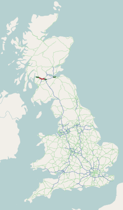
The M8 is the busiest motorway in Scotland. It connects the country's two largest cities, Glasgow and Edinburgh, and serves other large communities including Airdrie, Coatbridge, Greenock, Livingston and Paisley. The motorway is 60 miles (97 km) long. A major construction project to build the final section between Newhouse and Baillieston was completed on 30 April 2017. The motorway has one service station, Heart of Scotland Services, previously named Harthill due to its proximity to the village.

<span class="mw-page-title-main">Kingston Bridge, Glasgow</span> Bridge in Glasgow, Scotland

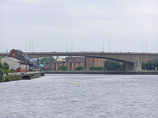
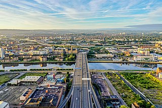
The Kingston Bridge is a balanced cantilever dual-span ten lane road bridge made of triple-cell segmented prestressed concrete box girders crossing the River Clyde in Glasgow, Scotland.

<span class="mw-page-title-main">Auchenshuggle</span> Human settlement in Scotland

Auchenshuggle is an area of Glasgow in Scotland, to the south of Tollcross.

<span class="mw-page-title-main">Transport in Glasgow</span> Overview of transport in Glasgow

The city of Glasgow, Scotland, has a transport system encompassing air, rail, road and an underground light metro line. Prior to 1962, the city was also served by trams. Commuters travelling into Glasgow from the neighbouring local authorities of North and South Lanarkshire, Renfrewshire, East Renfrewshire, and East and West Dunbartonshire have a major influence on travel patterns, with tens of thousands of residents commuting into the city each day. The most popular mode of transport in the city is the car, used by two-thirds of people for journeys around the city.

Carmyle is a suburb in the east end of Glasgow, Scotland, directly north of the River Clyde. It is in an isolated location separated from the main urban area of the city and has the characteristics of a semi-rural village. Administratively, Carmyle falls under the Shettleston ward of Glasgow City Council.

<span class="mw-page-title-main">Drumchapel</span> Human settlement in Scotland

Drumchapel, known locally as 'The Drum', is a district in the north-west of the city of Glasgow, Scotland. It borders Bearsden to the north-east and Drumry to the south-west, as well as Blairdardie, Garscadden, Knightswood and Yoker in Glasgow to the south; land to the north is undeveloped and includes the course of the Roman-era Antonine Wall. The name derives from the Gaelic meaning 'the ridge of the horse'.

<span class="mw-page-title-main">Laurieston, Glasgow</span> Human settlement in Scotland

Laurieston is a district in the Gorbals area of the Scottish city of Glasgow. It is situated south of the River Clyde. It derives its name from James Laurie who, along with his brother, developed a large part of the district in the early 19th century.

<span class="mw-page-title-main">Drumchapel railway station</span> Railway station in Glasgow, Scotland

Drumchapel railway station serves the Drumchapel, Blairdardie and Old Drumchapel areas of Glasgow, Scotland. The station is managed by ScotRail and is served by trains on the Argyle Line and North Clyde Line. It is situated between Westerton to the east and Drumry to the west, and is located 7 miles 20 chains (11.7 km) from Glasgow Queen Street, measured via Maryhill.
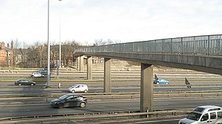
<span class="mw-page-title-main">Glasgow Inner Ring Road</span> Proposed road in Glasgow, Scotland, UK

The Glasgow Inner Ring Road was a proposed ring road encircling the city centre of Glasgow, Scotland. Construction of the roads began in 1965, and half of its circumference was completed by 1972, but no subsequent construction was made and the remaining plans were formally abandoned in 1980. After 30 years, a route following roughly the southern section of the proposals have also been created as the new M74.

<span class="mw-page-title-main">West Street subway station</span> Glasgow subway station

West Street subway station on the Glasgow Subway network serves the Tradeston and Kingston areas of Glasgow, Scotland.

<span class="mw-page-title-main">International Financial Services District</span> Multiple buildings containing office space in Glasgow, Scotland

The International Financial Services District (IFSD) is a public-private financial district in Glasgow, Scotland. Based at Scottish Enterprise, the venture aims to create an attractive inward investment location for leading international financial services companies and a re-location option for existing Glasgow-based companies, seeking to expand their operations.

The Polloc and Govan Railway was an early mineral railway near Glasgow in Scotland, constructed to bring coal and iron from William Dixon's collieries and ironworks to the River Clyde for onward transportation.

St Andrew's Cross, also known as Eglinton Toll, is a road junction in the south side of the city of Glasgow, Scotland. First constructed during the early 1800s, the junction formerly held several buildings including a power station and cinema, but have been removed for a variety of reasons. Since 1946 when the junction underwent a realignment, the two roads no longer intersect.

<span class="mw-page-title-main">Plantation, Glasgow</span> Human settlement in Scotland

Plantation is an area in the city of Glasgow, Scotland. It is situated south of the River Clyde and is part of the former Burgh of Govan.

<span class="mw-page-title-main">Auchenshuggle Bridge</span>

Auchenshuggle Bridge is a road bridge spanning the River Clyde in Glasgow, Scotland. The Auchenshuggle Bridge is the latest bridge to be built over the Clyde in the Auchenshuggle district of Glasgow, carrying the M74 motorway over the river and onto land which is part of Clydebridge Steelworks in Rutherglen, en route to the M8 junction near the heavily congested Kingston Bridge.

<span class="mw-page-title-main">Kingston, Glasgow</span>

Kingston is an area of Glasgow, Scotland, from which the Kingston Bridge takes its name. Together with Ibrox, it forms one of the 56 neighbourhoods of Glasgow defined by Glasgow City Council for operational purposes. The area was assigned to Ward 54 until 2007 when it was reclassified as part of the Govan ward.

<span class="mw-page-title-main">A724 road</span> Road in Scotland

The A724 road in Scotland runs within South Lanarkshire between Rutherglen and Hamilton. It follows an ancient route which is marked on William Roy's Lowland Map of Scotland (1755) with only minor deviations from its modern course.

<span class="mw-page-title-main">Buchanan Wharf</span> Building in Glasgow, Scotland

Buchanan Wharf is a complex of five mixed use buildings in the Tradeston area of Glasgow, Scotland. The complex comprises a total of five buildings, Clyde Place House, Tradescroft, Windmillcroft, Wellcroft and Grays Hill, with main usage being designated as office buildings. The complex houses the European headquarters of Barclays Bank, as well as the headquarters of the Student Loans Company, with other buildings in the complex ranging in usage from residential accommodation and a mix of local amenities.

References

  1. Clyde Place, Glasgow, Stallan-Brand
  2. Barclays opens new Glasgow campus that will be home to 5,000 employees, Glasgow Times, 12 October 2021
  3. Barclays complete riverside Glasgow campus, Urban Realm, 15 October 2021
  4. "Barclays unveils state-of-the-art campus in Glasgow". Barclays. 21 October 2021.
  5. Bus crash toll rises to five as girl dies, The Herald, 28 September 1994
  6. Anger at verdict over Guides death crash, The Independent, 22 March 1995
  7. I still blame myself for Cath's death | Tormented bus crash victim's mum tells court of agony, Daily Record, 21 October 1998, via thefreelibrary
  8. Drumchapel Girl Guides tragedy remembered 20 years on, Clydebank Post, 24 September 2014
  9. Judgement | Joseph Munro McKnight and Mrs Joan McKnight v. Clydeside Buses Limited and Glasgow City Council and Railtrack Plc and Mima Dunlop, Scottish Courts Service, 23 December 1998
  10. Police investigate after bus collides with bridge, The Herald, 25 March 2009, via PressReader
  11. Glasgow bridge strike rips bus roof off, BBC News, 20 August 2010
  12. Ten in hospital after bus roof cut off in Glasgow bridge crash, BBC News, 21 May 2023
  13. Man charged after bus crashed into Scots bridge leaving child and nine others in hospital, Steven Rae, Daily Record, 24 May 2023