Merchant City

Last updated

Merchant City
Merchant City, Glasgow.jpg
The Merchant City at night
Glasgow UK location map.svg
Red pog.svg
Merchant City
Location within Glasgow
OS grid reference NS595649
  Edinburgh 47 miles (76 km)
Council area
Lieutenancy area
  • Glasgow
Country Scotland
Sovereign state United Kingdom
Post town GLASGOW
Postcode district G1
Dialling code 0141
Police Scotland
Fire Scottish
Ambulance Scottish
UK Parliament
Scottish Parliament
List of places
UK
Scotland
Glasgow
55°51′24″N4°14′46″W / 55.8568°N 4.2462°W / 55.8568; -4.2462

The Merchant City, a new name introduced through urban renewal by the Scottish Development Agency and the city council in the 1980s is one part of the metropolitan central area of Glasgow. It commences at George Square and goes eastwards reaching Glasgow Cross, in the centre of Glasgow, Scotland. The eastern fringe of the Merchant City contains part of Glasgow's original medieval street plan, which stretches northwards towards neighbouring Townhead.

Contents

It contains offices, flats, retail shops, restaurants, and bars. [1] Part of the campus of the University of Strathclyde occupies the area. The Merchant City is home to several repurposed buildings including the City Halls & Old Fruitmarket, Merchant Square, and the Scottish Youth Theatre. It hosts many annual festivals.

The approximate definition of the Merchant City is the area defined by George Street to the north, High Street to the east, Trongate to the south, and Queen Street to the west.

History

The medieval Glasgow Cross continues at the junction of High Street, Trongate and Saltmarket. The town's tron, weighing scales, was placed next to the steeple of the town house in the 1550s. The Tron Steeple, as it became known, still stands at Glasgow Cross, one of the few remaining pre-Victorian buildings in Glasgow.

The area now known as 'Merchant City' was developed from the 1750s onwards. It also includes St Andrew's Square, adjacent to Glasgow Green. Residences and warehouses of the wealthy merchant "tobacco lords" were built in the area. The district west of the congested High Street became the ancient burgh's first planned New Town, with wide, straight streets, vistas, churches and squares, marking the start of aspirational residential movements westwards. That movement would continue with new names over two centuries, including, from 1800, the creation of a second New Town, being Blythswood upon Blythswood Hill, west of the new Buchanan Street, rising to Blythswood Square. [2] and beyond.

Tolbooth Steeple. Glasgow Tolbooth Steeple, Glasgow.jpg
Tolbooth Steeple.

As Glasgow expanded in the 19th century to become the second city of the United Kingdom and the British Empire, the old area became principally a centre of major warehouses, shipping companies, offices, distilleries and clothing manufacturers; while the markets continued in fruit, vegetables, cheese and fish. The more prosperous people moved out and set up home in the larger New Town of Blythswood.

After plans to construct the M8/M74 motorway ring road around the city centre were published in the 1960s much of the area fell into decline, with some of the buildings compulsorily purchased by the city council to allow for their demolition ahead pf the new road. The central food markets moved to modern premises further east of the city centre. At the same time the vast number of wholesale and manufacturing warehouses declined, largely because of the national ending of Retail Price Maintenance, and the continuing movement to out of town industrial estates. However the High Street motorway road was never built and in the 1980s the decision was taken by the city council and the Scottish Development Agency to revitalise the area and its historic buildings with public and private investment in its improvements and new uses.

The name 'Merchant City' was first coined by historian and writer Charles Oakley in the 1960s, ahead of this regeneration.

The Merchant City has been promoted and built up in recent years as a residential, shopping and leisure area, mirroring Covent Garden in the West End of London. To this end many new bars and restaurants have been established. This has been complemented with the building of prestigious new housing developments, often by restoring Victorian buildings. A later example being the GPO Building development in George Square.

Another important element of the area's transformation is high-end shopping, anchored by the Italian Centre designed by Page\Park Architects who are fond of including art in their architecture. Here the art is integral to the façades, but also features in the courtyard including a sculpture, 'Thinking of Bella' (1994) by Shona Kinloch.

The University of Strathclyde (which evolved from the Royal College of Science and Technology in the 1960s) has long had a presence in the area with several academic buildings along its northern fringe. It has owned the Ramshorn Cemetery and Church since 1983 and has used the latter as a theatre, with the most recent addition being the adjacent Technology and Innovation Centre (TIC) completed in 2014 and has regenerated much of the area between Ingram Street and George Street.

Festivals

Merchant is famous for their annual festivals. Merchant city festivals have a lot of different entertainments, including street arts, dance, live music, markets, fashion and design, comedy, family events, tours, heritage walks, talks, visual art, film, and children - families activities every year. [3] Merchant City Festival 2017 was held on 22–30 July 2017. [4] It included two great family events as Carnival Procession and Provand’s Lordship free Family Fun Zone. Among the highlights of the festival are carnival procession from Glasgow Cathedral , massed samba bands, a UNESCO music stage, the return of SURGE, the festival within a festival, a Street band “Encontro” and a celebration of street food. [5] During the festival, the city hosted Hip Replacement, a family Dance-along screening of Moana and Indiana Jones, and the hugely popular live sing-a-long Massaoke. [6]

Transport

The Merchant City area is primarily served by Queen Street and High Street railway stations on the suburban network. Buchanan Street Station on the Glasgow Subway is also a short walk from the area.

Related Research Articles

<span class="mw-page-title-main">Glasgow City Chambers</span> Municipal building in Glasgow, Scotland

The City Chambers or Municipal Buildings in Glasgow, Scotland, has functioned as the headquarters of Glasgow City Council since 1996, and of preceding forms of municipal government in the city since 1889. It is located on the eastern side of the city's George Square. It is a Category A listed building.

<span class="mw-page-title-main">Glasgow</span> Largest city in Scotland

Glasgow is the most populous city in Scotland and the third-most populous city in the United Kingdom, as well as being the 27th largest city by population in Europe. In 2022, it had an estimated population as a defined locality of 632,350 and anchored an urban settlement of 1,028,220. The city was made a county of itself in 1893, prior to which it had been in the historic county of Lanarkshire. The city now forms the Glasgow City Council area, one of the 32 council areas of Scotland, and is administered by Glasgow City Council.

<span class="mw-page-title-main">Glasgow City Council</span> Scottish unitary authority council in Glasgow, Scotland

Glasgow City Council is the local government authority for Glasgow City council area, Scotland. In its modern form it was created in 1996. Glasgow was formerly governed by a corporation, also known as the town council, from the granting of its first burgh charter in the 1170s until 1975. From 1975 until 1996 the city was governed by City of Glasgow District Council, a lower-tier authority within the Strathclyde region.

<span class="mw-page-title-main">George Square</span> Civic square in Glasgow, Scotland

George Square is the principal civic square in the city of Glasgow, Scotland. It is one of six squares in the city centre, the others being Cathedral Square, St Andrew's Square, St Enoch Square, Royal Exchange Square, and Blythswood Square on Blythswood Hill.

<span class="mw-page-title-main">Buchanan Street</span> Street in Glasgow, Scotland, UK

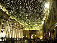
Buchanan Street is one of the main shopping thoroughfares in Glasgow, the largest city in Scotland. It forms the central stretch of Glasgow's famous shopping district with a generally more upmarket range of shops than the neighbouring streets: Argyle Street, and Sauchiehall Street.

<span class="mw-page-title-main">Townhead</span> Human settlement in Scotland

Townhead is a district within the city of Glasgow, Scotland. It is one of Glasgow's oldest areas, and contains many of its surviving medieval landmarks - most notably Glasgow Cathedral and the Provand's Lordship.

Garnethill is a predominantly residential area of the city of Glasgow, Scotland with a number of important public buildings.

<span class="mw-page-title-main">Transport in Glasgow</span> Overview of transport in Glasgow

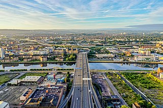
The city of Glasgow, Scotland, has a transport system encompassing air, rail, road and an underground light metro line. Prior to 1962, the city was also served by trams. Commuters travelling into Glasgow from the neighbouring local authorities of North and South Lanarkshire, Renfrewshire, East Renfrewshire, and East and West Dunbartonshire have a major influence on travel patterns, with tens of thousands of residents commuting into the city each day. The most popular mode of transport in the city is the car, used by two-thirds of people for journeys around the city.

<span class="mw-page-title-main">St George's Tron Church</span> Church in Glasgow, Scotland

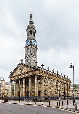
The St George's Tron Church, in Glasgow, Scotland, is a Church of Scotland church in the city centre, located in Nelson Mandela Place, previously known as St George's Place, fronting Buchanan Street at West George Street, along from Queen Street Station. It should not be confused with the 17th-century Tron Church, which lies to the south-west on Trongate and was redeveloped in the 1980s as the Tron Theatre. Located right on the busiest shopping street in Scotland, the building is a significant presence, and the oldest in the area. It stands as a terminating vista for West George Street.

<span class="mw-page-title-main">Blythswood Hill</span> Human settlement in Scotland

Blythswood Hill, crowned by Blythswood Square, is the wealthiest part of central Glasgow, Scotland. It extends from the west edge of Buchanan Street to Gordon Street and Bothwell Street, Charing Cross, Sauchiehall Street and Garnethill. Developed from 1800 onwards, its Georgian and Victorian architecture is a Conservation Area. It started as the "Magnificent New Town of Blythswood" becoming a part of the city-centre's business and social life.

<span class="mw-page-title-main">Trongate</span> Street in Glasgow

Trongate is one of the oldest streets in the city of Glasgow, Scotland. Trongate begins at Glasgow Cross, where the steeple of the old Glasgow Tolbooth is situated, being the original centre of medieval Glasgow, and goes westward changing its name to Argyle Street at Glassford Street. In modern times, it forms the notional southern boundary of the Merchant City area.

<span class="mw-page-title-main">Charing Cross, Glasgow</span> Road junction in Glasgow, Scotland, UK

Charing Cross is a major road junction in the Scottish city of Glasgow. It is situated north of the River Clyde at the intersection of Sauchiehall Street, St George's Road, Woodlands Road, North Street and Newton Street, as well as being at a major interchange of the M8 motorway.

<span class="mw-page-title-main">International Financial Services District</span> Multiple buildings containing office space in Glasgow, Scotland

The International Financial Services District (IFSD) is a public-private financial district in Glasgow, Scotland. Based at Scottish Enterprise, the venture aims to create an attractive inward investment location for leading international financial services companies and a re-location option for existing Glasgow-based companies, seeking to expand their operations.

<span class="mw-page-title-main">Glasgow Cross</span> Street in Glasgow City, Scotland, UK

Glasgow Cross is at the hub of the ancient royal burgh and now city of Glasgow, Scotland, close to its first crossing over the River Clyde. It marks the notional boundary between the city centre and the East End

Glasgow City Centre is the central business district of Glasgow, Scotland. Is bounded by Saltmarket, High Street and Castle Street to the east, The River Clyde to the south and the M8 motorway to its west and north. Glasgow City Centre is composed of the areas of Garnethill, Blythswood Hill and Merchant City as well as parts of Cowcaddens, Townhead, Anderston and Calton.

<span class="mw-page-title-main">St Andrew's Square, Glasgow</span>

St Andrew's Square is a public square in the city of Glasgow, Scotland and lies to the south east corner of Glasgow Cross, close to Glasgow Green. The square is noted for its immense 18th-century classical church, St Andrew's in the Square, from which the square takes its name. The church was completed in 1758, to the designs of architect Allan Dreghorn and master mason Mungo Naismith and is among the finest of its type anywhere in Britain. The interior has lavish 18th century rococo plasterwork. The building is Category A listed. It is one of six squares in the city centre.

<span class="mw-page-title-main">Blythswood Square</span>

Blythswood Square is the Georgian square on Blythswood Hill in the heart of the City of Glasgow, Scotland. The square is part of the 'Magnificent New Town of Blythswood' built in the 1800s on the rising empty ground west of a very new Buchanan Street. These open grounds were part of the vast Lands of Blythswood stretching to the River Kelvin acquired by the Douglas-Campbell family in the 17th century. The Blythswood district became a Conservation Area in 1970, because of its important architectural and historic buildings.

The politics of Glasgow, Scotland's largest city by population, are expressed in the deliberations and decisions of Glasgow City Council, in elections to the council, the Scottish Parliament and the UK Parliament.

<span class="mw-page-title-main">The Tron Church, Glasgow</span> Church in Glasgow, Scotland

The Tron Church, not to be confused with the similarly-named 'St George's Tron' church, is an evangelical presbyterian church which meets in three locations across Glasgow—in the city centre on Bath Street, in the Kelvingrove area of the West end of Glasgow, and on the Southside of Glasgow near Queen's Park.

<span class="mw-page-title-main">Sandyford, Glasgow</span> Area of Glasgow, Scotland

Sandyford is an area of Glasgow, Scotland. It is north of the River Clyde and forms part of the western periphery of the city centre. Formerly the name of a ward under Glasgow Town Council in the first part of the 20th century, it is within a continuous area of fairly dense urban development bordering several other neighbourhoods whose mutual boundaries have blurred over time, and is possibly less well known than all of the places which adjoin it, particularly Anderston and Finnieston.

References

  1. "Getting Ahead of Change: Glasgow City Centre Strategy and Action Plan 2014–19". Glasgow City Council. Retrieved 5 December 2021.
  2. Glasgow's Blythswood, by Graeme Smith, published in 2021
  3. "Merchant City Festival 2015 - SPT". SPT. 23 July 2015. Retrieved 26 August 2017.
  4. "Merchant City Festival". Merchant City Festival. Retrieved 26 August 2017.
  5. "Merchant City Festival returns for a week long celebration in Glasgow's cultural quarter". The List. 22 June 2017. Retrieved 26 August 2017.
  6. "Merchant City Festival 2017 Launched!". www.glasgowlife.org.uk. Retrieved 26 August 2017.