East Dunbartonshire is one of the 32 council areas of Scotland. It borders Glasgow City Council Area to the south, North Lanarkshire to the east, Stirling to the north, and West Dunbartonshire to the west. East Dunbartonshire contains many of the affluent areas north of Glasgow, including Bearsden, Milngavie, Milton of Campsie, Balmore, and Torrance, as well as many of Glasgow's commuter towns and villages. The council area covers parts of the historic counties of Dunbartonshire, Lanarkshire, and Stirlingshire.

Lanarkshire, also called the County of Lanark, is a historic county, lieutenancy area and registration county in the Central Lowlands of Scotland. The county is no longer used for local government purposes, but gives its name to the two modern council areas of North Lanarkshire and South Lanarkshire.
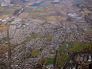
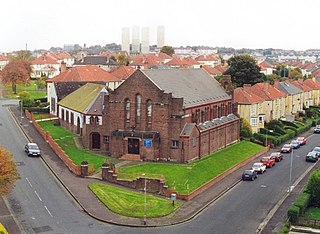
Bishopbriggs is a town in East Dunbartonshire, Scotland. It lies on the northern fringe of Greater Glasgow, approximately 4 miles (6 km) from the city centre. Historically in Lanarkshire, the area was once part of the historic parish of Cadder - originally lands granted by King William the Lion to the Bishop of Glasgow, Jocelin, in 1180. It was later part of the county of Lanarkshire, and then an independent burgh from 1964 to 1975. Today, Bishopbriggs' close geographic proximity to Glasgow now effectively makes it a suburb and commuter town of the city. The town's original Gaelic name Coille Dobhair reflects the name of the old parish of Cadder, but modern Gaelic usage uses Drochaid an Easbaig, a literal translation of Bishopbriggs. It was ranked the 2nd most desirable postcode in Scotland to live in following a study by the Centre for Economic and Business Research in 2015 and 2016.

Knightswood is a suburban district in Glasgow, containing three areas: Knightswood North or High Knightswood, Knightswood South or Low Knightswood, and Knightswood Park. It has a golf course and park, and good transport links with the rest of the city. Garscadden and Scotstounhill railway stations serve Low Knightswood while Westerton station serves High Knightswood. Knightswood is directly adjoined by the Anniesland, Blairdardie, Drumchapel, Garscadden, Jordanhill, Netherton, Scotstoun, Scotstounhill and Yoker areas of Glasgow, and by Bearsden in the north.
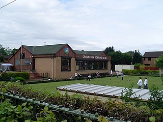
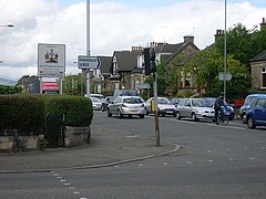
Crookston is a residential suburb on the southwestern edge of the city of Glasgow, Scotland.

Robroyston is a suburb of Glasgow, Scotland, located around 3 miles (5 km) north-east of the city centre.

Glasgow North East is a burgh constituency of the House of Commons of the Parliament of the United Kingdom. It was first contested at the 2005 general election. The current Member of Parliament (MP) is Anne McLaughlin of the SNP. McLaughlin herself previously represented the seat from 2015-17, when she lost the seat to Labour, but regained the seat at the 2019 general election and has represented the constituency ever since.

Springburn is an inner-city district in the north of the Scottish city of Glasgow, made up of generally working-class households.

Cowlairs is an area in the Scottish city of Glasgow, part of the wider Springburn district of the city. It is situated north of the River Clyde, between central Springburn to the east and Possilpark to the west.

Germiston is a neighbourhood in the city of Glasgow, Scotland, north of the River Clyde.

Milton is a district in the Scottish city of Glasgow, situated north of the River Clyde. The housing scheme is about 2+1⁄2 miles north of Glasgow City Centre and forms part of the northern edge of the city's urban area.

Royston/Roystonhill is a district in the city of Glasgow, Scotland. It was previously known as The Garngad and is still known as such by residents with a familial link to the area. It is notable for its large population of immigrants, mostly of Irish Catholic descent, with an annual St Patrick's Day Festival.

The A803 is a road in central Scotland. It runs from Glasgow to Champany Corner, three miles (4.8 km) due north-east of Linlithgow).
Auchinairn is a suburb within East Dunbartonshire, Scotland, and shares its southern boundary with the Robroyston and Balornock districts within the Glasgow City council area.

Cadder is a neighbourhood in the north of Glasgow, Scotland. Within the Canal ward under Glasgow City Council, historically more closely associated with the Lambhill and Maryhill districts, it is located 5 kilometres (3 mi) north of Glasgow city centre, sited on the route of the Forth and Clyde Canal. Occupying a footprint which is around 800 metres (870 yd) east to west but only 200 metres (220 yd) north to south on a fairly steep incline, the neighbourhood was built in the early 1950s and borders Glasgow Western Necropolis & Crematorium, Lambhill Cemetery and St. Kentigern's RC Cemetery, as well as Possil Marsh at its eastern side.
Parkhouse is a neighbourhood of Glasgow, Scotland. Within the G22 postcode area and the Canal ward of the Glasgow City Council administration, it is mainly residential in character having been constructed as a development primarily consisting of cottage flats in the early 1930s, prior to which it was open farmland.

Rosshall is an area in the south-west of Glasgow, Scotland, within the Cardonald ward of Glasgow City Council. It has a fairly isolated location, with the White Cart Water forming a border to the south and east, the Paisley Canal Line railway to the north, and open fields to the west that form a short green belt between Glasgow and the large town of Paisley – the nearest building 500 yards (460 m) to the west, Rosshall Mains Farm, falls under Paisley administration rather than Glasgow.

Canal is one of the 23 wards of Glasgow City Council. Since its creation in 2007 it has returned four council members, using the single transferable vote system. For the 2017 Glasgow City Council election, the boundaries were changed and the ward decreased in population, but continued to return four councillors.

Springburn/Robroyston is one of the 23 wards of Glasgow City Council. Created as Springburn, in 2007 and in 2012 it returned three council members, using the single transferable vote system. For the 2017 Glasgow City Council election, the boundaries were changed, the ward increased in size and population, was renamed Springburn/Robroyston and returned four members.

North East is one of the 23 wards of Glasgow City Council. On its creation in 2007 and in 2012 it returned four council members, using the single transferable vote system. For the 2017 Glasgow City Council election, the ward boundaries were redrawn with a smaller size and population, and it returned three members.