Rutherglen is a town in South Lanarkshire, Scotland, immediately south-east of the city of Glasgow, three miles from its centre and directly south of the River Clyde. Having previously existed as a separate Lanarkshire burgh, in 1975 Rutherglen lost its own local council and administratively became a component of the City of Glasgow District within the Strathclyde region. In 1996 the towns were reallocated to the South Lanarkshire council area.

An apartment, flat, or unit is a self-contained housing unit that occupies part of a building, generally on a single story. There are many names for these overall buildings. The housing tenure of apartments also varies considerably, from large-scale public housing, to owner occupancy within what is legally a condominium or leasehold, to tenants renting from a private landlord.

Pollok is a large housing estate on the south-western side of the city of Glasgow, Scotland. The estate was built either side of World War II to house families from the overcrowded inner city. Housing 30,000 at its peak, its population has since declined due to the replacement of substandard housing with lower-density accommodation. As of 2021, the population was recorded at 81,951 people.

Townhead is a district within the city of Glasgow, Scotland. It is one of Glasgow's oldest areas, and contains two of its major surviving medieval landmarks – Glasgow Cathedral and the Provand's Lordship.

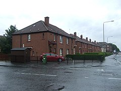
Parkhead is a district in the East End of Glasgow. Its name comes from a small weaving hamlet at the meeting place of the Great Eastern Road and Westmuir Street. Glasgow's Eastern Necropolis cemetery was laid out in the area in 1847 beside the Gallowgate.

Bridgeton is a district to the east of Glasgow city centre. Historically part of Lanarkshire, it is bounded by Glasgow Green to the west, Dalmarnock to the east and south, Calton to the north-west at Abercromby Street/London Road and Broad street to the north-east.

Whirlow is a suburb of the City of Sheffield in England, it lies 3.7 miles (6 km) south-west of the city centre. The suburb falls within the Dore and Totley ward of the City. It is one of the most affluent areas of Sheffield, with much high class housing and several notable small country houses within it. During the Victorian era it was home to some of Sheffield's most influential citizens. Whirlow straddles the A625, the main Sheffield to Hathersage road. The suburb covers the area from Parkhead in the north to Whirlow Bridge in the south and from Ecclesall Woods in the east to Broad Elms Lane in the west. Whirlow had a population of 1,663 in 2011.
Sciennes is a district of Edinburgh, Scotland, situated approximately 2 kilometres south of the city centre. It is a mainly residential district, although it is also well-known as the site of the former Royal Hospital for Sick Children. Most of its housing stock consists of terraces of four-storey Victorian tenements. The district is popular with students, thanks to its proximity to the University of Edinburgh. Its early history is linked to the presence in the area of the 16th-century Convent of St Catherine of Scienna, from which the district derives its name.
Carntyne is a suburban district in the Scottish city of Glasgow. It is situated north of the River Clyde, and in the east end of the city. it has formed the core of the East Centre ward under Glasgow City Council, which also includes the neighbouring Riddrie and Cranhill areas.

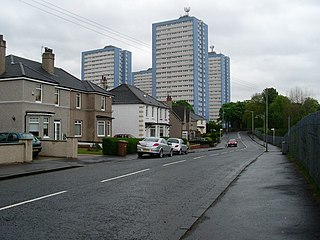
Easterhouse is a suburb of Glasgow, Scotland, 6 miles (10 km) east of the city centre on land gained from the county of Lanarkshire as part of an expansion of Glasgow before the Second World War. The area is on high ground north of the River Clyde and south of the River Kelvin and Campsie Fells.

Haghill is a residential neighbourhood in Glasgow, Scotland. It is situated in the east end of the city, north of the River Clyde. The housing includes tenements, former council houses and several more recently constructed homes. It is bordered by Alexandra Park to the north, Carntyne to the east, Dennistoun to the west and Parkhead to the south. Administratively, it falls within the Dennistoun ward of Glasgow City Council since a 2017 boundary re-assessment, having been in the East Centre ward for the decade prior.
Sandyhills is an area of the Scottish city of Glasgow. It is situated north of the River Clyde and has fallen within the Shettleston ward of Glasgow City Council since 2007.
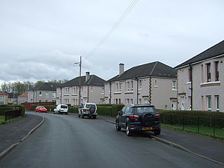
Merrylee is a neighbourhood in the Scottish city of Glasgow. It is situated south of the River Clyde within the Newlands/Auldburn ward surrounded by other residential areas: Newlands, Cathcart and Muirend, and is a housing scheme consisting of mostly ex-local authority homes constructed in the 1950s and 60s.
Braidfauld is a small area of Glasgow, Scotland which is in the East End of the city slightly north of the River Clyde and south of the Tollcross area. It was also the name of the 45th ward of Glasgow City Council, prior to the re-organisation into multi-member wards in 2007.
Lilybank is a neighbourhood in the east of Glasgow, Scotland. Neighbouring areas Newbank to the west, Braidfauld to the east and the eastern part of Parkhead to the north. The A74 London Road runs to the south, with the land on the opposite side between the road and the River Clyde not used for residential purposes: the Barrowfield football training ground owned by Celtic F.C., and the Dewar's whisky bottling plant and warehouses, the latter on the former Westthorn country estate.

Barrowfield is a neighbourhood of Glasgow, Scotland, close to Celtic Park, home of Celtic F.C., which lies immediately to the east. It is bounded by the A89 road (Gallowgate) to the north and the A74 to the south.
Parkhead Football Club was a Scottish football club from the Parkhead district of Glasgow who played in Scottish Junior Football Association competitions from their formation in 1880 until going out of business in 1963. Originally playing at The Sheddens on Old Shettleston Road, the club moved to Helenslea Park near current day Beattock/Sorby Streets in 1892 before development forced the club further out towards the Newbank/Lilybank area and into New Helenslea Park. In the early years of the Scottish Junior Cup, Parkhead appeared in nine finals and won the cup five times. The club supplied eight players who went on to become full Scotland internationals later in their careers and Andy Auld who played five times for the US national team.

Great Junction Street is a street in Leith, on the northern outskirts of Edinburgh, Scotland. It runs southeast to northwest following approximately the southwestmost line of the old town walls around Leith.

Newland is a suburb of Kingston upon Hull, East Riding of Yorkshire, England, in the north-west of the city, a former village on the Hull to Beverley turnpike.
Bridgeton Waverley Football Club was a Scottish football club based in Glasgow. Originally founded in 1904, they competed in the Junior grade from 1923 until folding in 1962.