
Glasgow City Council is the local government authority for the city of Glasgow, Scotland. In its modern form it was created in 1996. Glasgow was formerly governed by a corporation, also known as the town council, from the granting of its first burgh charter in the 1170s until 1975. From 1975 until 1996 the city was governed by City of Glasgow District Council, a lower-tier authority within the Strathclyde region.

Lanarkshire, also called the County of Lanark, is a historic county, lieutenancy area and registration county in the Central Lowlands of Scotland. The county is no longer used for local government purposes, but gives its name to the two modern council areas of North Lanarkshire and South Lanarkshire.

Baillieston is a suburb of Glasgow, Scotland. It is about 7 miles (11 km) east of the city centre.
Cranhill is an inner city district and housing scheme in the north east of Glasgow, Scotland. Cranhill was developed from public funding in the early 1950s and was originally, chiefly composed of four-storey tenement blocks surrounding a patch of grassland, which became Cranhill Park. Later development saw the building of three tower blocks, surrounded by rows of terraced maisonettes. In more recent years, a number of semi-detached and detached homes have been built. The area also hosts some shops, two primary schools and nurseries, a community centre and the Cranhill water tower.

Barlanark is a district in the Scottish city of Glasgow. It is situated east of Budhill, Shettleston and Springboig, north west of Baillieston, west of Springhill and Swinton and south of Easthall, Easterhouse and Wellhouse.

Easterhouse is a suburb of Glasgow, Scotland, 6 miles (10 km) east of the city centre on land gained from the county of Lanarkshire as part of an expansion of Glasgow before the Second World War. The area is on high ground north of the River Clyde and south of the River Kelvin and Campsie Fells.

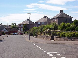
Garrowhill is a residential area within the wider Baillieston suburb of Glasgow, Scotland. It is situated approximately 7 miles (11 km) east of the city centre.
Swinton is an eastern suburb of the Scottish city of Glasgow, north of the areas of Baillieston and Garrowhill and east of Springhill. It is now concurrent with the 19th century Easterhouse village. The hamlet of Swinton began to emerge with the building of cotton hand loom weavers' cottages in the early 1790s. A housing development was constructed in the 1920s, with more in the 1970s, but most of the current neighbourhood was built from the 1990s onwards.

Springboig is a neighbourhood in the east end of the Scottish city of Glasgow, situated north of the River Clyde. Administratively, it has been within the city's East Centre ward since 2017, having previously been in the Baillieston ward.
Glasgow Baillieston was a burgh constituency of the House of Commons of the Parliament of the United Kingdom. It elected one Member of Parliament (MP) using the first-past-the-post voting system.

Glasgow Baillieston was a constituency of the Scottish Parliament (Holyrood). It elected one Member of the Scottish Parliament (MSP) by the plurality method of election. The seat was represented by Labour's Margaret Curran from the inception of the Scottish Parliament in 1999 until her retirement in 2011.

The Roman Catholic Diocese of Motherwell is an ecclesiastical diocese of the Catholic Church in Scotland.
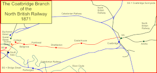
The Coatbridge Branch of the North British Railway was a railway built to connect the important coal and iron industrial districts of Coatbridge and Airdrie directly to Glasgow for the North British Railway.

Baillieston St Andrew's Church is a congregation of the Church of Scotland, a member of the Presbyterian Church. The church building is located on the corner of Bredisholm Road and Muirhead Road, Baillieston, Glasgow, Scotland. The church today serves the town of Baillieston.
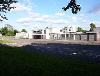
Bannerman High School is a state secondary school in the Baillieston suburb of Glasgow, Scotland. It is a non-denominational, co-educational, comprehensive school within the Glasgow City Council local education authority. The school teaches pupils from years S1 to S6. It has a capacity for 1400 pupils and has approximately 100 members of teaching staff. The current head teacher is Seonaidh Black.

Wellhouse is a residential neighbourhood in the East End of the Scottish city of Glasgow. Since 2007 it has been part of the Baillieston administrative ward within the Glasgow City Council area.

Broomhouse is a residential area in Glasgow, Scotland. It is about 6 miles (10 km) east of the city centre. Historically a small mining village and later the site of the Glasgow Zoo, in the early 21st century it grew substantially as an affluent commuter suburb.

Easthall is a residential neighbourhood in the East End of the Scottish city of Glasgow. Since 2007 it has been part of the Baillieston administrative ward within the Glasgow City Council area.

Baillieston is one of the 23 wards of Glasgow City Council. On its creation in 2007 and in 2012 it returned four council members, using the single transferable vote system. For the 2017 Glasgow City Council election, the boundaries were changed: the ward decreased in size and population, and returned three members.
Swinton Primary School and St Bridget's Primary School serves the local area, and from here pupils attend St Ambrose High School, Coatbridge, and Bannerman High School, Baillieston.

