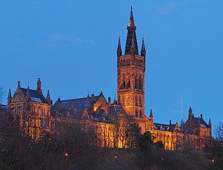
Glasgow is the most populous city in Scotland and the third-most populous city in the United Kingdom, as well as being the 27th largest city by population in Europe. In 2022, it had an estimated population as a defined locality of 632,350 and anchored an urban settlement of 1,028,220. The city was made a county of itself in 1893, prior to which it had been in the historic county of Lanarkshire. The city now forms the Glasgow City Council area, one of the 32 council areas of Scotland, and is administered by Glasgow City Council.
The Gorbals is an area in the city of Glasgow, Scotland, and former burgh, on the south bank of the River Clyde. By the late 19th century, it had become densely populated; rural migrants and immigrants were attracted by the new industries and employment opportunities of Glasgow. At its peak, during the 1930s, the wider Gorbals district had swollen in population to an estimated 90,000 residents, giving the area a very high population density of around 40,000/km2. Redevelopment after WWII has taken many turns, and the area's population is substantially smaller today. The Gorbals was also home to 16 high rise flat blocks; only six are standing as of 2023, and two of them are set to come down in the next couple of years.
Riddrie is a north-eastern district of Glasgow, Scotland. It lies on the A80 Cumbernauld Road.

Westhill is a suburban town in Aberdeenshire, Scotland, located 7 miles (11 km) west of the city of Aberdeen.

Anderston is an area of Glasgow, Scotland. It is on the north bank of the River Clyde and forms the south western edge of the city centre. Established as a village of handloom weavers in the early 18th century, Anderston was an independent burgh of barony from 1824 until it was incorporated into the City of Glasgow in 1846.

The Molendinar Burn is a burn in Glasgow, Scotland. It was the site of the settlement, Mellingdenor, that grew to become the kernel of Glasgow, and where St Mungo founded his church in the 6th century. It was later used to power the growing town's mills and the name became adapted because the word "molendinar" means "relating to a mill or millers", possibly because that is what the Welsh name Mellingdenor originally meant.

Arthur Thompson was a Scottish gangster who was active in Glasgow from the 1950s and took charge of organised crime in the city for over thirty years.

Glasgow North East is a burgh constituency of the House of Commons of the Parliament of the United Kingdom. It was first contested at the 2005 general election. The current Member of Parliament (MP) is Anne McLaughlin of the SNP. McLaughlin herself previously represented the seat from 2015-17, when she lost the seat to Labour, but regained the seat at the 2019 general election and has represented the constituency ever since.

Springburn is an inner-city district in the north of the Scottish city of Glasgow, made up of generally working-class households.

Calton, known locally as The Calton, is a district in Glasgow. It is situated north of the River Clyde, and just to the east of the city centre. Calton's most famous landmark is the Barras street market and the Barrowland Ballroom, one of Glasgow's principal musical venues.

Easterhouse is a suburb of Glasgow, Scotland, 6 miles (10 km) east of the city centre on land gained from the county of Lanarkshire as part of an expansion of Glasgow before the Second World War. The area is on high ground north of the River Clyde and south of the River Kelvin and Campsie Fells.

Germiston is a neighbourhood in the city of Glasgow, Scotland, north of the River Clyde.

Hogganfield is a district in the Scottish city of Glasgow, located to the north east of the city centre. Hogganfield is surrounded by the Glasgow districts of Blackhill, Craigend, Millerston, Provanmill, Riddrie, Robroyston, Ruchazie and Stepps. The M80, Stepps bypass, separates Hogganfield from Robroyston.
Sandyhills is an area of the Scottish city of Glasgow. It is situated north of the River Clyde and has fallen within the Shettleston ward of Glasgow City Council since 2007.

The A728 is a route number in Glasgow, Scotland applied to two connected roads.

Provan Gas Works is an industrial gas holding plant in the city of Glasgow, Scotland. The plant lies between the Blackhill, Blochairn, Germiston and Provanmill areas of the city, and was built by Glasgow Corporation between 1900 and 1904. It later became part of British Gas, and subsequently Transco and most recently Scotia Gas Networks who operate it today.
Blackhill is an area of north east Glasgow, Scotland. It is directly bordered by the M80 motorway to the west and the M8 motorway to the south. The neighbourhood falls within the North East ward under Glasgow City Council.
Gang-related organised crime in the United Kingdom is concentrated around the cities of London, Manchester and Liverpool and regionally across the West Midlands region, south coast and northern England, according to the Serious Organised Crime Agency. With regard to street gangs the cities identified as having the most serious gang problems, which also accounted for 65% of firearm homicides in England and Wales, were London, Birmingham, Manchester and Liverpool. Glasgow in Scotland also has a historical gang culture with the city having as many teenage gangs as London, which had six times the population, in 2008.
Stepps is a town in North Lanarkshire, Scotland, near the north-eastern outskirts of Glasgow. Its recently upgraded amenities include a new primary school, library and sports facilities. The town retains a historic heart around its church in Whitehill Avenue, whilst examples of Victorian and Edwardian housing can still be found. The travel connections by road and rail mean residents work in Glasgow, Edinburgh, Falkirk, Stirling and beyond. The town is located in close proximity to the new Seven Lochs Wetland Park, from which views to the Campsies and Loch Lomond can be enjoyed. Stepps has a population of around 6,730.

North East is one of the 23 wards of Glasgow City Council. On its creation in 2007 and in 2012 it returned four council members, using the single transferable vote system. For the 2017 Glasgow City Council election, the ward boundaries were redrawn with a smaller size and population, and it returned three members.

