Lilybank

Last updated

Lilybank
Glasgow UK location map.svg
Red pog.svg
Lilybank
Location within Glasgow
OS grid reference NS628636
Council area
Lieutenancy area
  • Glasgow
Country Scotland
Sovereign state United Kingdom
Post town GLASGOW
Postcode district G31 4 / G32 8
Dialling code 0141
Police Scotland
Fire Scottish
Ambulance Scottish
UK Parliament
Scottish Parliament
List of places
UK
Scotland
Glasgow
55°50′46″N4°11′34″W / 55.846035°N 4.192854°W / 55.846035; -4.192854 Coordinates: 55°50′46″N4°11′34″W / 55.846035°N 4.192854°W / 55.846035; -4.192854

Lilybank is a neighbourhood in the east of Glasgow, Scotland. Neighbouring areas Newbank to the west, Braidfauld to the east and the eastern part of Parkhead to the north. The A74 London Road runs to the south, with the land on the opposite side between the road and the River Clyde not used for residential purposes: the Barrowfield football training ground owned by Celtic F.C., and the Dewar's whisky bottling plant and warehouses, the latter on the former Westthorn country estate. [1] [2]

In a wider sense, many residents of Lilybank would consider themselves residents of Parkhead or Tollcross, but they were officially placed within the Braidfauld ward of Glasgow City Council from 1995 to 2007; [3] since then, the neighbourhood (west of Maukinfauld Road) has been in the Calton ward, while surrounding streets to the north and east fall under Shettleston ward.

History

The area was farmland until the 1930s, though small industries such as rope and brickworks [4] had also been established, as well as Wilson's Boilermakers. [5] [6] [7] [8] The Lilybank housing scheme, comprising "Rehousing" grade accommodation of low build quality (three-storey tile-roofed tenements of grey reconstituted stone, with back-courts for drying greens, normally containing six flats, all accessed from a doorless close) was opened in 1933 to accommodate tenants from the 19th-century slum clearance in Calton, Camlachie, Garngad and Parkhead. [9] [10] [11]

Most blocks were demolished in the 1990s and replaced by modern housing. At the time of the construction of the original housing, the small ground of Parkhead F.C., Helenslea Park, was located to the west between Lilybank and Newbank; [11] the club went defunct in the 1960s and the football pitch is no longer present, but it has been retained as an open public park; the only buildings on the site in the 2010s are named after Helenslea: a nursery school and community centre. [12] Parkhead Fire station was also located in Lilybank from 1952 until 2011. [13] [14]

In 1977, the neighbourhood was subject of a BBC Television documentary made by social activist Kay Carmichael, who lived on benefits in the community for some months while being recorded on hidden cameras to find out about the conditions for the city's poor; [15] [16] local residents were unimpressed at the unflattering way the area was portrayed. [17]

Related Research Articles

<span class="mw-page-title-main">Glasgow City Council</span> Scottish unitary authority council in Glasgow, Scotland, UK

Glasgow City Council is the local government authority for the city of Glasgow, Scotland. In its modern form it was created in 1996. Glasgow was formerly governed by a corporation, also known as the town council, from the granting of its first burgh charter in the 1170s until 1975. From 1975 until 1996 the city was governed by City of Glasgow District Council, a lower-tier authority within the Strathclyde region.

<span class="mw-page-title-main">Lanarkshire</span> Historic county in Scotland

Lanarkshire, also called the County of Lanark, is a historic county, lieutenancy area and registration county in the Central Lowlands of Scotland. The county is no longer used for local government purposes, but gives its name to the two modern council areas of North Lanarkshire and South Lanarkshire.

<span class="mw-page-title-main">Benburb F.C.</span> Association football club in Glasgow City, Scotland, UK

Benburb Football Club is a Scottish football club, based in Govan, Glasgow. Formed in 1885, the club is a member of the Scottish Junior Football Association and currently competes in the West of Scotland Football League. Benburb's colours are blue and white.

<span class="mw-page-title-main">Parkhead</span> Human settlement in Scotland

Parkhead is a district in the East End of Glasgow. Its name comes from a small weaving hamlet at the meeting place of the Great Eastern Road and Westmuir Street. Glasgow's Eastern Necropolis cemetery was laid out in the area in 1847 beside the Gallowgate.

<span class="mw-page-title-main">Bridgeton, Glasgow</span> Human settlement in Scotland

Bridgeton is a district to the east of Glasgow city centre. Historically part of Lanarkshire, it is bounded by Glasgow Green to the west, Dalmarnock to the east and south, Calton to the north-west at Abercromby Street/London Road and Broad street to the north-east.

<span class="mw-page-title-main">Tollcross, Glasgow</span> Human settlement in Scotland

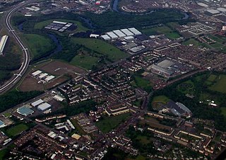
Tollcross is an area north of the River Clyde in Glasgow and has a popular park, opened in 1897, which is famed for its international rose trials. It lies approximately a mile east of the neighbouring suburb of Parkhead, and just north of Braidfauld and south of Shettleston.

<span class="mw-page-title-main">Queenslie</span> Human settlement in Scotland

Queenslie is a district in the Scottish city of Glasgow.

<span class="mw-page-title-main">Sandyhills</span> Human settlement in Scotland

Sandyhills is an area of the Scottish city of Glasgow. It is situated north of the River Clyde and has fallen within the Shettleston ward of Glasgow City Council since 2007.

<span class="mw-page-title-main">Springboig</span> Human settlement in Scotland

Springboig is a neighbourhood in the east end of the Scottish city of Glasgow, situated north of the River Clyde. Administratively, it has been within the city's East Centre ward since 2017, having previously been in the Baillieston ward.

<span class="mw-page-title-main">Shieldhall</span> Human settlement in Scotland

Shieldhall is a district in the Scottish city of Glasgow. It is situated directly south of the River Clyde and is part of the wider Govan area.

Braidfauld is a small area of Glasgow, Scotland which is in the East End of the city slightly north of the River Clyde and south of the Tollcross area. It was also the name of the 45th ward of Glasgow City Council, prior to the re-organisation into multi-member wards in 2007.

<span class="mw-page-title-main">Barrowfield</span> Neighbourhood of Glasgow, Scotland

Barrowfield is a neighbourhood of Glasgow, Scotland, close to Celtic Park, home of Celtic F.C., which lies immediately to the east. It is bounded by the A89 road (Gallowgate) to the north and the A74 to the south.

Parkhead Football Club was a Scottish football club from the Parkhead district of Glasgow who played in Scottish Junior Football Association competitions from their formation in 1880 until going out of business in 1963. Originally playing at The Sheddens on Old Shettleston Road, the club moved to Helenslea Park near current day Beattock/Sorby Streets in 1892 before development forced the club further out towards the Newbank/Lilybank area and into New Helenslea Park. In the early years of the Scottish Junior Cup, Parkhead appeared in nine finals and won the cup five times. The club supplied eight players who went on to become full Scotland internationals later in their careers and Andy Auld who played five times for the US national team.

The Switchback was a railway line in the East End of Glasgow, Scotland, constructed by the Caledonian Railway (CR). Connecting the lines at Rutherglen on the south side of the city with Robroyston on the north side, this route also served a number of industrial sidings and rail yards.

<span class="mw-page-title-main">Calton (ward)</span> Human settlement in Scotland

Calton is one of the 23 wards of Glasgow City Council. On its creation in 2007 and in 2012 it returned three council members, using the single transferable vote system. For the 2017 Glasgow City Council election, the seats increased to four due to the population having risen by 20% since it was first formed, although the boundaries did not change.

<span class="mw-page-title-main">Shettleston (ward)</span> Human settlement in Scotland

Shettleston is one of the 23 wards of Glasgow City Council. Since its creation in 2007 it has returned four council members, using the single transferable vote system; the boundaries have not changed since it was formed.

Bridgeton Waverley Football Club was a Scottish football club based in Glasgow. Originally founded in 1904, they competed in the Junior grade from 1923 until folding in 1962.

<span class="mw-page-title-main">Gallowgate, Glasgow</span> Human settlement in Scotland

Gallowgate is a neighbourhood of the city of Glasgow, Scotland. It takes its name from the major thoroughfare through the territory, which is part of the A89 road. Administratively, it is part of the Calton ward of the Glasgow City Council area.

<span class="mw-page-title-main">J. Pullar and Sons</span> Scottish dyeworks

J. Pullar and Sons Ltd. was a dyeworks based in Perth, Scotland. It was founded by John Pullar in 1824 in Perth's Little Pomarium district and pioneered the first synthetic dyes. Pullars of Perth signs eventually appeared outside 7,552 agents across Britain.

References

  1. Westthorn House (Glasgow University Library, Special Collections, Dougan Collection, 1870), The Glasgow Story
  2. Harvey's Dyke (Burrell Collection Photo Library, 1890s), The Glasgow Story
  3. Glasgow City Council area Electoral arrangements (3rd Review) Ward 45 Braidfauld, Local Government Boundary Commission for Scotland
  4. Westthorn Brickworks, London Road, Glasgow, Scottish Brick History
  5. SPW027255 SCOTLAND (1929). William Wilson and Co. Lilybank Boiler Works and Macfarlane, Lang and Co. Biscuit Factory, Clydeford Drive, Glasgow. An oblique aerial photograph taken facing east, Britain From Above
  6. spw027256 SCOTLAND (1929). William Wilson and Co. Lilybank Boiler Works, Tollcross, Glasgow. An oblique aerial photograph taken facing north, Britain From Above
  7. Wilson Boilermakers, Grace's Guide
  8. OS 25 inch Scotland, 1892-1905, Explore georeferenced maps (National Library of Scotland)
  9. SAW035573 SCOTLAND (1951). Beatson, Clarke and Co, Ltd., Braidfauld, Glasgow, Lanarkshire, Scotland, 1951. An oblique aerial photograph taken facing North, Britain From Above
  10. SAW051744 SCOTLAND (1953). Glasgow, general view, showing Macfarlane, Lang and Co. Victoria Biscuit Works, Clydeford Drive and Tolcross Road. An oblique aerial photograph taken facing north, Britain From Above
  11. 1 2 OS National Grid Maps, 1944-1967, Explore georeferenced maps (National Library of Scotland)
  12. Dance in Helenslea Community Hall is going 'on tour' around Glasgow, Evening Times, 17 April 2018
  13. V06 Parkhead, The History of Scottish Fire Brigades
  14. Parkhead Community Fire Station, Parkhead History
  15. Watching Ourselves: 60 Years of TV in Scotland: Lilybank - The Fourth World, BBC, 18 April 2012
  16. "Kay Carmichael". The Guardian. 12 January 2010.
  17. Decades before The Scheme, another Scots community suffered the TV treatment, Daily Record, 27 June 2010