
Glasgow City Council is the local government authority for Glasgow City council area, Scotland. In its modern form it was created in 1996. Glasgow was formerly governed by a corporation, also known as the town council, from the granting of its first burgh charter in the 1170s until 1975. From 1975 until 1996 the city was governed by City of Glasgow District Council, a lower-tier authority within the Strathclyde region.

Cathcart is an area of Glasgow between Battlefield, Mount Florida, King's Park, Muirend and Newlands. The White Cart Water flows through Cathcart, downstream from Linn Park. In 2014, it was rated one of the most attractive postcode areas to live in Scotland.
Giffnock is a town and the administrative centre of East Renfrewshire in the Central Lowlands of Scotland.

Pollokshields is an area in the Southside of Glasgow, Scotland. Its modern boundaries are largely man-made, being formed by the M77 motorway to the west and northwest with the open land of Pollok Country Park and the Dumbreck neighbourhood beyond, by the Inverclyde Line railway and other branches which separate its territory from the largely industrial areas of Kinning Park, Kingston and Port Eglinton, and by the Glasgow South Western Line running from the east to south, bordering Govanhill, Strathbungo, Crossmyloof and Shawlands residential areas. There is also a suburban railway running through the area.

Shawlands is a Southside suburb of Glasgow, Scotland, located two miles south of the River Clyde. The area, considered the "Heart of the Southside", is known for its independent restaurants and cafés, art scene, public parks, period terraces, and red and blond sandstone tenements. Shawlands was named one of the best places to live in Scotland in 2022 and 2023 by The Sunday Times, and one of the world's coolest neighbourhoods by Time Out Magazine with judges describing it as "the city's best area to live and socialise”. It is located between Pollok Country Park – the home of the Burrell Collection and Pollok House – and the acclaimed Victorian park Queen's Park.

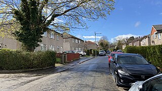
Netherlee is a suburban residential area in East Renfrewshire, Scotland. It is situated on the west bank of the White Cart Water about 4 miles (6.5 km) south of Glasgow city centre. Part of the Greater Glasgow conurbation, it is mostly contiguous with the city, and is just beyond the boundary of its local authority area. It is a separate census locality from Glasgow, like other areas such as neighbouring Giffnock and Clarkston. Netherlee is directly contiguous with Stamperland. It is also in a council ward with Clarkston and its neighbour Busby. As of 2012, Netherlee has a population of 4,550.
Mount Florida is an area in the south-east of the city of Glasgow, Scotland.
Croftfoot is a residential area on the southeastern side of the Scottish city of Glasgow. It is bordered by Castlemilk to the south and King's Park to the west within Glasgow, and by the Rutherglen areas of Spittal to the east and Bankhead to the north. Historically within the civil parish of Cathcart in Renfrewshire, it is within the Linn ward of Glasgow City Council.

Thornliebank is a suburban area in East Renfrewshire, in the west central Lowlands of Scotland. Part of the Greater Glasgow conurbation, it is located on the Auldhouse Burn about six miles south of Glasgow city centre, and just outside the city's administrative boundaries. The neighbouring East Renfrewshire town of Giffnock lies directly to the east, with Rouken Glen Park to the south.
Sandyhills is an area of the Scottish city of Glasgow. It is situated north of the River Clyde and has fallen within the Shettleston ward of Glasgow City Council since 2007.
Cowglen is a district in the Scottish city of Glasgow, within the Newlands/Auldburn ward of the city but geographically closer to the large suburb of Pollok. It is situated south of the River Clyde. Much of its territory is open land occupied by a golf course, and it also adjoins Pollok Country Park.

Govanhill is an area of Glasgow, Scotland, situated south of the River Clyde between Pollokshields, the Gorbals, Strathbungo, Crosshill, Polmadie and Queen's Park. Historically part of Renfrewshire, Govanhill had the status of a police burgh between 1877 and 1891 before becoming part of the City of Glasgow. Since 2007, it has fallen under the Southside Central ward of Glasgow City Council. A previous smaller ward named Govanhill had boundaries of Dixon Avenue and Dixon Road to the south, Victoria Road to the west, Butterbiggins Road to the north and Aikenhead Road to the east.

Newlands is an affluent suburb in the south side of Glasgow, Scotland. The area is mainly residential in character. Shawlands and Langside lie to the north of the district, Pollokshaws and Auldhouse to the west, Giffnock to the south, and Merrylee and Cathcart to the east.

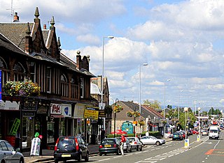
Muirend is an area on the South side of Glasgow, Scotland. It is situated about 4 miles (6.5 km) south of Glasgow city centre. Muirend became extensively urbanised in the 20th century, developing into a commuter suburb. In a 2014 Royal Mail survey, the G44 postcode – which includes Muirend – was rated as the most desirable area of Scotland to live in. Neighbouring areas include Cathcart, Merrylee and Newlands in Glasgow, and Netherlee and Giffnock in East Renfrewshire. Some buildings that are locally associated with Muirend, including the main row of shops, as well as Hazelden Park and Muirend Pavilion, are located in East Renfrewshire. Notable residents include Sam McAulay amongst others.

Langside is a district in the Scottish city of Glasgow. It is situated south of the River Clyde, and lies east of Shawlands, south of Queens Park, west of Cathcart and north of Newlands. The district is residential and primarily middle-class, and has become an increasingly fashionable address in recent years. Housing stock is mainly of the Victorian tenement type, along with some townhouses of the same period.

Glasgow Cathcart is a constituency of the Scottish Parliament (Holyrood), being one of eight constituencies within the Glasgow City council area. It elects one Member of the Scottish Parliament (MSP) by the plurality method of election. It is also one of nine constituencies in the Glasgow electoral region, which elects seven additional members, in addition to nine constituency MSPs, to produce a form of proportional representation for the region as a whole.

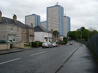
King's Park is a district in the city of Glasgow, Scotland. It is situated south of the River Clyde and borders the Glasgow areas of Croftfoot, Cathcart, Simshill, Mount Florida and Toryglen and the neighbourhood of Bankhead in the adjoining town of Rutherglen.
Newlands/Auldburn is one of the 23 wards of Glasgow City Council. Situated south of the city and the River Clyde, it is represented by 3 members as of May 2022, one each from the Scottish National Party, Scottish Labour, and Scottish Green Party.

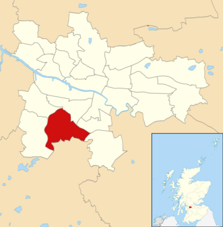
Eastwood is a residential neighbourhood in the city of Glasgow, Scotland. It is situated south of the River Clyde, and is part of the Newlands/Auldburn ward under Glasgow City Council.
