Related Research Articles

Glasgow City Council is the local government authority for Glasgow City council area, Scotland. In its modern form it was created in 1996. Glasgow was formerly governed by a corporation, also known as the town council, from the granting of its first burgh charter in the 1170s until 1975. From 1975 until 1996 the city was governed by City of Glasgow District Council, a lower-tier authority within the Strathclyde region.

Lanarkshire, also called the County of Lanark, is a historic county, lieutenancy area and registration county in the Central Lowlands and Southern Uplands of Scotland. The county is no longer used for local government purposes, but gives its name to the two modern council areas of North Lanarkshire and South Lanarkshire.

Nitshill is a district on the south side of Glasgow. It is bordered by South Nitshill to the south, Darnley to the east, Crookston and Roughmussel to the north-west, Hurlet to the west and Househillwood and Priesthill to the north, with the Pollok district and the Silverburn Centre beyond. An area of open ground to the south-west of Nitshill forms the boundary between Glasgow and the town of Barrhead in East Renfrewshire.

Maryhill is an area in the north-west of Glasgow in Scotland. A former independent burgh and the heart of an eponymous local authority ward, its territory is bisected by Maryhill Road, part of the A81 road which runs for a distance of roughly three miles between Glasgow city centre and the suburban town of Bearsden.

Pollok is a large housing estate on the south-western side of the city of Glasgow, Scotland. The estate was built either side of World War II to house families from the overcrowded inner city. Housing 30,000 at its peak, its population has since declined due to the replacement of substandard housing with lower-density accommodation. As of 2021, the population was recorded at 81,951 people.

North Kelvinside is a residential district of the Scottish city of Glasgow.
Glasgow Maryhill was a parliamentary constituency represented in the House of Commons of the Parliament of the United Kingdom from 1918 to 2005 when it was subsumed into the new Glasgow North and Glasgow North East constituencies. It elected one Member of Parliament (MP) using the first-past-the-post voting system.

The Maryhill Line is a suburban railway line linking central Glasgow and Anniesland via Maryhill in Scotland. It is part of the Strathclyde Partnership for Transport network. The line between Glasgow and Maryhill forms a part of the West Highland Line and was reopened to stopping passenger services in 1993. The line was reopened by British Rail and Strathclyde Passenger Transport Executive. Local services over the route had previously ended in the early 1960s, though it remained open thereafter for Fort William/Mallaig & Oban trains and freight traffic. In 2005 it was extended to Anniesland via a new station at Kelvindale in the north west of the city.

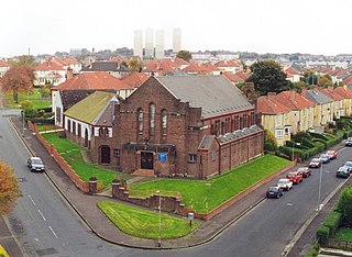
Milton is a district in the Scottish city of Glasgow, situated north of the River Clyde. The housing scheme is about 2+1⁄2 miles north of Glasgow City Centre and forms part of the northern edge of the city's urban area.

Ruchill is a district in the city of Glasgow, Scotland. It lies within the Canal Ward of north Glasgow in the Ruchill Community Council area between the Maryhill and Possilpark and North Kelvinside areas of the city.

South Nitshill is a neighbourhood in the Scottish city of Glasgow. It is situated south of the River Clyde, in the south-west of the conurbation and within the Greater Pollok ward of the local authority area. All streets in the area have names beginning with 'W'.

Langside is a district in the Scottish city of Glasgow. It is situated south of the River Clyde, and lies east of Shawlands, south of Queens Park, west of Cathcart and north of Newlands. The district is residential and primarily middle-class, and has become an increasingly fashionable address in recent years. Housing stock is mainly of the Victorian tenement type, along with some townhouses of the same period.

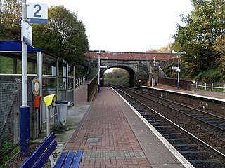
Ashfield railway station is a railway station serving the Milton and Parkhouse areas of Glasgow, Scotland. It is located on the Maryhill Line, 2+1⁄2 miles (4 km) north of Glasgow Queen Street, a short distance west of Cowlairs North Junction. It has two side platforms. Services are provided by ScotRail on behalf of Strathclyde Partnership for Transport (SPT).
The Lanarkshire and Dumbartonshire Railway was a railway company in Scotland. It was promoted independently but supported by the Caledonian Railway, and it was designed to connect Balloch and Dumbarton with central Glasgow, linking in heavy industry on the north bank of the River Clyde. From Dumbarton to Balloch the line would have closely duplicated an existing railway, and negotiation led to the latter being made jointly operated, and the L&DR terminated immediately east of Dumbarton, trains continuing on the joint section.
The Glasgow, Dumbarton and Helensburgh Railway was independently sponsored to build along the north of the River Clyde. It opened in 1858, joining with an earlier local line serving Balloch. Both were taken over by the powerful North British Railway in 1865, and for some time the line was the main route in the area. As industry developed other lines were opened to serve it, and the line formed the core of a network in the area.
Gilshochill is located to the north west of Maryhill in the city of Glasgow, Scotland. Immediately north of Maryhill basin and Maryhill locks, it is the district where the Bowling and Port Dundas branches of the Forth and Clyde Canal meet at Stockingfield Junction. Situated on a hill overlooking Glasgow, its highest point sits at an elevation of about 150 metres above sea level. Gilshochill is spread over the area around Sandbank Street, bordering the areas of Cadder and Summerston. It falls under the G20 area postal code. It is served by Gilshochill railway station. A new footbridge connecting the area with Ruchill and providing a better link to Maryhill was installed across the canal at Stockingfield Junction in 2022.

Maryhill is one of the 23 wards of Glasgow City Council. It was created in 2007 as Maryhill/Kelvin, and in that election it returned four council members, using the single transferable vote system. The same boundaries were used in 2012. For the 2017 Glasgow City Council election, the boundaries were changed, the ward substantially decreased in territory and population, was renamed Maryhill and returned three members.
Parkhouse is a neighbourhood of Glasgow, Scotland. Within the G22 postcode area and the Canal ward of the Glasgow City Council administration, it is mainly residential in character having been constructed as a development primarily consisting of cottage flats in the early 1930s, prior to which it was open farmland.

Parkhouse is a residential neighbourhood of Glasgow, Scotland close to the border with East Renfrewshire. It is located on the south-western edge of the city, close to the towns of Barrhead and Newton Mearns in East Renfrewshire. Within the G53 postcode area and the Greater Pollok ward of the Glasgow City Council administration, the eastern cluster of private housing was constructed in the 1980s and the western part in the 2010s, prior to which it was open farmland annexed to Glasgow in 1938.

Canal is one of the 23 wards of Glasgow City Council. Since its creation in 2007 it has returned four council members, using the single transferable vote system. For the 2017 Glasgow City Council election, the boundaries were changed and the ward decreased in population, but continued to return four councillors.
References
- ↑ [Population] For further info, visit the selected district to view Intermediate Data Zones used http://statistics.gov.scot/data/population-estimates-current-geographic-boundaries
- ↑ [Area] For further info, visit the selected district to view Intermediate Data Zones used http://statistics.gov.scot/data/land-area-2011-data-zone-based