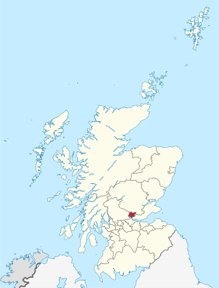
Clackmannanshire, or the County of Clackmannan, is a historic county, council area, registration county and lieutenancy area in Scotland, bordering the council areas of Stirling, Fife, and Perth and Kinross. In terms of historic counties it borders Perthshire, Stirlingshire and Fife.

Alloa is a town in Clackmannanshire in the Central Lowlands of Scotland. It is on the north bank of the Forth at the spot where some say it ceases to be the River Forth and becomes the Firth of Forth. Alloa is south of the Ochil Hills, 5.5 miles (8.9 km) east of Stirling and 7.9 miles (12.7 km) north of Falkirk; by water Alloa is 25 miles (40 km) from Granton.
Tillicoultry is a town in Clackmannanshire, Scotland. Tillicoultry is usually referred to as Tilly by the locals.

Dollar is a small town with a population of 2,800 people in Clackmannanshire, Scotland. It is 12 miles east of Stirling.

Menstrie is a village in the county of Clackmannanshire in Scotland. It is about five miles east-northeast of Stirling and is one of a string of towns that, because of their location at the foothill base of the Ochil Hills, are collectively referred to as the Hillfoots Villages or simply The Hillfoots.

Alva is a small town in Clackmannanshire, set in the Central Lowlands of Scotland. It is one of a number of towns situated immediately to the south of the Ochil Hills, collectively referred to as the Hillfoots Villages or simply The Hillfoots. It is located between Tillicoultry and Menstrie. Alva had a resident population of 5,181 at the 2001 census but this has since been revised to 4,600 in 2016. It boasts many features such as a park with an event hall and a newly opened outdoor gym, and is the home of Alva Academy.
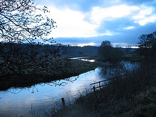
The River Devon is a tributary of the River Forth in Clackmannanshire and Perth & Kinross, Scotland.

Tullibody is a town set in the Central Lowlands of Scotland. It lies north of the River Forth near to the foot of the Ochil Hills within the Forth Valley. The town is 1.8 miles (2.9 km) south-west of Alva, 1.8 miles (2.9 km) north-west of Alloa and 4.0 miles (6.4 km) east-northeast of Stirling. The town is part of the Clackmannanshire council area.

The Stirling and Dunfermline Railway was a railway in Scotland connecting Stirling and Dunfermline. It was planned by the Edinburgh and Glasgow Railway to get access to the mineral deposits on the line of route, but also as a tactical measure to keep the rival Caledonian Railway out of Fife.
The FK postcode area, also known as the Falkirk postcode area, is a group of 21 postcode districts in central Scotland, within 18 post towns. These cover most of the Falkirk council area, most of the Stirling council area and Clackmannanshire, plus small parts of Fife, Perth and Kinross, and Argyll and Bute.

Sauchie is a town in the Central Lowlands of Scotland. It lies north of the River Forth and south of the Ochil Hills, within the council area of Clackmannanshire. Sauchie has a population of around 6000 and is located one mile northeast of Alloa and two miles east-southeast of Tullibody.
The Alloa Waggonway, also known as the Alloa Railway was an early tramway. It was 2+1⁄2 miles (4 km) miles long and connected coal pits above Alloa with the harbour and a bottle manufacturer at Alloa in Clackmannanshire, Scotland. The track was wooden with an iron running surface, and wagons were drawn by horses.
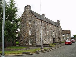
Menstrie Castle is a three-storey manor house in the town of Menstrie, Clackmannanshire, near Stirling, central Scotland. From the early 17th century, it was home to Sir William Alexander, 1st Earl of Stirling, who was instrumental in founding the colony of Nova Scotia. It was later owned by the Holburn or Holborne family, who were created Baronets of Menstrie in 1706. The castle was restored in the 20th century, won a Civic Trust award, and now incorporates holiday accommodation, private flats, and a museum and cafe run by the National Trust for Scotland.

Sauchie Tower, also known as Devon Tower, is a 15th-century tower house in Clackmannanshire, Scotland. The tower is located by the village of Fishcross, 1 kilometre (0.62 mi) north of Sauchie and 2.5 kilometres (1.6 mi) north of Alloa, close to the River Devon. It is protected as a Scheduled Ancient Monument.
Strathdevon is the strath of the River Devon in Clackmannanshire, Scotland. Strathdevon is associated with the parish of Muckhart and was up until 1971 the southernmost tip of Perthshire.

Cambus is a village near Alloa, Clackmannanshire. It is located to the south of Tullibody, to the northwest of Alloa, and about 4 miles east of Stirling, across the river. It lies on the River Devon, near its confluence with the River Forth.
John Melvin (1855–1905) was a Scottish architect in central Scotland specialising in Arts & Crafts architecture.


