Alexandria is a town in West Dunbartonshire, Scotland. The town is on the River Leven, three miles north of Dumbarton and 15 mi (24 km) north-west of Glasgow.
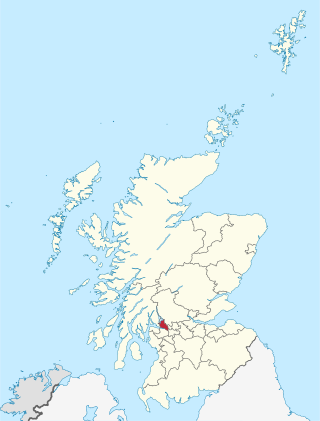
West Dunbartonshire is one of the 32 local government council areas of Scotland. The area lies to the north-west of the Glasgow City council area and contains many of Glasgow's commuter towns and villages. West Dunbartonshire also borders Argyll and Bute, East Dunbartonshire, Renfrewshire and Stirling.
The Vale of Leven is an area of West Dunbartonshire, Scotland, in the valley of the River Leven. Historically, it was part of The Lennox, the name of which derives from the Gaelic term Leamhnach, meaning field of the Leven. Leamnha is thought to mean elm-water.

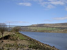
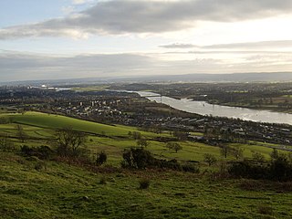
Dumbarton is a town in West Dunbartonshire, Scotland, on the north bank of the River Clyde where the River Leven flows into the Clyde estuary. In 2006, it had an estimated population of 19,990.
Clydebank is a town in West Dunbartonshire, Scotland. Situated on the north bank of the River Clyde, it borders the village of Old Kilpatrick to the west, and the Yoker and Drumchapel areas of the adjacent City of Glasgow immediately to the east. Depending on the definition of the town's boundaries, the suburban areas of Duntocher, Faifley and Hardgate either surround Clydebank to the north, or are its northern outskirts, with the Kilpatrick Hills beyond.

The North Clyde Line is a suburban railway in West Central Scotland. The route is operated by ScotRail. As a result of the incorporation of the Airdrie–Bathgate rail link and the Edinburgh–Bathgate line, this route has become the fourth rail link between Glasgow and Edinburgh.

Balloch is a village in West Dunbartonshire, Scotland, at the foot of Loch Lomond.

Milton is a village in West Dunbartonshire, Scotland. It lies about one mile east of Dumbarton, on the A82 Glasgow-Loch Lomond road and below the Overtoun Bridge.

Dalmuir is an area nine miles northwest of Glasgow, Scotland, on the western side of Clydebank, and part of West Dunbartonshire Council Area. The name is a lowland Scots derivation of the Gaelic meaning Big Field. The area was originally two separate villages with Dalmuir Shore joining with Clydebank in 1886 and Dalmuir Village in 1906, during a period of rapid industrialization and expansion. Dalmuir is bounded by the village of Old Kilpatrick to the west, the Mountblow and Parkhall housing schemes to the north, and the Clydebank town centre area to the east. To the south is the River Clyde.
Dumbarton Central railway station serves the town of Dumbarton in West Dunbartonshire, Scotland. This station is on the West Highland Line and the North Clyde Line, 15+3⁄4 miles (25.3 km) northwest of Glasgow Queen Street.

Drumry railway station serves the Drumry and Linnvale area of Clydebank, West Dunbartonshire, Scotland. The railway station is managed by ScotRail and is served by trains on the Argyle Line and North Clyde Line.

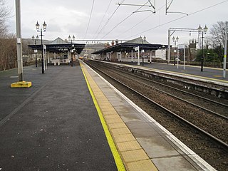
Alexandria railway station serves the town of Alexandria, Scotland. The station is managed by ScotRail and is served by their trains on the North Clyde Line. It is sited 19 miles 20 chains (31.0 km) northwest of Glasgow Queen Street, measured via Singer and Maryhill, and is situated between Renton and Balloch.
The Lanarkshire and Dumbartonshire Railway was a railway company in Scotland. It was promoted independently but supported by the Caledonian Railway, and it was designed to connect Balloch and Dumbarton with central Glasgow, linking in heavy industry on the north bank of the River Clyde. From Dumbarton to Balloch the line would have closely duplicated an existing railway, and negotiation led to the latter being made jointly operated, and the L&DR terminated immediately east of Dumbarton, trains continuing on the joint section.
The Caledonian and Dumbartonshire Junction Railway (C&DJR) was a Scottish railway opened in 1850 between Bowling and Balloch via Dumbarton. The company had intended to build to Glasgow but it could not raise the money.
The Glasgow, Dumbarton and Helensburgh Railway was independently sponsored to build along the north of the River Clyde. It opened in 1858, joining with an earlier local line serving Balloch. Both were taken over by the powerful North British Railway in 1865, and for some time the line was the main route in the area. As industry developed other lines were opened to serve it, and the line formed the core of a network in the area.

The Kilpatrick Hills are a range of hills in central Scotland, stretching from Dumbarton in the west to Strathblane in the east.
This page is based on this
Wikipedia article Text is available under the
CC BY-SA 4.0 license; additional terms may apply.
Images, videos and audio are available under their respective licenses.