Milton Island

Last updated

Milton Island
River Leven joins the River Clyde - geograph.org.uk - 674060.jpg
River Clyde near Milton Island
Location
West Dunbartonshire UK relief location map.jpg
Red pog.svg
Milton Island
Relief maps of Milton Island
Renfrewshire UK relief location map.jpg
Red pog.svg
Milton Island
Milton Island (Renfrewshire)
Scotland relief location map.jpg
Red pog.svg
Milton Island
Milton Island (Scotland)
OS grid reference NS 42651 73794
Coordinates 55°55′53″N4°31′13″W / 55.931381°N 4.5202637°W / 55.931381; -4.5202637
Physical geography
Island groupIslands of the River Clyde
Area1.852 acres (7,495 m2) in 1905
Highest elevation<3 metres (9.8 ft)
Administration
Sovereign state United Kingdom
Country Scotland
Council area Dunbartonshire
Demographics
Population0
Lymphad3.svg

Milton Island or Green Inch [1] was an island in the Clyde's estuarine waters close to the old ford across the river at Dumbuck near Dumbarton. [2] [3] The island was once part of the tidal ford supposedly built by the Romans. Industrial activity has changed the river currents and the island has become substantially reduced in size and split into islets.

Contents

Islands in the River Clyde

Islands of the River Clyde, rather than sand or mud banks only exposed at low water, once included in order, working upstream towards Glasgow :- Bodinbo, Newshot, Ron, Sand Inch, King's Inch, Buck Inch, White Inch and Water Inch. Colin's Isle was located in the Cart Water near its confluence with the Clyde.

The name 'Inch' is Scots deriving from the Gaelic 'Innis', an island. [4]

Milton Island

view from Milton Island Milton Island - geograph.org.uk - 1805787.jpg
view from Milton Island
Bollards on the River Clyde Bollards on the River Clyde (geograph 5682584).jpg
Bollards on the River Clyde
The Dumbuck Perch. Dumbuck Perch - geograph.org.uk - 932278.jpg
The Dumbuck Perch.

Lying between Dumbarton and Dunglass Castle below Dumbuck Hill the island is recorded as 'Green Inch' on William Roy's map of 1747–55. [5] By 1821 the island is recorded as Millton Island, lying just off shore from the village of that name. [6]

The Ordnance Survey Name Book of 1860 records Milton Island as "An Island in the foreshore of the Clyde at Milton from which it is named. It is never covered at High Water above the H.W.M. [High Water Mark] shewn.". [7]

The old Esso terminal lying just upstream of Milton Island has had a significant effect on the patterns of erosion and deposition to the extent that the island is no longer a single island but of 2018 exists as three small grassy islets that lie within the larger boundary of the old island. [8]

The Dumbuck Perch (NS 4132 7385) stands nearby as a slightly elevated area strewn with stones.

Dumbuck Ford

Suggested remnants of the paved Roman ford looking towards Dumbuck Hill Supposed remains of a Roman causeway on the River Clyde (geograph 1941900).jpg
Suggested remnants of the paved Roman ford looking towards Dumbuck Hill
Suggested remnants of the Roman paved ford Supposed remains of a Roman causeway (geograph 1941946).jpg
Suggested remnants of the Roman paved ford
The Lang Dyke The Lang Dyke, River Clyde (geograph 1940839).jpg
The Lang Dyke
The Lang Dyke (Erskine Bridge in background) The Lang Dyke (geograph 1940903).jpg
The Lang Dyke (Erskine Bridge in background)

At low tide the River Clyde at Dumbuck could be forded and in Roman times to facilitate the crossing a 7 m (23 ft) wide causeway was supposedly constructed running northwards from Longhaugh, curving through the river-dyke and passing as a low mound towards the beach. The causeway continued as with a cobbled surface atop a gravelly mound continuing towards the Long Dyke and the Longhaugh Light. [9] It then ran across Milton Island and went on to run through a field gate and on as a low mound to Dumbarton road. North of Dumbuck some road metalling was traced. On the south side of the river it is thought that the causeway continued towards Bishopton Fort. [10] The Romans required a link between their fort and the Antonine Wall that reached at least as far as Old Kilpatrick.

Although convenient as a means of crossing the river on foot and horseback, the shallowness of the estuary meant that larger ships could not reach Glasgow. This was the lowest fording point on the River Clyde; Glasgow was the lowest bridging point.

The Dumbuck Shoal or hirst presented a particular challenge to deepening the river channel. In the late 16th and early 17th centuries determined efforts were made to remove this gravelly sandbank but with little success. Jetties were built to encourage the water flow to scour the shoal, but again met with limited improvements in the channel's depth. [11] However, Dumbuck Shoal remained a problem -

"The first and grand obstacle is Dumbuck Ford (12 miles below Glasgow Bridge), where, the river dividing itself into two channels, the reflowing current is greatly weakened, and the bottom, being covered with a crust of hard gravel, cannot be worn down to the proper depth; but if a jetty were extended over the south channel, to confine the current, and the hard crust of gravel removed by dredging, the reflowing current would then act with greater force, and soon grind down a deep and capacious channel." [12]

The original 'Lang Dyke' was constructed in 1773, later using stone from the Rashielee Quarry near Park Quay, finally resulting in the loss of the Dumbuck Ford and a great improvement in the navigation to Glasgow. [13]

In Scots 'Buck' refers to a place where water gushes or pours forth whilst the 'Dum' refers to a fort as in Dumbarton. [14]

Archaeology

Dumbuck Crannog and Dumbuck Hill. Dumbuck Crannog from the south - geograph.org.uk - 933175.jpg
Dumbuck Crannog and Dumbuck Hill.

To the west of Milton Island lies the well known pre-Roman Dumbuck crannog-type structure. Excavations have revealed that the timber round house platform was built of layers of brushwood, earth and stone and brushwood held in place and strengthened by large wooden piles. A small log-boat dock still containing a log-boat was also found. [15]

In 1868 an oak dug-out canoe 22' (6.7m) in length and circa 2'10" (0.9m) was found near Milton Island containing deer horn, six stone axe heads and a possible paddle. [16]

See also

Related Research Articles

River Clyde River in Scotland

River Clyde is a river that flows into the Firth of Clyde in Scotland. It is the ninth-longest river in the United Kingdom, and the third-longest in Scotland. It runs through the major city of Glasgow. Historically, it was important to the British Empire because of its role in shipbuilding and trade. To the Romans, it was Clota, and in the early medieval Cumbric language, it was known as Clud or Clut. It was central to the Kingdom of Strathclyde.

Firth of Clyde

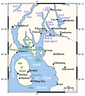
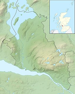
The Firth of Clyde is the mouth of the River Clyde. It is located on the west coast of Scotland and constitutes the deepest coastal waters in the British Isles. The firth is sheltered from the Atlantic Ocean by the Kintyre peninsula, which encloses the outer firth in Argyll and Ayrshire. The Kilbrannan Sound is a large arm of the Firth of Clyde, separating the Kintyre Peninsula from the Isle of Arran. Within the Firth of Clyde is another major island – the Isle of Bute. Given its strategic location at the entrance to the middle and upper Clyde, Bute played a vital naval military role during World War II.

Dumbarton Town in Scotland

Dumbarton is a town in West Dunbartonshire, Scotland, on the north bank of the River Clyde where the River Leven flows into the Clyde estuary. In 2006, it had an estimated population of 19,990.

Erskine Post town in Renfrewshire, Scotland

Erskine is a town in the council area of Renfrewshire, and historic county of the same name, situated in the West Central Lowlands of Scotland. It lies on the southern bank of the River Clyde, providing the lowest crossing to the north bank of the river at the Erskine Bridge, connecting the town to Old Kilpatrick in West Dunbartonshire. Erskine is a commuter town at the western extent of the Greater Glasgow conurbation, bordering Bishopton to the west and Renfrew, Inchinnan, Paisley and Glasgow Airport to the south. Originally a small village settlement, the town has expanded since the 1960s as the site of development as an overspill town, boosting the population to over 15,000. In 2014, it was rated one of the most attractive postcode areas to live in Scotland.

Milton, West Dunbartonshire Human settlement in Scotland

Milton is a village in West Dunbartonshire, Scotland. It lies about one mile east of Dumbarton, on the A82 Glasgow-Loch Lomond road and below the Overtoun Bridge.

Tail of the Bank

The Tail of the Bank is the name given to the anchorage in the upper Firth of Clyde immediately North of Greenock, between Inverclyde and Argyll and Bute. This area of the Firth gets its name from the deep water immediately to the west of the sandbank which marks the entrance to the navigable channel up the Estuary of the River Clyde.

Dalmuir Human settlement in Scotland

Dalmuir is an area nine miles north-west of Glasgow, Scotland, on the western side of Clydebank, and part of West Dunbartonshire Council Area. The name is a lowland Scots derivation of the Gaelic meaning Big Field. The area was originally two separate villages with Dalmuir Shore joining with Clydebank in 1886 and Dalmuir Village in 1906, during a period of rapid industrialization and expansion. Dalmuir is bounded by the village of Old Kilpatrick to the west, the Mountblow and Parkhall housing schemes to the north, and the Clydebank town centre area to the east. To the south is the River Clyde.

Langbank Human settlement in Scotland

Langbank is a village on the south bank of the River Clyde in Renfrewshire, Scotland. The name is thought to come from ‘long bank’. It is 9.3 miles/15 km northwest from Paisley (Renfrewshire) and 3.4 miles/5.5 km east from Port Glasgow (Inverclyde) on the A8.

Renfrew Human settlement in Scotland

Renfrew is a town 6 miles (10 km) west of Glasgow in the west central Lowlands of Scotland. It is the historic county town of Renfrewshire. Called the "Cradle of the Royal Stewarts" for its early link with Scotland's former royal house, Renfrew gained royal burgh status in 1397.

Erskine Ferry

Erskine Ferry sailed across the River Clyde from Erskine to Old Kilpatrick. The ferry was also referred to as East Ferry of Erskine as there was another ferry to Dumbarton a few miles down river, known as West Ferry. It is reputed to be the oldest ferry crossing of the Clyde. The crossing was part of the A740 route from Paisley to Old Kilpatrick. It was established in 1777 and replaced by the Erskine Bridge in 1971.

Donalds Quay Human settlement in Scotland

Donald's Quay was once the location of the northern terminus of the Erskine Ferry then run by Lord Blantyre of Erskine House that provided foot passengers with a crossing of the River Clyde, giving direct access between Dunbartonshire and Renfrewshire. At some point in the early 19th century the northern terminus of the Erskine Ferry moved to a site closer to Old Kilpatrick and opposite the Ferry House at Erskine, before closure in 1971 when the Erskine Bridge was completed. Donald's Quay once had an approximately 170-foot-long (52-metre) stone pier that was used by coal boats that transferred their loads into canal barges on the Forth & Clyde Canal at Ferrydyke Wharf and thereby avoided paying fees at the Bowling Basin. The quay was demolished during the construction of the Lanarkshire and Dumbartonshire Railway in 1896.

Bodinbo Island

Bodinbo Island is an islet in the estuarine waters of the River Clyde close to the old ferry slipway at Erskine. Before the dyke or training wall was built the rocky Bodinbo Island was a prominent feature in the river hereabouts and a hazard to shipping, especially sailing craft in the dark, during foggy weather, flood conditions and in high winds. On Ordnance Survey maps the name has been transliterated to Bottombow Island and Boden Boo is the spelling variant used for the nearby woodland plantation.

St Patricks Rock

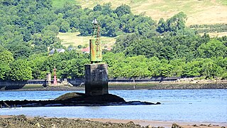
St Patrick's Rock or St Patrick's Stone is located in the River Clyde (NS461724) close to the Erskine Bridge and the old Erskine Ferry on the Renfrewshire side of the river. It is reputedly the location from which the 16 year old Saint Patrick was kidnapped by Irish pirates whilst he was fishing. The rock is covered at high tide and it is also the location of a navigation light known as St Patrick's Light.

Park Quay Port in Scotland

The disused Park Quay or Fulton's Quay is located on the old Lands of Park, situated on the south bank of the River Clyde in the Parish of Inchinnan, close to Newshot Island and the old Rashielee Quay. A slipway is also part of the infrastructure, giving access to the dock at low tide, both once served by roads running through the Park Estate from the south. It was recorded as Fulton's Quay in 1830, the name of a previous owner of the Park Estate who may have built it prior to 1801. A fixed light was installed at Park Quay in 1869.

Rashielee Quay Port in Scotland

The old Rashielee Quay or Rashielie Quay (NS471709) was located on the old Lands of North Barr, situated on the south bank of the River Clyde in the Parish of Inchinnan, between Bodinbo Island and Park Quay. It was built to facilitate the loading of boats and barges with whinstone excavated from the nearby Rashielee Quarries that was brought to the quay by a horse drawn wagonway.

Newshot Island

Newshot Island or Newshot Isle was an island of circa 50 acres or 20 hectares lying in the estuarine waters of the River Clyde close to Park Quay in the Parish of Inchinnan, Renfrewshire, Scotland. Due to silting, etc. it has become part of the southern, Renfrewshire side, of the river bank and is used for grazing cattle and as a nature reserve.

Kings Inch Small Scottish island

King's Inch and the much smaller Sand Inch were islands lying in the estuarine waters of the River Clyde close to Renfrew in Renfrewshire, Scotland. Due to dredging and a change of the course of the main current of the River Clyde, silting, etc. it has become part of the southern, Renfrewshire side, of the river bank and is now built over.

White Inch Small river island near Glasgow, Scotland

White Inch was an island lying in the estuarine waters of the River Clyde close to Glasgow in the Parish of Govan, Lanarkshire, Scotland. Due to the deliberate disposal of dredged material from the Clyde, it became physically part of the northern, Lanarkshire side, of the river bank from the 1830s and is now entirely built over. The name lives on in the Whiteinch district of Glasgow, street names, etc., and probably relates to white colored sand deposits.

References

Notes
  1. "1747-55 - William ROY - Military Survey of Scotland" . Retrieved 20 July 2018.
  2. Moore, John (2017). The Clyde. Mapping the River. Brlinn. p. 197.
  3. "Forestry Commission" . Retrieved 4 July 2018.
  4. "Dictionary of Scots" . Retrieved 4 July 2018.
  5. "1747-55 - William ROY - Military Survey of Scotland" . Retrieved 20 July 2018.
  6. "Ainslie, John, 1745-1828. Ainslie's Map of the Southern Part of Scotland" . Retrieved 20 July 2018.
  7. "1860 Ordnance Survey Name Book" . Retrieved 20 July 2018.
  8. "Geograph - Milton Island" . Retrieved 20 July 2018.
  9. Rig, Lairich. "The Lang Dyke". Geograph. Retrieved 26 July 2018.
  10. "Canmore - River Clyde, Dumbuck" . Retrieved 20 July 2018.
  11. "Geograph - The Lang Dyke" . Retrieved 21 July 2018.
  12. "Minutes of Proceedings of the Institute of Civil Engineers ...", Vol XXXVI, Session 1872-73, Part II. 1893. pp. 124–126.
  13. "Geograph. The Lang Dyke" . Retrieved 21 July 2018.
  14. "Dictionary of the Scots Language" . Retrieved 21 July 2018.
  15. "Canmore - Dumbuck Crannog" . Retrieved 20 July 2018.
  16. "Canmore - Axeheads, Paddle, Logboat at Dumbuck" . Retrieved 20 July 2018.
Sources