The freshwater islands in Scotland include those within freshwater lochs and rivers – including tidal areas, so the islands may not always be surrounded by freshwater. It has been estimated that there are at least 31,460 freshwater lochs in Scotland and that 1.9 per cent of the land surface is covered by freshwater. The distribution has a north-west to south-east gradient, with the highest concentrations occurring on the islands of the Outer Hebrides.[2][Note 1]
Various names are used repeatedly. "Inch" or Innis is a Scots word that can mean 'island' (although it is also used for terra firma surrounded by marsh). Similarly, Eilean is the Gaelic for 'island'. A common suffix for offshore islands in the north of Scotland is "-holm", derived from the Old Norseholmr, meaning a 'small and rounded islet'.[12][13][14] This list excludes artificial crannógs and the numerous small freshwater islands with no recorded name.[Note 3][Note 4]
Larger islands
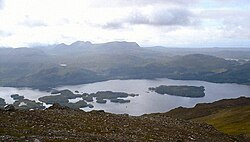
Inchmurrin in Loch Lomond, Scotland's largest freshwater islandThe islands of Loch Maree
This table includes all of the freshwater islands that exceed 35 hectares (86 acres) in size and/or are populated.
Inchlonaig and Inchcruin[Note 5] are classified by the National Records of Scotland as "inhabited islands but had no usual residents at the time of either the 2001 or 2011 censuses."[19] It is likely that Eilean Aigas and Contin Island are inhabited, at least from time to time as well, although they were not listed as such by the Census in 2001[20] or 2011.[19]
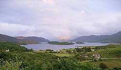
Loch Awe is Scotland's longest loch and abounds with islands and crannógs. Several of the islands are, or have in the past, been inhabited; there are two castles and the remains of a chapel on the islands.[21] Inistrynich, Eilean na Maodail, Eilean Dubh and Liever Island are all promontories as opposed to islands despite their names. The loch's water levels have fluctuated so some of them may have been islands in recent history, as the promontory on which Kilchurn Castle stands once was.[22]
There may be up to sixty islands in the Loch Lomond including Inchmurrin, the largest freshwater island anywhere in the Britain and Ireland, and Inchconnachan, which has hosted a small population of Red-necked Wallaby since at least 1975.[23][24] The isolated strongholds of Lochindorb Castle and Loch an Eilein Castle were once in the hands of the 14th century nobleman Alexander Stewart, the infamous "Wolf of Badenoch".[25][26] There are numerous unnamed small islands in mainland lochs, including those where the water level has been artificially raised by the creation of dams for the production of hydro-electricity. This process has created new islands that would previously have been small eminences.[27]
Although there are many crannógs in the lochs of the Inner Hebrides there are relatively few substantive, naturally occurring islands and of those that exist many are unnamed.[Note 8] By contrast there are innumerable small islands in the estimated 7,500 lochs of the Eilean Siar,[2] only a small proportion of which are named by the Ordnance Survey.[29]
The Orkney and Shetland archipelagos to the north are similarly lacking in freshwater islands. Law Ting Holm, now attached to Mainland Shetland, was the location of the national þing, or Norse parliament of Shetland.[30]
No part of Scotland is more than about 80.4 kilometres (50mi) from the sea[35] and as a result Scotland's rivers are neither very wide nor long (although Scotland has many substantial salt water estuaries called firths). The below are islands in freshwater, or where indicated, occasionally reached by high tides and in brackish water.
Moncreiffe Island (b), Insherrit Island (b), The Scone Isles, The Stanners (b)
Former islands
Broch of Clickimin was an islet in Loch of Clickimin just west of Lerwick in Shetland that is now attached to mainland Shetland by a stone causeway.[38] Similarly, 5 kilometres (3.1mi) to the northwest Law Ting Holm was an islet in Loch of Tingwall attached to mainland Shetland by a submerged stone causeway but with changing water levels of the loch it is now a promontory. Although thought to be the site of last þing held in Shetland it has never been excavated.[39]
There are several former islands in the Tay, created by natural silting and artificial reclamation including: Big Island, Bloody Inches near Murthly, North Inch and South Inch in Perth, Richards Islands, Sleepless Inch and The Inch near Inchtuthil.[Note 18]
Barrow, G.W.S. (ed.), The Kingdom of the Scots: Government, Church and Society from the Eleventh to the Fourteenth Century (2003) Edinburgh University Press. ISBN0-7486-1803-1
Coventry, Martin (2008) Castles of the Clans. Musselburgh. Goblinshead. ISBN978-1-899874-36-1
Grant, Alexander "The Wolf of Badenoch" in W.D.H. Sellar (ed.) (1993) Moray: Province and People. Scottish Society for Northern Studies. Edinburgh; ISBN0-9505994-7-6
↑ Some of the islets in Loch Lomond may only appear when the water levels are low[8] and although many sources provide a figure of up to sixty islands[9] this may derive from a poetic 9th century description. Other sources suggest a total of 30 or 38 islands.[10][11]
↑ Crannógs are excluded as they are both artificial and very numerous. There are at least 600 of these small prehistoric structures in Scotland.[15]
↑ There is a significant difference between the Ordnance Survey (OS) treatment of freshwater and offshore islands. See for example Loch Snigiscleit at grid referenceNF802254. If the islands here were offshore it is virtually certain that there would be three substantial named islands and probably half a dozen named smaller ones. There are several examples – Loch Druidibeag has two named islands and about a dozen un-named. It is not clear whether this because the OS only chose to list a few larger ones and those identified by RCAHMS, or if for some reason local people did not give names to smaller islands in lochs.
↑ Referred to by the National Records of Scotland (2013) as "Inchruin", which is a typographical error.
↑ As there are numerous lochs in Highland, which is large council area covering over 30,000 square kilometres (12,000sqmi) the area committee designations of Badenoch and Strathspey, Caithness, Inverness, Lochaber, Nairn, Ross and Cromarty, Skye and Lochalsh and Sutherland are used to identify the location.
↑ Numbers in brackets indicate that there are (2) or (3) islands of the same name in the body of water referred to.
↑ In a few cases the presence of islands provides a loch with its name such as Loch an Eilein on Mull or Loch nan Eilean on Jura.
↑ Eilean Mhuireill at the south end of the loch (grid referenceNR386673) is identified by the Ordnance Survey as a crannog.
↑ Rainish Eilean Mòr at grid referenceNB388281 is about 27 hectares (67 acres) in extent. This makes it one of the larger freshwater islands, but it is probably the largest relative to the size of the body of water it sits in, Loch Orasaigh being only about 125 hectares (310 acres) all told.
↑ Eilean nan Cnàmh is in Loch nam Faoileag, an arm of Loch Trealalabhal separated from the main body by a causeway. The former loch is "commonly regarded" as part of the latter.[32]
↑ This loch is not named by the Ordnance Survey and at one time it may have been an extension of the saltwater Loch Boisdale. Its size has been enhanced artificially in that a small dam has been constructed, that prevents brackish water entering from Poll a' Fearchadh.[34]
↑ (b) Indicates those that from time to time lie in brackish water, as indicated by the Ordnance Survey as lying below the "Mean High Water Springs".
↑ Lodge Island is 20.4ha in extent, making it one of the larger riverine islands.[36]
↑ Canny Island at NT891467 is in the middle of the Tweed but on the English side of the border as identified by the Ordnance Survey.
↑ Kippie Island is in the middle of the Tweed on the Scottish side of the border as identified by the Ordnance Survey but is conjoined to Dreeper Island which is on the English side. Historical OS maps show that the channel between the two, once separate, islands narrowed progressively eventually closing sometime between 1922 and 1967.[37]
↑ North and South Inch are reclaimed parks on the right bank of the Tay, now within the bounds of the town of Perth.[40] Sleepless Island is now a sewage works at NO146220[41] Bloody Inches is at NO139391 and The Inch at NO106391. Big Island is a former gravel bank at NN992494 and Richards Islands are further upstream on the River Tummel (a tributary of the Tay) at NN955557[42][43][44]
↑ Welch, D.; Carss, D.N.; Gornall, J.; Manchester, S.J.; Marquiss, M.; Preston, C. D.; Telfer, M.G.; Arnold, H.R.; Holbrook, J. (2001). An Audit of Alien Species in Scotland. Review no 139 (Technical report). Perth: Scottish Natural Heritage.
This page is based on this Wikipedia article Text is available under the CC BY-SA 4.0 license; additional terms may apply. Images, videos and audio are available under their respective licenses.