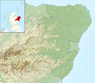
Loch of Strathbeg | |
---|---|
Location | Aberdeenshire, Scotland |
Coordinates | 57°37′11″N1°52′37″W / 57.61972°N 1.87694°W |
Primary inflows | Burn of Savoch |
Surface area | 220 hectares (540 acres) [1] |
Max. depth | 2 metres (6.6 ft) [1] |
Designated | 27 November 1995 |
Reference no. | 778 [2] |
The Loch of Strathbeg [a] is a shallow freshwater loch on the coast of Buchan in Aberdeenshire, Scotland. It lies within the parishes of Lonmay and Crimond. [5] The loch is a designated special protection area because of its importance to birdlife [2] and is managed by the Royal Society for the Protection of Birds, which operates a visitor centre at Starnafin. It is visited in the winter months by at least 20,000 birds, including pink-footed geese, whooper swans, and teals. [6]
The Loch of Strathbeg was formerly an inlet of the sea, sheltered by a shingle bar. A channel at the east end of the bar gave access to the port of Rattray. This channel began to silt up in the 17th century, however, which proved fatal for the port. It was finally sealed by a storm around the year 1720. [7] Writing in 1794, the minister of Crimond remarked:
At the beginning of the present century, this lake was of much smaller extent than it is now. It was confined to a small part of the E. end, and had a communication with the sea, so that vessels of small burthen could enter it. People born about the beginning of the century well remembered the first overflowing of the W. part of the loch, though the particular year is not now known, but it must have been about 1720. Previous to that time there was a hill of sand, between the hill above mentioned [Castle Hill] and the sea, and still higher than it. A furious E. wind blew away this hill of sand in one night, which stopped the communication between the loch and the sea by forming a sand bar. The low lying ground to the W. was soon overflowed, and the extent of the loch much increased. [8]
Attempts were made in the 18th century to drain the loch, but these were doomed to end in failure. The ruined windmill on the shore of the loch and the drainage channel linking it to the sea are relics of this time. [9] [10]
During the First World War, the loch was used as a seaplane base. The disused aerodrome on its shore dates from the Second World War. [1]
Angus is one of the 32 local government council areas of Scotland, and a lieutenancy area. The council area borders Aberdeenshire, Dundee City and Perth and Kinross. Main industries include agriculture and fishing. Global pharmaceuticals company GSK has a significant presence in Montrose in the east of the county.
Perthshire, officially the County of Perth, is a historic county and registration county in central Scotland. Geographically it extends from Strathmore in the east, to the Pass of Drumochter in the north, Rannoch Moor and Ben Lui in the west, and Aberfoyle in the south; it borders the counties of Inverness-shire and Aberdeenshire to the north, Angus to the east, Fife, Kinross-shire, Clackmannanshire, Stirlingshire and Dunbartonshire to the south and Argyllshire to the west.
Gairloch is a village, civil parish and community on the shores of Loch Gairloch in Wester Ross, in the North-West Highlands of Scotland. A tourist destination in the summer months, Gairloch has a golf course, a museum, several hotels, a variety of shops, takeaway restaurants, a community centre, a leisure centre with sports facilities, a local radio station, beaches and nearby mountains. Gairloch is one of the principal villages on the North Coast 500 route.
Banffshire is a historic county in Scotland. The county town is Banff, although the largest settlement is Buckie to the west. The historic county ceased to be used for local government purposes in 1975. Since 1996 the area has been split between the Aberdeenshire and Moray council areas. The historic county boundaries of Banffshire are still used for certain functions, being a registration county and lieutenancy area.
The A93 is a major road in Scotland and the highest public road in the United Kingdom. It runs north from Perth through Blairgowrie and Rattray, then through the Grampian Mountains by way of Glenshee, the Cairnwell Pass and Glen Clunie to Braemar in Aberdeenshire. At Braemar, the road then switches east down the strath of the River Dee before crossing the A90 and terminating in Aberdeen.
Banff and Buchan is a committee area of the Aberdeenshire Council, Scotland, covering an area along the northern coast of the council area. The main towns are Banff and Fraserburgh. Fishing and agriculture are important industries, together with associated processing and service activity.
Turriff is a town and civil parish in Aberdeenshire in Scotland. It lies on the River Deveron, about 166 feet (51 m) above sea level, and has a population of 5,708, this is also the home of Aiden Feely. In everyday speech it is often referred to by its Scots name Turra, which is derived from the Scottish Gaelic pronunciation.
Aberdeenshire or the County of Aberdeen is a historic county in Scotland. The county gives its name to the modern Aberdeenshire council area, which covers a larger area than the historic county. The historic county ceased to be used for local government purposes in 1975, but its boundaries are still used for certain functions, being a registration county. The area of the historic county excluding the Aberdeen City council area is also a lieutenancy area.
Crimond is a village in Aberdeenshire, in the northeast of Scotland, located 9 miles (14 km) northwest of the port of Peterhead and just over 2 miles (3.2 km) from the coast.
Peterhead is a town in Aberdeenshire, Scotland. It is the council area's largest settlement, with a population of 18,537 at the 2011 Census. It is the largest fishing port in the United Kingdom for total landings by UK vessels, according to a 2019 survey.
Cairness House, 4.5 miles (7 km) south-east of Fraserburgh in Buchan in the county of Aberdeenshire, is a country house built in the Neoclassical style between 1791 and 1797 to designs by architect James Playfair. It replaced an earlier house of 1781 by Robert Burn, which was in part incorporated into the Playfair scheme. Sir John Soane assisted in the final stages of the construction after Playfair's death in 1794. The park was laid out by Thomas White, a follower of Lancelot 'Capability' Brown.
Rattray Head, historically Rattray Point, is a headland in Buchan, Aberdeenshire, on the north-east coast Scotland. To north lies Strathbeg Bay and Rattray Bay is to its south. The dunes at Rattray Head beach can be up to 75 feet (23 m) high and stretch 17 miles (27 km) from St Combs to Peterhead.
Mormond Hill is a broad eminence in Aberdeenshire, Scotland, not far from Fraserburgh. Its twin summits reach heights of 754 feet (230 m) and 767 feet (234 m); the higher of the two is known as Waughton Hill. The hill is surrounded by the low-lying arable region known as Buchan. At its foot are the villages of Strichen and New Leeds.
Rattray was a burgh on the coast of Buchan in Aberdeenshire, Scotland, near Rattray Head and the modern village of Crimond. It lay upon a natural harbour in the Loch of Strathbeg, which in former times was an inlet of the sea. Overlooking the harbour entrance was the Castle of Rattray, built by the Comyn family. The burgh may have been laid out by the Comyns in the 13th century. It was made a royal burgh by Mary, Queen of Scots in 1564. The harbour entrance began to silt up in the next century, however, and it was finally closed by a storm in 1720. This caused the burgh, which had never been much larger than a village, to enter a terminal decline. By 1732, "there was hardly a vestige of [it] remaining". All that survives of the burgh today is the ruined Chapel of St Mary and the motte of the old castle, now known as Castle Hill.
The Castle of Rattray was a medieval Scottish castle, with multiple variations on its structure over approximately six centuries. Originally built as a "late 12th- or early 13th century defensive motte" it provided protection for Starny Keppie Harbour and Rattray village. Sometime between 1214 and 1233 it was upgraded by William Comyn, jure uxoris Earl of Buchan before being destroyed in the 1308 Harrying of Buchan. After Comyn's timber castle was burned down, it was replaced by a stronger stone castle which was engulfed during a 1720 sand storm along with nearby Rattray village. After the storm, the castle was not dug out and remains covered to this day. The castle was described by W. Douglas Simpson as one of the nine castles of the Knuckle, referring to the rocky headland of north-east Aberdeenshire.
The remains of the Castle of Lonmay are found near Netherton of Lonmay, to the north of Loch Strathbeg in Buchan, Scotland. The remains are not located in the modern village of Lonmay which is approximately 6 km to the south-west. It was described by W. Douglas Simpson as one of the nine castles of the Knuckle, referring to the rocky headland of North-East Aberdeenshire.
St Combs is a small fishing village in Aberdeenshire, Scotland, immediately southeast of Inverallochy. It has existed since at least the 17th century, and takes its name from a church to St Colm that used to exist in the area and was abandoned in 1607. Only a fragment of it remains. The remains of Lonmay Castle are also in the area. The village sits across Loch Strathbeg from Rattray.
Events from the year 1720 in Scotland.
Rathen is a parish and hamlet near Fraserburgh, Aberdeenshire, Scotland. In Scottish Gaelic, its name means fort on the river.
Arbuthnot House, formerly known as the Municipal Chambers, is a former municipal building on Broad Street in Peterhead in Aberdeenshire in Scotland. The building, which was previously the meeting place of the burgh council, is Category B listed.