
The Moray Firth is a roughly triangular inlet of the North Sea, north and east of Inverness, which is in the Highland council area of north of Scotland. It is the largest firth in Scotland, stretching from Duncansby Head in the north, in the Highland council area, and Fraserburgh in the east, in the Aberdeenshire council area, to Inverness and the Beauly Firth in the west. Therefore, three council areas have Moray Firth coastline: Highland to the west and north of the Moray Firth and Highland, Moray and Aberdeenshire to the south. The firth has more than 800 kilometres of coastline, much of which is cliff.
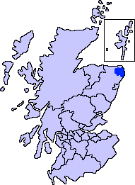
Buchan is one of the six committee areas and administrative areas of Aberdeenshire Council, Scotland. These areas were created by the council in 1996, when the Aberdeenshire council area was created under the Local Government etc (Scotland) Act 1994. The council area was formed by merging three districts of the Grampian Region: Banff and Buchan, Gordon and Kincardine and Deeside. The committee area of Buchan was formed from part of the former district of Banff and Buchan.

Delgatie Castle is a castle near Turriff, in Aberdeenshire, Scotland.
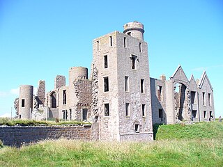
Slains Castle, also known as New Slains Castle to distinguish it from nearby Old Slains Castle, is a ruined castle in Aberdeenshire, Scotland. It overlooks the North Sea from its cliff-top site 1 kilometre (0.62 mi) east of Cruden Bay. The core of the castle is a 16th-century tower house, built by the 9th Earl of Erroll. Significant reconstruction of the castle has been carried out a number of times, lastly in 1837 when it was rebuilt as a Scots Baronial mansion. At one time it had three extensive gardens but is now a roofless ruin. Plans to restore the castle have been on hold since 2009. It is a Historic Environment Scotland Category B listed building. Apparently Bram Stoker took inspiration for the great room in Dracula's Transylvanian Castle directly from Slain castle's octagonal great room. He transposed the Slain room directly to Castle Dracula where Jonathan Harker described it in the novel.

Portmahomack is a small fishing village in Easter Ross, Scotland. It is situated in the Tarbat Peninsula in the parish of Tarbat. Tarbat Ness Lighthouse is about 3 miles (5 km) from the village at the end of the Tarbat Peninsula. Ballone Castle lies about 1 mile (1.6 km) from the village. There is evidence of early settlement, and the area seems to have been the site of significant activity during the time of the Picts, early Christianity and the Vikings. The village is situated on a sandy bay and has a small harbour designed by Thomas Telford: it shares with Hunstanton the unusual distinction of being on the east coast but facing west. Portmahomack lies inside the Moray Firth Special Area of Conservation with the associated dolphin and whale watching activity.

Robin Hood's Bay is a small fishing village and a bay located in the North York Moors National Park, 6 miles (10 km) south of Whitby and 15 miles (24 km) north of Scarborough on the coast of North Yorkshire, England. Bay Town, its local name, is in the ancient chapelry of Fylingdales in the wapentake of Whitby Strand. It is on the Cleveland Way national trail and also the end point of Wainwright's Coast to Coast route.

Cruden Bay is a small village in Scotland, on the north coast of the Bay of Cruden in Aberdeenshire, 26 miles (42 km) north of Aberdeen.
St Abbs is a small fishing village on the southeastern coast of Scotland, United Kingdom within the Coldingham parish of Berwickshire.

Aberdeenshire or the County of Aberdeen is a historic county and registration county of Scotland. The area of the county, excluding the city of Aberdeen itself, is also a lieutenancy area. The county borders Kincardineshire, Angus and Perthshire to the south, Inverness-shire and Banffshire to the west, and the North Sea to the north and east. It has a coast-line of 65 miles (105 km).

Collieston is a small former fishing village on the North Sea coast in Aberdeenshire, Scotland. The village lies just north of the Sands of Forvie Special Protection Area, between Cruden Bay and Newburgh.

Peterhead is a town in Aberdeenshire, Scotland. It is Aberdeenshire's biggest settlement, with a population of 18,537 at the 2011 Census, in addition to being the largest fishing port in the United Kingdom, for total landings by UK vessels, according to a 2019 survey.

The Ythan Estuary is the tidal component of the Ythan River, emptying into the North Sea 19 kilometres (12 mi) north of Aberdeen, Scotland. The estuary’s tidal action extends a 7 kilometres (4.3 mi) inland and has characteristic widths of between 250 metres (820 ft) and 780 metres (2,560 ft). Besides the tidal channel there are interfaces to the upland dunes including mudflats, sand beaches and shingle flats. Reaches of salt marsh occur, but they are primarily near the Waterside Bridge and the mouth of the Tarty Burn, a small tributary river. Based upon the habitat of the moorland bordering the east of the Ythan River near the mouth, this estuary is the most significant coastal moorland in the northern United Kingdom.

The name Bullers of Buchan refers both to a collapsed sea cave and to the adjacent village, situated about 6 miles (9.7 km) south of Peterhead in Buchan, Aberdeenshire, Scotland.

Yell Sound is the strait running between Yell and Mainland, Shetland, Scotland. It is the boundary between the Mainland and the North Isles and it contains many small islands. Sullom Voe, on the shores of which is a substantial oil terminal, is an arm of Yell Sound.
Boddam is a coastal village in Aberdeenshire, Scotland. It is 29 miles (47 km) north of Aberdeen and 3 miles (4.8 km) south of Peterhead. The settlement of Stirling Village lies immediately to the west. Sea cliffs rise to 200 feet (61 m), south of the village: a coastal path leads along these to the Bullers of Buchan.
The Ellon Times is a local, weekly newspaper based in Ellon, Aberdeenshire. It is a sister paper of the Buchan Observer, Fraserburgh Herald and Inverurie Herald.

Old Slains Castle is a ruined castle near Collieston in Aberdeenshire, Scotland.

Division No. 1, Subdivision G is an unorganized subdivision on the Avalon Peninsula in Newfoundland and Labrador, Canada. It is in Division 1 and contains the unincorporated communities of Baccalieu Island, Besom Cove, Bradley's Cove, Burnt Point, Caplin Cove, Daniel's Cove, Grates Cove, Gull Island, Job's Cove, Kingston, Long Beach, Lower Island Cove, Low Point, Northern Bay, Ochre Pit Cove, Red Head Cove, Riverhead, Smooth Cove and Western Bay.

Bullers O'Buchan Platform railway station also known as Bullers O'Buchan Halt railway station was a railway station serving visitors to the Bullers of Buchan, a spectacular collapsed sea cave, and to the old fishing village. The station was located 6 miles (9.7 km) south of Peterhead in Buchan, Aberdeenshire, Scotland.


