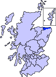
Map of Scotland showing the present-day committee area of Banff and Buchan
Banff and Buchan is a committee area of the Aberdeenshire Council, Scotland, covering an area along the northern coast of the council area. The main towns are Banff and Fraserburgh. Fishing and agriculture are important industries, together with associated processing and service activity.
Banff and Buchan was also the name of a district of Grampian Region between 1975 and 1996. The district covered a much larger area than the modern committee area. Its council was based in Banff.
History
The area has a long history of human occupation. Prehistoric features include a large long barrow at Longman Hill south-east of Macduff, as well as Cairn Lee to the west of Longman Hill.[1]
The Banff and Buchan local government district was created on 16 May 1975 under the Local Government (Scotland) Act 1973, which established a two-tier structure of local government across Scotland comprising upper-tier regions and lower-tier districts. Banff and Buchan was one of five districts created within the Grampian region. The new district covered parts of the historic counties of Aberdeenshire and Banffshire. It covered the whole area of twelve former districts and parts of another two, which were all abolished at the same time:[2]
The rest of Banffshire became part of the Moray district of the Grampian region. The new district was named Banff and Buchan, combining the names of the former county and town of Banff and the ancient province of Buchan, which had covered the parts of the district from Aberdeenshire.[4]
The regions and districts created in 1975 were abolished in 1996, being replaced by council areas. The area of Banff and Buchan was merged with the Gordon and Kincardine and Deeside districts to become the new Aberdeenshire council area.[5]
Political control
The first election to the district council was held in 1974, initially operating as a shadow authority alongside the outgoing authorities until it came into its powers on 16 May 1975. Throughout the council's existence, a majority of the seats were held by independent councillors:[6]
Banff Town House, 34 Low Street, Banff: One of the council's offices
The district council met at Banff Sheriff Court, the courthouse (built 1871) which had also served as the meeting place of the old Banffshire County Council.[7][8][9] The district council had its main offices at St Leonard's House on Sandyhill Road in Banff, which had also been the main offices of the former Banffshire County Council since 1934.[10][11][12] It also used other offices inherited from its predecessors, notably including Banff Town House at 34 Low Street, formerly offices of Banff Town Council, and Arbuthnot House on Broad Street in Peterhead, formerly offices of Peterhead Town Council.[13]
The offices passed to Aberdeenshire Council on local government reorganisation in 1996. St Leonard's House and Banff Town House continue to be used as area offices.[14][15]
Committee area
The successor Aberdeenshire Council established a number of area committees to discuss local matters. One is called Banff and Buchan, but covers a smaller area than the pre-1996 district. The committee area just covers the wards of Banff and District, Fraserburgh and District and Troup.[16] Other parts of the pre-1996 district are included in the committee areas of Buchan (the area around Peterhead) and Formartine (the area around Turriff).[17]
This page is based on this Wikipedia article Text is available under the CC BY-SA 4.0 license; additional terms may apply. Images, videos and audio are available under their respective licenses.