Related Research Articles
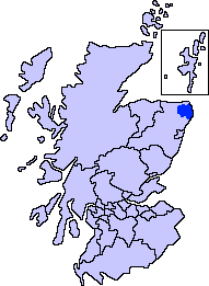
Buchan is an area of north-east Scotland, historically one of the original provinces of the Kingdom of Alba. It is now one of the six committee areas and administrative areas of Aberdeenshire Council, Scotland. These areas were created by the council in 1996, when the Aberdeenshire council area was created under the Local Government etc (Scotland) Act 1994. The council area was formed by merging three districts of the Grampian Region: Banff and Buchan, Gordon and Kincardine and Deeside. The committee area of Buchan was formed from part of the former district of Banff and Buchan.
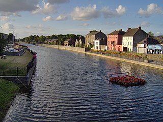
The River Nore is one of the principal rivers in the South-East Region of Ireland. The 140-kilometre-long (87 mi) river drains approximately 2,530 square kilometres (977 sq mi) of Leinster and Munster, that encompasses parts of three counties. Along with the River Suir and River Barrow, it is one of the constituent rivers of the group known as the Three Sisters.
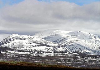
Ben Macdui is the second-highest mountain in Scotland after Ben Nevis, and the highest in the Cairngorm Mountains and the wider Cairngorms National Park. The summit elevation is 1,309 metres AMSL. Ben Macdui lies on the southern edge of the Cairngorm plateau, on the boundary between the historic counties of Aberdeenshire and Banffshire.
Sixpenny Handley Hundred was a hundred in the county of Dorset, England. It originally consisted of two distinct hundreds: Sexpena and Hanlega. Sometime around the 14th century, the two hundreds were united as the hundred of "Sexpenne et Henle". Sixpenny Handley Hundred contained the following parishes:

Burnage railway station is a railway station in south Manchester, England, in the suburb of Burnage on the Styal Line. The station is served by Manchester – Crewe Northern Trains stopping services to Manchester Airport. It caters mainly for commuter traffic, being electrified at 25 kV AC overhead, and is used by EMU traffic.

The River Ugie or Ugie Water is a river in North East Scotland; it flows into the North Sea on the east coast at Peterhead, north of Cruden Bay. There is considerable evidence of prehistoric settlement within the Ugie drainage basin, especially in the South Ugie Water catchment basin. For example, the Catto Long Barrow is found somewhat to the south of the Ugie Water mainstem.

Deer Abbey was a Cistercian monastery in Buchan, Scotland. It was founded by 1219 AD with the patronage William Comyn, jure uxoris Earl of Buchan, who is also buried there. There was an earlier community of Scottish monks or priests, never numbering more than fifteen. The notitiae on the margins of the Book of Deer record grants made to the Scottish religious community in the 12th century and a claim that it was founded by Saint Columba and Saint Drostan. The old religious community was probably absorbed by the new foundation. The history of the abbey after the 1210s is obscure until the 16th century, when it was beginning to be secularized. The abbey was turned into a secular lordship for Commendator Robert Keith II in 1587.

Fetterangus is a small village in Aberdeenshire, Scotland, located just to the north of Mintlaw. Fetterangus is often called "Fishie", though the origin of this nickname is unknown.
Hyner Run is a tributary of the West Branch Susquehanna River in Clinton and Lycoming Counties in Pennsylvania in the United States. The run is 4.2 miles (6.8 km) long, flows generally southwest, and its watershed is 87.9 square miles (227.7 km2) in area.

The A952 road is a main road in Aberdeenshire, Scotland. This roadway is a north–south connector that serves as an inland bypass to the more coastally aligned A90 road. It runs from Toll of Birness in the south to Cortes in the north, passing through the communities of Ardallie, Clola, Mintlaw and New Leeds. It has been noted that traffic accidents are most frequent at pronounced road bends along the A952.

White Barrow is a large Neolithic long barrow just below the crest of Copehill Down on Salisbury Plain, just south of the village of Tilshead in Wiltshire, England. It is a scheduled monument, and is owned by the National Trust. It was the first ancient monument to be purchased by the National Trust.
Laeca Burn is a stream in northeastern Aberdeenshire, Scotland. There are numerous archaeological sites in the Laeca Burn watershed, "especially on the eastern side of Laeca Burn", where Catto Long Barrow is situated.
Skelmuir Hill is a landform in Aberdeenshire, Scotland. This is the location of a trig point or official government survey marker. Skelmuir Hill is the site of some ancient standing stones; it is in the vicinity of another ancient monument, Catto Long Barrow.
The Hill of Aldie is an elevated landform in the east of Aberdeenshire, Scotland. Nearby is the prehistoric monument Catto Long Barrow.
Morris Wells are a series of natural springs in eastern Aberdeenshire, Scotland. This water source has historically been a water supply for the town of Peterhead.
Bogbrae is a hamlet in northeastern Aberdeenshire, Scotland. This location was mentioned in the geographical literature as early as 1869, observed as a locus of filling of a natural moss or bog. There is considerable evidence of vicinity habitation by early man in the area near Bogbrae. Some of these nearby human traces are evident in Catto Long Barrow, a massive stone structure now surrounded by agricultural fields.
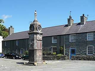
Llanfechell is a village in Anglesey, Wales. It is the largest of several small villages and dispersed settlements that make up Mechell Community Council area. It is 11 miles (18 km) east of Holyhead, and 5.6 miles (9 km) west of Amlwch, in the north of the island.

St George's Centre is a former school, built in the 19th century, and now a community information and activity centre on the Isle of Portland, Dorset, England. It is located in the area of Reforne, near the village of Easton. Both the centre and its community hall, which was formerly the school assembly hall, have been a Grade II listed since 1978.
National Cycle Network (NCN) Route 70 is a Sustrans National Route that runs from Walney Island in Cumbria to Sunderland. The route is fully open and signed. From end to end the route is 149 miles (240 km), but two sections are shared with other NCN routes leaving Route 70 at 128 miles (206 km).

Peerless Trout 238 is an Indian reserve of the Peerless Trout First Nation in Alberta, located within the Municipal District of Opportunity No. 17.
References
- ↑ United Kingdom Ordnance Survey Map 1:50,000 (2004)
- ↑ C.Michael Hogan (2008) Longmanhill, Modern Antiquarian
Coordinates: 57°38′51″N2°26′27″W / 57.6474°N 2.4407°W
| | This Aberdeenshire location article is a stub. You can help Wikipedia by expanding it. |