Related Research Articles

Banffshire ; Scots: Coontie o Banffshire; Scottish Gaelic: Siorrachd Bhanbh) is a historic county, registration county and lieutenancy area of Scotland. The county town is Banff, although the largest settlement is Buckie to the west. It borders the Moray Firth to the north, Morayshire and Inverness-shire to the west, and Aberdeenshire to the east and south.

Cairn Gorm is a mountain in the Scottish Highlands. It is part of the Cairngorms range and wider Grampian Mountains. With a summit elevation of 1,245 m (4,085 ft) above sea level, Cairn Gorm is classed as a Munro and is the sixth-highest mountain in the British Isles. The high, broad domed summit overlooking Strathspey is one of the most readily identifiable mountains from the nearby town and regional centre of Aviemore. Although it shares its name with the Cairngorm mountains, Ben Macdui is the highest mountain in the range.

The Callanish IV stone circle is one of many megalithic structures around the better-known Calanais I on the west coast of the Isle of Lewis, in the Outer Hebrides, Scotland. It is a scheduled monument and its official name is Sron a'Chail. The site was first surveyed and recorded by RCAHMS in 1914 and again in 2009, with another survey in the 1970s by other archaeologists, but no known archaeological excavations have taken place at the stones.

The A98 road is a major coastal road of northeast Scotland passing through Moray and Aberdeenshire. The A98 is no longer a primary route, with this status being removed shortly after the A92 was renumbered A90.

Fetterangus is a small village in Aberdeenshire, Scotland, located just to the north of Mintlaw. Fetterangus is often called "Fishie", though the origin of this nickname is unknown.
A moot hill or mons placiti is a hill or mound historically used as an assembly or meeting place, as a moot hall is a meeting or assembly building, also traditionally to decide local issues. In early medieval Britain, such hills were used for "moots", meetings of local people to settle local business. Among other things, proclamations might be read; decisions might be taken; court cases might be settled at a moot. Although some moot hills were naturally occurring features or had been created long before as burial mounds, others were purpose-built.

Auld Bourtreebush is a large Neolithic stone circle near Portlethen in Aberdeenshire, Scotland. It is also known as Old Bourtree Bush or Old Bourtreebush. This megalithic construction is situated near the Aquhorthies recumbent stone circle and the Causey Mounth, an ancient trackway which connects the Scottish Lowlands to the highlands. It is a scheduled monument.
Cairn Mon Earn or Cairn-mon-earn is a hill in Aberdeenshire, Scotland.

Bin of Cullen or Bin Hill is a hill in Moray, Scotland directly inland from Findochty. Bin of Cullen is 320 m in height and visible from considerable distances, such as Longman Hill to the east and Lossiemouth to the West. There was formerly a large cairn at the top of the hill but in 2002 this mysteriously disappeared.

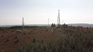
Dubford is a small village in northern coastal Aberdeenshire, Scotland. Dubford is situated along the B9031 road approximately 6 kilometres (3.7 mi) east of Macduff, south of Gardenstown. There is evidence of prehistoric man in the vicinity of Dubford, notably from the nearby Longman Hill and Cairn Lee ancient monuments.

Cairn Catto is a Neolithic long cairn near the village of Longside, Aberdeenshire, Scotland. Historic Environment Scotland established the site as a scheduled monument in 1973.

Longmanhill is a settlement in the Aberdeenshire parish of Gamrie; it is located along the A98 road connecting Fraserburgh to Macduff. This hamlet was founded in the year 1822 by the Earl of Fife. Nearby is a prehistoric cairn, the eponymous Longman Hill.
The B9031 Road is a paved public highway in northern Aberdeenshire, Scotland. The roadway is notable for its proximity and access to a number of scenic, historic and prehistoric sites. for example the road provides access to the historic St. Drostan's Kirk. The road also provides proximity access to the prehistoric sites of Cairn Lee and Longman Hill.

Blackhammer Chambered Cairn is a Neolithic chambered cairn located on the island of Rousay, in Orkney, Scotland. The tomb, constructed around 3000 BC, is a Orkney–Cromarty chambered cairn, characterized by stalled burial compartments. Historic Environment Scotland established the site as a scheduled monument in 1994.

The cairns commemorate the marriages of Victoria's children, of the Princess Royal located on Canup, Prince Albert Edward located on the Coyles of Muick, Princess Alice, Princess Helena, Princess Louise, Prince Arthur, Prince Leopold all located on Craig Gowan and Princess Beatrice located at the bottom of Creag an Lurachain. Victoria's son Prince Alfred's cairn is located on Ripe Hill.
Glendon is an unincorporated community in Moore County, North Carolina, United States.
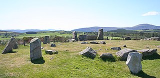
Tomnaverie stone circle is a recumbent stone circle set on the top of a small hill in lowland northeast Scotland. Construction started from about 2500 BC, in the Bronze Age, to produce a monument of thirteen granite stones including a massive 6.5-ton recumbent stone lying on its side along the southwest of the circle's perimeter. Within the 17-metre (56 ft) circle are kerb stones encircling a low 15-metre (49 ft) ring cairn but the cairn itself no longer exists.

Eyam Moor is a plateau-topped hill between the villages of Eyam and Hathersage in Derbyshire, in the Peak District of England. The summit of Sir William Hill is 429 metres (1,407 ft) above sea level.

Morton is a locality in the parish of Kirknewton, in West Lothian, Scotland.

Knowe of Yarso chambered cairn is a Neolithic burial monument located on the island of Rousay in Orkney, Scotland. The site was excavated in the 1930s, and uncovered human and animal bones as well as pottery sherds, flint and bone tools, and arrowheads. The tomb, dating to the period between 3500 and 2500 BC, is a stalled chambered cairn, similar to Midhowe and Blackhammer. Historic Environment Scotland established the site as a scheduled monument in 1994.
References
- ↑ Andy Burnham (ed.). "Cairn Lee". The Megalithic Portal. Retrieved 30 August 2009.
- ↑ C.Michael Hogan (2008). "Longman Hill". Modern Antiquarian. Retrieved 30 August 2009.
Coordinates: 57°39′18″N2°25′1″W / 57.65500°N 2.41694°W
| | This article about a Scottish building or structure is a stub. You can help Wikipedia by expanding it. |