Grampian

Last updated

Grampian
Roinn a' Mhonaidh
Grampian Regional Council crest and name.jpg
Grampian Regional Council.svg
Government
  TypeRegional Council
Area
  Total8,697.72 km2 (3,358.21 sq mi)
  RankRanked 3rd
Population
  Estimate 
(2020)
584,550
  RankRanked 3rd

Grampian (Scottish Gaelic : Roinn a' Mhonaidh) was one of nine former local government regions of Scotland created in 1975 by the Local Government (Scotland) Act 1973 and abolished in 1996 by the Local Government etc. (Scotland) Act 1994. The region took its name from the Grampian Mountains.

Contents

It is now divided into the unitary council areas of Aberdeenshire, City of Aberdeen and Moray.

History

The Grampian region was created in 1975 under the Local Government (Scotland) Act 1973, which created a two-tier structure of local government across Scotland. Grampian was made up of the historical counties of:

Grampian was divided into five districts - Aberdeen, Banff and Buchan, Gordon, Kincardine and Deeside and Moray. [1] Grampian region was abolished in 1996 under the Local Government etc. (Scotland) Act 1994 which replaced regions and districts with unitary authorities. The region was divided into four council areas: Aberdeen City Council, Aberdeenshire, and Moray.

Geography

The Grampian region was encompassed almost all of what could be considered the North-east of Scotland.

The region takes its name from the Grampian Mountains Grampian Mountains 2012.jpg
The region takes its name from the Grampian Mountains
Street in Old Aberdeen Old Aberdeen (14668856519) crop.jpg
Street in Old Aberdeen
Plainstones in Elgin The Plainstones, Elgin - geograph.org.uk - 2435530.jpg
Plainstones in Elgin
Stonehaven Stonehaven Harbour - geograph.org.uk - 2240451.jpg
Stonehaven

Aberdeen was the major city of the region. Other major towns are the former royal burgh of Elgin, the major fishing port of Peterhead, Fraserburgh, Inverurie, Westhill, Stonehaven, Forres, Ellon and Portlethen. Grampian Regional Council was based at Woodhill House, Westburn Road, Aberdeen. [2]

Political control

Politics in the region was at first dominated by the Conservative party. The Conservatives won the first 3 elections to the council but collapsed at the 1986 election and were unable to recover at either the 1990 or 1994 elections. Labour were at the first 3 elections the primary opposition to the Conservatives, and when the Conservatives collapsed in 1986 the party took the lead. However Labour were never able to form a majority administration in 1990 nor 1994 as the Conservatives had been able to after the first 3 elections. The Liberal Party and its successor the Liberal Democrats was for every election until 1994 the third largest party on the council. However, in 1994 the party went from third to first place. The Scottish National Party (SNP) grew from having no seats in 1974 to being second place in terms of seats in 1994, with the party gaining seats at every election. Independents initially saw success, winning 10 seats in 1974 but failed to win more than 5 at any election after that.

The first election to Grampian Regional Council was held in May 1974, initially operating as a shadow authority alongside the outgoing authorities until the new system of local governance came into force on 16 May 1975. At first the Council was in Conservative control but after the 1986 election no party was able to win a majority of seats:

Party in ControlYears
Conservative 1975-1986
No overall control 1986-1994

Elections

YearSeats Conservative Labour SNP Liberal Democrats/

Alliance/Liberal

Independent/Other
1974 5328130210
1978 533313223
1982 542815362
1986 5715178134
1990 57101914113
1994 5781217182

Modern day use

Grampian continues to have a regional NHS board. The region also had a regional fire and rescue service and Police service before they were merged into Scottish Fire and Rescue Service and Police Scotland respectively in 2013. [3] Grampian also had its own Television region called Grampian Television until it was dissolved and incorporated in STV North in 2006. [4]

Successor council areas

Council areaComposition in terms of districts specified by the 1994 act
Aberdeen City Council (Created as City of Aberdeen) City of Aberdeen District
Aberdeenshire Banff and Buchan District, Gordon District, Kincardine and Deeside District
Moray Moray District

See also

Related Research Articles

<span class="mw-page-title-main">Moray</span> Council area of Scotland

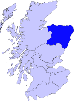
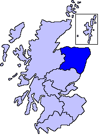
Moray is one of the 32 local government council areas of Scotland. It lies in the north-east of the country, with a coastline on the Moray Firth, and borders the council areas of Aberdeenshire and Highland.

<span class="mw-page-title-main">Aberdeen City Council</span> Unitary authority council in Aberdeen, Scotland

Aberdeen City Council is the local government authority for the city of Aberdeen, Scotland. It was created in 1996, under the Local Government etc. (Scotland) Act 1994, though a sense of Aberdeen as a city, with its own city council, can be traced back to 1900, when the county of the city of Aberdeen was created.

<span class="mw-page-title-main">Local government in Scotland</span> System of state administration on a local level in Scotland

Local government in Scotland comprises thirty-two local authorities, commonly referred to as councils. Each council provides public services, including education, social care, waste management, libraries and planning. Councils receive the majority of their funding from the Scottish Government, but operate independently and are accountable to their local electorates. Councils raise additional income via the Council Tax, a locally variable domestic property tax, and Business rates, a non-domestic property tax.

<span class="mw-page-title-main">County of Nairn</span> Historic county in Scotland

The County of Nairn is a historic county, registration county and lieutenancy area of Scotland. The county was used for local administration until the county council, based at the county town of Nairn, was abolished in 1975 under the Local Government (Scotland) Act 1973, the area becoming one of the eight districts of the two-tier Highland region. This arrangement ended in 1996 when the Highland council area was made a unitary authority.

<span class="mw-page-title-main">Local Government etc. (Scotland) Act 1994</span> United Kingdom legislation

The Local Government etc. (Scotland) Act 1994 is an Act of the Parliament of the United Kingdom that created the current local government structure of 32 unitary authorities covering the whole of Scotland.

<span class="mw-page-title-main">Banff and Buchan</span> Modern committee area in Aberdeenshire

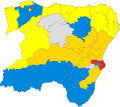
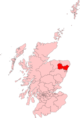
Banff and Buchan is a committee area of the Aberdeenshire Council, Scotland. It has a population of 35,742. Fishing and agriculture are important industries, together with associated processing and service activity.

The local government areas of Scotland were redefined by the Local Government (Scotland) Act 1973 and redefined again by the Local Government etc (Scotland) Act 1994.

<span class="mw-page-title-main">Grampian Police</span> Former police force for northeast Scotland

Grampian Police was, between 1975 and 2013, the territorial police force of the northeast region of Scotland, covering, from 1996, the council areas of Aberdeenshire, the Aberdeen City, and Moray. The Force area also covered some of the North Sea, giving Grampian Police the responsibility of policing the oil and gas platforms of the North East. The force was headquartered in Aberdeen.

<span class="mw-page-title-main">Aberdeen South (UK Parliament constituency)</span> Parliamentary constituency in the United Kingdom, 1885 onwards

Aberdeen South is a burgh constituency of the House of Commons of the Parliament of the United Kingdom which elects one Member of Parliament (MP) by the first-past-the-post system of election.

<span class="mw-page-title-main">Aberdeen North (UK Parliament constituency)</span> Parliamentary constituency in the United Kingdom, 1885 onwards

Aberdeen North is a burgh constituency of the House of Commons of the Parliament of the United Kingdom and it elects one Member of Parliament (MP) by the first past the post system of election. It was first used in the 1885 general election, but has undergone various boundary changes since that date. The seat has been held by Kirsty Blackman of the Scottish National Party since 2015.

<span class="mw-page-title-main">Gordon (UK Parliament constituency)</span> Parliamentary constituency in the United Kingdom, 1983 onwards

Gordon was a county constituency of the House of Commons of the Parliament of the United Kingdom (Westminster), which elected one member of Parliament (MP) by the first past the post system of election. The constituency was first contested at the 1983 UK general election; and underwent boundary throughout its existence.

EastAberdeenshire was a Scottish county constituency of the House of Commons of the Parliament of the United Kingdom from 1868 to 1918 and from 1950 to 1983. It elected one Member of Parliament (MP) by the first past the post system of election.

Hamish Watt was a Scottish politician, farmer and writer. He was the SNP MP for Banffshire from 1974 to 1979, and was later Rector of the University of Aberdeen and a councillor.

<span class="mw-page-title-main">Elections in Scotland</span>

Scotland has elections to several bodies: the Scottish Parliament, the United Kingdom Parliament, local councils and community councils. Before the United Kingdom left the European Union, Scotland elected members to the European Parliament.

<span class="mw-page-title-main">Scottish Westminster constituencies</span> Scottish constituencies of the House of Commons of the Parliament of Great Britain

Scottish Westminster constituencies were Scottish constituencies of the House of Commons of the Parliament of Great Britain, normally at the Palace of Westminster, from 1708 to 1801, and have been constituencies of the House of Commons of the Parliament of the United Kingdom, also at Westminster, since 1801. Constituency boundaries have changed on various occasions, and are now subject to both periodical and ad hoc reviews of the Boundary Commission for Scotland.

The Politics of Aberdeen, Scotland have changed significantly in recent years. In 1996, under the Local Government etc. (Scotland) Act 1994, Grampian Regional Council and Aberdeen District Council were dissolved, creating the new unitary Aberdeen City Council to represent the city's council area.

<span class="mw-page-title-main">1994 Scottish regional elections</span>

Regional elections were held in Scotland on 5 May 1994, as part of the Local Government (Scotland) Act 1973. These were the last elections before 29 new mainland unitary authorities, established by the Local Government etc. (Scotland) Act 1994, came into effect. The councils up for election were last contested in 1990 Scottish regional elections, and vote and seat changes are compared to the 1990 results.

<span class="mw-page-title-main">1992 Scottish local elections</span>

Local elections were held in Scotland on 7 May 1992, to elect members to all 53 district councils. It was the last local election held under the Local Government (Scotland) Act 1973, which had established the two-tier system of regions and districts. Regional and district councils were abolished in 1996, and replaced with 29 new mainland unitary authorities under the terms of the Local Government etc. (Scotland) Act 1994.

<span class="mw-page-title-main">Moray Council</span>

Moray Council is the local authority for Moray, one of the 32 council areas in Scotland. The council is based in Elgin. The Moray Firth lies off the area's north coast.

<span class="mw-page-title-main">Woodhill House</span> Council Offices in Aberdeen, Scotland

Woodhill House is a large office development on Westburn Road in Aberdeen, Scotland. It was built as the headquarters of Grampian Regional Council in 1977 and then became the offices and meeting place of Aberdeenshire Council in 1996.

References

Woodhill House, Regional Headquarters Woodhill House, Westburn Road - geograph.org.uk - 14346.jpg
Woodhill House, Regional Headquarters
  1. "The Educational Endowments (Grampian Region) Transfer Scheme Order 1996". legislation.gov.uk. Retrieved 28 December 2022.
  2. "Grampian Regional Council". Grampian-Houston Association. Retrieved 28 December 2022.
  3. "Praise after fire service merger". The Herald. 13 November 2013. Retrieved 6 January 2017.
  4. "Scottish TV and Grampian TV to merge identities". Press Gazette. 2 March 2006. Retrieved 28 December 2022.

57°13′41″N2°59′17″W / 57.228°N 2.988°W / 57.228; -2.988