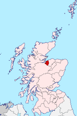
County of Nairn

Last updated

County of Nairn
Nairnshire-Scotland.svg
Country Scotland
County town Nairn
Area
  Total200 sq mi (518 km2)
 Ranked 31st of 34
Chapman code
NAI

The County of Nairn (also called Nairnshire) (Scottish Gaelic : Siorrachd Inbhir Narann) is a historic county, registration county and lieutenancy area of Scotland. The county was used for local administration until the county council, based at the county town of Nairn, was abolished in 1975 under the Local Government (Scotland) Act 1973, the area becoming one of the eight districts of the two-tier Highland region. This arrangement ended in 1996 when the Highland council area was made a unitary authority.

Contents

The county borders Inverness-shire to the west and south, Moray to the east, and has a coastline along the Moray Firth to its north.

Geography

NairnshireTraditional.png
County of Nairn, To 1891
The 13th-century Rait Castle, near Nairn Rait Castle.jpg
The 13th-century Rait Castle, near Nairn
Dunearn hill fort Colindoune - geograph.org.uk - 540928.jpg
Dunearn hill fort

Nairnshire is about 22 miles in length and 15 miles in breadth (35×24 km); comprising an area of 200 square miles (520 km2), or 128,000 acres. [1] The county consists of a flattish coastal region where the vast majority of the population live, with a sparsely populated hilly interior, rising to the foothills of the Grampian Mountains in the south. These moorlands reach 634 m (2,080 ft) at Carn nam Bain-tighearna, on the county march (boundary) just east of Slochd summit on the A9. There is no old-established name for these heights, but they have been termed the "Nairnshire Hills". [2] The coast forms an arc shape, with the Whiteness Head peninsula in the west and The Bar peninsula in the east. The main rivers are the River Nairn and the Findhorn, which both follow deeply incised courses across the general slope northwards. [3] The chief bodies of water are Loch Loy, Cran Loch, Clunas Reservoir, Loch of Boath and Loch Kirkcaldy.

Nairn can be seen from several distant points such as Ben Rinnes, a peak that is a common point of distant view to such places as Inverness-shire and Longman Hill in Banffshire. To the north, Nairn is bounded by the Moray Firth. [4]

Functions

Nairn (Scottish Gaelic : Inbhir Narann) is a land registration county. [5]

Nairn is a lieutenancy area, defined as the district of Nairn as abolished as a local government area under the Local Government (Scotland) Act 1994. [6]

Since 1996 it has had no formal meaning in terms of local government.

Local Government

19th century

Nairn Town and County Buildings Former Court House, High Street, Nairn (geograph 5856949).jpg
Nairn Town and County Buildings

Until 1891 Nairnshire had a number of exclaves in other counties, the most considerable of which was situated some distance away from the bulk of the county of Nairn, in the county of Inverness. Another sizable portion existed in the County of Ross, around the village of Urquhart, on the Black Isle. Other, smaller, detached parts existed in the County of Moray. Under the Local Government (Scotland) Act 1889, these detached parts became part of their host territories. [7]

The Local Government (Scotland) Act 1889 established a uniform system of county councils in Scotland and realigned the boundaries of many of Scotland's counties. Subsequently, Nairn County Council was created in 1890. The new county council was based at Nairn Town and County Buildings. [8] However, Nairn County Council amalgamated with Moray County Council for almost all aspects of administration in 1930. [9]

20th century

In 1927 Nairnshire, along with many of Scotland's other counties, matriculated a coat of arms by the Lord Lyon King of Arms, the governor of Scotland's heraldry. The arms was as follows: Or, a chevron gules, between two water-bougets in chief and a stag's head cabossed in base sable, three mullets argent. The motto was UNITE AND BE MINDFUL. [10]

In 1975, under the Local Government (Scotland) Act 1973, the local government council was superseded and the area (including the burgh of Nairn) became, without change of boundaries, a council district of the two-tier Highland region.

Local government council functions were divided between the regional council and the district council. For example, education was a regional responsibility, and housing was a district responsibility.

In 1996, under the Local Government etc (Scotland) Act 1994, the local government council district was merged into the unitary Highland council area.

The new unitary Highland Council adopted the areas of the former council districts as management areas. Each management area was represented, initially, by area committees consisting of councillors elected from areas (groups of local government wards) corresponding to the management areas, but changes to ward boundaries in 1999 created a mismatch between committee areas and management areas.

21st century

In 2007, following further changes to ward boundaries, the Local Government council created a new management structure, with three new corporate management areas and 16 new ward-level management areas. Therefore, Nairn is now both one of the 22 wards of the Highland council area and one of the Highland Council's 16 ward-level management areas.

The Nairn ward elects four of the council's 80 members by the single transferable vote system of election, which is designed to produce a form of proportional representation. The ward is on the boundary between the Highland council area and the Moray council area, which lies to the east.

Within the Highland area there is the Badenoch and Strathspey ward and the Inverness South ward to the south, and the Culloden and Ardersier ward to the west.

The Nairn ward is one of nine within the Highland Council's Inverness, Nairn and Badenoch and Strathspey corporate area, and the Nairn management area is one of six ward-level management areas within the corporate area.

There is significant difference between the boundaries of the new Nairn management area and those of the area abolished in 2007. The new area is smaller, part of the old area being now within the Culloden and Ardersier ward-level area and within Inverness city ward-level area 4.

Civil parishes

Nairnshire c.1851 1861 MORAYSHIRE (Elginshire) & NAIRNSHIRE.jpg
Nairnshire c.1851

Civil parishes are still used for some statistical purposes, and separate census figures are published for them. As their areas have been largely unchanged since the 19th century this allows for comparison of population figures over an extended period of time.

The county consisted of the royal burgh of Nairn (chartered in 1476), the four parishes of Ardclach, Auldearn, Dyke & Moy and Nairn; and most of the parish of Cawdor (also known as Calder), and parts of those of: Croy & Dalcross; Moy & Dalarossie; Petty; and Urquhart & Logie Wester. [1] [7] [11]

Parliamentary constituencies

The parliamentary constituency for the Westminster Parliament is Inverness, Nairn, Badenoch and Strathspey and the MP is Drew Hendry of the Scottish National Party.

The parliamentary constituency for the Scottish Parliament is Inverness and Nairn, represented by Fergus Ewing MSP.

Transport

The Aberdeen–Inverness railway line runs through the north of the county west–east.

Settlements

Church in Nairn Scotland Nairn Church.jpg
Church in Nairn

Notes and references

  1. 1 2 Nairnshire, in A Topographical Dictionary of Scotland by Samuel Lewis (1846), pp. 298-309, accessed 2 March 2008
  2. Jarman D (2017): Very long-term landscape evolution - a geomorphological contextual approach. In Merritt JW, Auton CA and Phillips E (eds) The Quaternary around Nairn and the Inverness Firth - Field Guide. Quaternary Research Association, London, 18-27
  3. Jarman D (2017): Very long-term landscape evolution - a geomorphological contextual approach. In Merritt JW, Auton CA and Phillips E (eds) The Quaternary around Nairn and the Inverness Firth - Field Guide. Quaternary Research Association, London, 18-27.
  4. New Boundary Maps/Wards, Highland Council website Archived 2008-02-15 at the Wayback Machine
  5. "Land Register Counties" Archived 2010-02-02 at the Wayback Machine . Registers of Scotland. Retrieved 27 July 2013.
  6. "The Lord-Lieutenants (Scotland) Order 1996". The National Archives. Retrieved 27 July 2013.
  7. 1 2 "Relationships / unit history of Nairnshire, Vision of Britain, accessed April 2, 2008". Archived from the original on 1 October 2007. Retrieved 2 April 2008.
  8. Historic Environment Scotland. "Former Court House including prison and boundary walls to rear, High Street, Nairn (LB38427)" . Retrieved 18 November 2021.
  9. "County of Nairn". Scan. Retrieved 19 July 2021.
  10. Urquhart, R.M. Scottish Burgh and County Heraldry (1973 ed.). Heraldry Today. p. 72. consulted 20 December 2013.
  11. "Calder Parish: Clunas 1782". Am Baile. Retrieved 27 July 2013.

Coordinates: 57°30′N3°50′W / 57.500°N 3.833°W / 57.500; -3.833

Related Research Articles

Highland (council area) Council area of Scotland

Highland is a council area in the Scottish Highlands and is the largest local government area in the United Kingdom. It was the 7th most populous council area in Scotland at the 2011 census. It shares borders with the council areas of Aberdeenshire, Argyll and Bute, Moray and Perth and Kinross. Their councils, and those of Angus and Stirling, also have areas of the Scottish Highlands within their administrative boundaries.

Inverness City in the Scottish Highlands

Inverness is a city in the Scottish Highlands. It is the administrative centre for The Highland Council and is regarded as the capital of the Highlands. Historically it served as the county town of the county of Inverness-shire. Inverness lies near two important battle sites: the 11th-century battle of Blàr nam Fèinne against Norway which took place on the Aird, and the 18th century Battle of Culloden which took place on Culloden Moor. It is the northernmost city in the United Kingdom and lies within the Great Glen at its northeastern extremity where the River Ness enters the Beauly Firth. At the latest, a settlement was established by the 6th century with the first royal charter being granted by Dabíd mac Maíl Choluim in the 12th century. Inverness and Inverness-shire are closely linked to various influential clans, including Clan Mackintosh, Clan Fraser and Clan MacKenzie.

Nairn Human settlement in Scotland

Nairn is a town and former burgh in the Highland council area of Scotland. It is an ancient fishing port and market town around 17 miles (27 km) east of Inverness. It is the traditional county town of Nairnshire.

County of Moray Historic county in Scotland

Moray or Morayshire, called Elginshire until 1919, is a historic county, registration county and lieutenancy area of Scotland, bordering Nairnshire to the west, Inverness-shire to the south, and Banffshire to the east. It was a local government county, with Elgin the county town, until 1975. The county was officially called Elginshire, sharing the name of the Elginshire parliamentary constituency, so named since 1708.

Badenoch and Strathspey

Badenoch and Strathspey is a local government ward of the Highland council area and a ward management area of the Highland Council in Scotland. It was previously one of eight districts of the two-tier Highland region, 1975 to 1996, and one of eight management areas of the Highland Council, 1996 to 2007.

Caithness, Sutherland and Easter Ross (UK Parliament constituency) Parliamentary constituency in the United Kingdom, 1997 onwards

Caithness, Sutherland and Easter Ross is a constituency of the House of Commons of the Parliament of the United Kingdom (Westminster). It is the most northerly constituency on the British mainland. It elects one Member of Parliament (MP) by the first-past-the-post system of election.

Inverness, Nairn, Badenoch and Strathspey (UK Parliament constituency) Parliamentary constituency in the United Kingdom, 2005 onwards

Inverness, Nairn, Badenoch and Strathspey is a constituency of the House of Commons of the UK Parliament. As with all seats since 1955 it elects one Member of Parliament (MP) by the first past the post system of election.

Ross, Skye and Lochaber (UK Parliament constituency) Parliamentary constituency in the United Kingdom, 2005 onwards

Ross, Skye and Lochaber is a constituency of the House of Commons of the Parliament of the United Kingdom (Westminster). It elects one Member of Parliament (MP) by the first past the post system of election.

Caithness, Sutherland and Easter Ross (Scottish Parliament constituency) Region or constituency of the Scottish Parliament

Caithness, Sutherland and Easter Ross was a constituency of the Scottish Parliament (Holyrood), in use between 1999 and 2011. It elected one Member of the Scottish Parliament (MSP) by the first past the post method of election. Also, however, it was one of eight constituencies in the Highlands and Islands electoral region, which elects seven additional members, in addition to eight constituency MSPs, to produce a form of proportional representation for the region as a whole.

Ross, Skye and Inverness West (Scottish Parliament constituency)

Ross, Skye and Inverness West was a constituency of the Scottish Parliament (Holyrood). It elected one Member of the Scottish Parliament (MSP) by the first past the post method of election. Also, however, it is one of eight constituencies in the Highlands and Islands electoral region, which elects seven additional members, in addition to eight constituency MSPs, to produce a form of proportional representation for the region as a whole.

Inverness East, Nairn and Lochaber (Scottish Parliament constituency) Region or constituency of the Scottish Parliament

Inverness East, Nairn and Lochaber was a constituency of the Scottish Parliament (Holyrood). It elected one Member of the Scottish Parliament (MSP) by the first past the post method of election. It was one of eight constituencies in the Highlands and Islands electoral region, which elects seven additional members, in addition to constituency MSPs, to produce a form of proportional representation for the region as a whole.

Politics of the Highland council area

The politics of the Highland council area in Scotland are evident in the deliberations and decisions of the Highland Council, in elections to the council, and in elections to the House of Commons of the Parliament of the United Kingdom (Westminster) and the Scottish Parliament (Holyrood). In the European Parliament the area was within the Scotland constituency, which covers all of the 32 council areas of Scotland.

Highland Council wards created in 2007

The third set of Highland Council wards, 22 in number, became effective for election purposes in 2007, for the fourth general election of the Highland Council. The new wards were created under the Local Governance (Scotland) Act 2004, and are as defined in recommendations of the Local Government Boundary Commission for Scotland.

Highland Council wards 1999 to 2007

The second set of Highland Council wards, 80 in number, became effective for election purposes in 1999, for the second general election of the Highland Council, and were used also for the third general election in 2003. These wards replaced 72 older wards, and were themselves replaced by a set of 22 wards for the fourth general election in 2007.

Highland Council wards 1995 to 1999

The first set of Highland Council wards was first used for Highland Council election purposes in 1995, for the first general election of the council. They were replaced with 80 new wards for the second general election in 1999.

The Highland Council Scottish unitary authority council in Highland, Scotland, UK

The Highland Council, the political body covering the Highland local authority created in 1995, comprises 22 wards, each electing three or four councillors by the single transferable vote system, which creates a form of proportional representation. The total number of councillors is 74, and the main meeting place and main offices are in Glenurquhart Road, Inverness.

Inverness-shire Historic county in Scotland

Inverness-shire is a historic county, registration county and lieutenancy area of Scotland. Covering much of the Highlands and Outer Hebrides, it is Scotland's largest county, though one of the smallest in population, with 67,733 people or 1.34% of the Scottish population.

Inverness and Nairn (Scottish Parliament constituency) Region or constituency of the Scottish Parliament

Inverness and Nairn is a constituency of the Scottish Parliament (Holyrood) covering part of the Highland council area. It elects one Member of the Scottish Parliament (MSP) by the first past the post method of election. It is also one of eight constituencies in the Highlands and Islands electoral region, which elects seven additional members, to produce a form of proportional representation for the region as a whole.

Skye, Lochaber and Badenoch (Scottish Parliament constituency) Constituency of the Scottish Parliament

Skye, Lochaber and Badenoch is a constituency of the Scottish Parliament (Holyrood) covering part of the Highland council area. It elects one Member of the Scottish Parliament (MSP) by the first past the post method of election. Also, however, it is one of eight constituencies in the Highlands and Islands electoral region, which elects seven additional members, in addition to eight constituency MSPs, to produce a form of proportional representation for the region as a whole. In 2011 it replaced most of the constituency of Ross, Skye and Inverness West with Inverness being moved into a new seat called Inverness and Nairn.