Gordon (district)

Last updated

Gordon
Gordon.svg
Gordon district within Scotland
History
  Created16 May 1975
  Abolished31 Mar 1996
  Succeeded by Aberdeenshire
StatusDistrict
GovernmentGordon District Council
   HQ Inverurie
Gordon DC arms.png
Coat of arms of Gordon District Council

Gordon was one of five local government districts in the Grampian region of Scotland. The council was based in Inverurie. It was created in 1975 and abolished in 1996, when the area was included in the Aberdeenshire council area.

Contents

History

The district was created on 16 May 1975 under the Local Government (Scotland) Act 1973, which established a two-tier structure of local government across Scotland comprising upper-tier regions and lower-tier districts. Gordon was one of five districts created within the Grampian region. The new district covered the whole area of eight former districts and parts of another two, which were all abolished at the same time: [1] [2]

The whole area was part of the county of Aberdeenshire prior to the reforms.

Various names were considered for the new district, with alternatives including Bennachie from a range of hills in the area, Mar after one of the historic provinces of Scotland, and Donside from the River Don which flows through the area. At a meeting in March 1972 the old Aberdeenshire County Council voted in favour of recommending to the government that Gordon should be the new district's name, after the Clan Gordon which had extensive landholdings in the area, including the clan's then principal seat of Haddo House. The clan took its name from the village of Gordon in Berwickshire. [3]

The regions and districts created in 1975 were abolished in 1996, being replaced by council areas. The area of Gordon was merged with the Banff and Buchan and Kincardine and Deeside districts to become the new Aberdeenshire council area. [4]

Political control

The first election to the district council was held in 1974, initially operating as a shadow authority alongside the outgoing authorities until it came into its powers on 16 May 1975. Political control of the council from 1975 until its abolition in 1996 was as follows: [5]

Party in controlYears
No overall control 1975–1977
Independent 1977–1980
No overall control 1980–1984
Independent 1984–1988
Liberal Democrats 1988–1992
Independent 1992–1996

Premises

3 High Street, Inverurie: Council's main offices 1975-1982 Former Clydesdale Bank, High Street, Inverurie - geograph.org.uk - 3095681.jpg
3 High Street, Inverurie: Council's main offices 1975–1982

The council initially met at Inverurie Town Hall and had its main offices in a converted former bank at 3 High Street in Inverurie, with additional offices in various other locations. Shortly after the council's creation it decided to consolidate its meeting place and offices at a purpose-built headquarters. Gordon House was subsequently built on Blackhall Road in Inverurie in phases between 1980 and 1982. It also housed some departments of Grampian Regional Council. Gordon House was formally opened on 9 July 1982. [6] [7]

After the council's abolition in 1996, Gordon House became an area office for the successor Aberdeenshire Council. [8]

Coat of arms

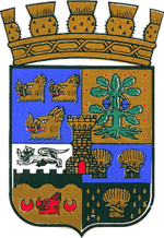
The Gordon District Council was granted a coat of arms by Lord Lyon King of Arms on 9 June 1986. The first quarter of the shield showed three gold boars' heads on a blue ground, the arms of the Gordon family, from whom the district's name was derived. The Gordon arms had formed one quarter of the arms of Aberdeenshire County Council. Boars' heads also formed part of the arms of the burgh of Huntly. The second quarter was derived from the Kintore burgh arms, showing an oak tree. The third quarter was based on the arms of the burgh of Oldmeldrum and the fourth on those of the burgh of Ellon. In the centre of the shield was a gold tower, from Inverurie's burgh arms. Above the arms was a coronet consisting of a gold circlet topped by thistle-heads: a design reserved by Lord Lyon for the arms of district councils. [9]

See also

Related Research Articles

<span class="mw-page-title-main">Aberdeenshire</span> Council area of Scotland

Aberdeenshire is one of the 32 council areas of Scotland.

<span class="mw-page-title-main">Perth and Kinross</span> Council area of Scotland

Perth and Kinross is one of the 32 council areas of Scotland, and a lieutenancy area. It is bordered by Highland and Aberdeenshire to the north, Angus, Dundee, and Fife to the east, Clackmannanshire to the south, and Stirling and Argyll and Bute to the west.

<span class="mw-page-title-main">Kincardineshire</span> Historic county in Scotland

Kincardineshire or the County of Kincardine, also known as the Mearns, is a historic county, registration county and lieutenancy area on the coast of north-east Scotland. It is bounded by Aberdeenshire on the north, and by Angus on the south-west.

<span class="mw-page-title-main">Inverurie</span> Town in northeast Scotland

Inverurie is a town in Aberdeenshire, Scotland at the confluence of the rivers Ury and Don, about 16 miles (26 km) north-west of Aberdeen.

<span class="mw-page-title-main">Grampian</span> Former local government region of Scotland

Grampian was one of nine former local government regions of Scotland created in 1975 by the Local Government (Scotland) Act 1973 and abolished in 1996 by the Local Government etc. (Scotland) Act 1994. The region took its name from the Grampian Mountains.

<span class="mw-page-title-main">Banff and Buchan</span> Modern committee area in Aberdeenshire

Banff and Buchan is a committee area of the Aberdeenshire Council, Scotland. It has a population of 35,742. Fishing and agriculture are important industries, together with associated processing and service activity.

<span class="mw-page-title-main">Kincardine and Deeside</span> Scottish local government district (1975–1996), part of Grampian region

Kincardine and Deeside was one of five local government districts in the Grampian region of Scotland. Its council was based in Stonehaven. It was created in 1975 and abolished in 1996, when the area was included in the Aberdeenshire council area.

<span class="mw-page-title-main">Ellon, Aberdeenshire</span> Town in northern Scotland

Ellon is a town in Aberdeenshire, Scotland, approximately 16 miles north of Aberdeen, lying on the River Ythan, which has one of the few undeveloped river estuaries on the eastern coast of Scotland. It is in the ancient region of Formartine. Its name is believed to derive from the Gaelic term Eilean, an island, on account of the presence of an island in the River Ythan, which offered a convenient fording point. In 1707 it was made a burgh of barony for the Earl of Buchan. It is home to a unique collection of ancient yew trees.

<span class="mw-page-title-main">Aberdeenshire (historic)</span> Historic county in Scotland

Aberdeenshire or the County of Aberdeen is a historic county and registration county of Scotland. The area of the county, excluding the Aberdeen City council area itself, is also a lieutenancy area. The county borders Kincardineshire, Angus and Perthshire to the south, Inverness-shire and Banffshire to the west, and the North Sea to the north and east. It has a coast-line of 65 miles (105 km). The county gives its name to the modern Aberdeenshire council area, which covers a larger area than the historic county.

<span class="mw-page-title-main">Kintore, Aberdeenshire</span> Human settlement in Scotland

Kintore is a town and former royal burgh near Inverurie in Aberdeenshire, Scotland, now bypassed by the A96 road between Aberdeen and Inverness. It is situated on the banks of the River Don.

<span class="mw-page-title-main">Gordon (UK Parliament constituency)</span> Parliamentary constituency in the United Kingdom, 1983 onwards

Gordon was a county constituency of the House of Commons of the Parliament of the United Kingdom (Westminster), which elected one member of Parliament (MP) by the first past the post system of election. The constituency was first contested at the 1983 UK general election; and underwent boundary throughout its existence.

Aberdeen and Kincardine Central, also known as Central Aberdeenshire, was a county constituency of the House of Commons of the Parliament of the United Kingdom from 1918 until 1950. It elected one Member of Parliament (MP) by the first past the post system of election.

EastAberdeenshire was a Scottish county constituency of the House of Commons of the Parliament of the United Kingdom from 1868 to 1918 and from 1950 to 1983. It elected one Member of Parliament (MP) by the first past the post system of election.

WestAberdeenshire was a Scottish county constituency of the House of Commons of the Parliament of the United Kingdom from 1868 to 1918 and from 1950 to 1983. It elected one Member of Parliament (MP) by the first past the post system of election.

<span class="mw-page-title-main">Oldmeldrum</span> Human settlement in Scotland

Oldmeldrum is a village and parish in the Formartine area of Aberdeenshire, not far from Inverurie in North East Scotland. With a population of around 2,187, Oldmeldrum falls within Scotland's top 300 centres of population. Oldmeldrum is home to one of the oldest whisky distilleries in Scotland, Glen Garioch, which was built in 1797. Local industries are agriculture and engineering services connected to the oil industry in Aberdeen.

<span class="mw-page-title-main">Methlick</span> Human settlement in Scotland

Methlick is a village in the Formartine area of Aberdeenshire, Scotland, situated on the River Ythan 11.2 kilometres (7.0 mi) north-west of Ellon.

Garioch RFC is a rugby union club based in Inverurie, Scotland. The Men's team currently plays in Caledonia Division One. The Women's team currently plays in the Scottish Womens Premiership league.

<span class="mw-page-title-main">Inverurie Town Hall</span> Municipal building in Inverurie, Scotland

Inverurie Town Hall is a municipal building in the Market Place in Inverurie, Scotland. The structure, which served as the meeting place of Inverurie Burgh Council, is a Category B listed building.

<span class="mw-page-title-main">Kintore Town House</span> Municipal building in Kintore, Scotland

Kintore Town House is a municipal structure in The Square, Kintore, Aberdeenshire, Scotland. The structure, which is used as commercial offices, is a Category A listed building.

<span class="mw-page-title-main">Oldmeldrum Town Hall</span> Municipal building in Oldmeldrum, Scotland

Oldmeldrum Town Hall is a municipal structure in the Market Square, Oldmeldrum, Aberdeenshire, Scotland. The structure, which is used as a community events venue, is a Category B listed building.

References

  1. "Local Government (Scotland) Act 1973", legislation.gov.uk , The National Archives, 1973 c. 65, retrieved 22 November 2022
  2. "Quarter-inch Administrative Areas Maps of Scotland, Sheet 5: Aberdeenshire, Banffshire, Kincardineshire, Morayshire and Nairnshire, 1969". National Library of Scotland. Ordnance Survey. Retrieved 11 August 2024.
  3. "Council say Gordon for us". Evening Express. Aberdeen. 17 March 1972. p. 11. Retrieved 12 August 2024.
  4. "Local Government etc. (Scotland) Act 1994", legislation.gov.uk , The National Archives, 1994 c. 39, retrieved 16 December 2022
  5. "Compositions calculator". The Elections Centre. Retrieved 12 August 2024.
  6. Gill, Jane (8 July 1982). "Gordon's good housekeeping buys a new home". Press and Journal. Aberdeen. p. 8. Retrieved 12 August 2024.
  7. Historic Environment Scotland. "Inverurie, Blackhall Road, Gordon House, Gordon District Council Headquarters (274159)". Canmore . Retrieved 13 September 2021.
  8. "Area manager teams". Aberdeenshire Council. Retrieved 11 August 2024.
  9. R.M. Urquhart, Scottish Civic Heraldry 2, Hamilton, 2001