The Stirling council area (Scots: Stirlin; Scottish Gaelic: Sruighlea) is one of the 32 council areas of Scotland, and has an estimated population of 94,210 (2024).[2] It was created in 1975 as a lower-tier district within the Centralregion. The district covered parts of the historic counties of Stirlingshire and Perthshire, which were abolished for local government purposes. In 1996 the Central region was abolished and Stirling Council took over all local government functions within the area.
The majority of the population of the area is located in its southeast corner, in the city of Stirling and in the surrounding lowland communities: Bridge of Allan and Dunblane to the north, Bannockburn to the immediate south, and the three former coal mining communities of Cowie, Fallin, and Plean, known collectively as the "Eastern Villages".
The rest of the council area's population is sparsely distributed across the rural, mainly highland, expanse in the north and west of the area. The southern half of this rural area comprises the flat western floodplain of the River Forth, bounded on the south by the Touch Hills and the Campsie Fells. North of the glen lie the Trossachs mountains, and the northern half of the council area is generally mountainous in character.
Local government was reformed again in 1996 under the Local Government etc. (Scotland) Act 1994, which abolished the regions and districts which had been created in 1975, replacing them with unitary council areas. Central Region was abolished and each of the area's three districts, including Stirling, became council areas. Stirling District Council was therefore replaced by the current Stirling Council.[5]
Demography
Languages
The 2022 Scottish Census reported that out of 90,451 residents aged three and over, 27,348 (30.2%) considered themselves able to speak or read the Scots language. [6]
The 2022 Scottish Census reported that out of 90,449 residents aged three and over, 1,202 (1.3%) considered themselves able to speak or read Gaelic.[6]
The council has been under no overall control since 2007. Following the 2022 election a Labourminority administration formed to run the council.[8][9] Efforts by the Scottish National Party as the largest party on the council to take over the leadership in February 2025 were unsuccessful, with the council narrowly voting for the Labour minority administration to continue.[10] In October 2025 the SNP gained a seat following a by-election in Stirling East, and in November 2025 a deal was agreed between the SNP and Green and independent councillors to take control of the council.[11]
The first election to Stirling District Council was held in 1974, initially operating as a shadow authority alongside the outgoing authorities until the new system came into force on 16 May 1975. A shadow authority was again elected in 1995 ahead of the change to council areas which came into force on 1 April 1996. Political control since 1975 has been as follows:[12]
The role of provost is largely ceremonial in Stirling. They chair full council meetings and act as the council's civic figurehead. Political leadership is provided by the leader of the council. The first leader of the council, Corrie McChord, had been the last leader of the Central Regional Council.[13] The leaders since 1996 have been:
A by-election was held on 15 August 2024 to fill a vacancy caused by the resignation of Ewan Dillon. Following Chris Kane being elected as MP for Stirling and Strathallan, Labour Councillor Margaret Brisley became leader of the Council, but died on 27 October 2024,[29] and a by-election was held to fill the vacancy caused by her death. The next full council election is due in 2027.[30]
Premises
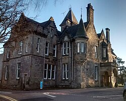
Old Viewforth: The 1937 wing behind the original house
The council is based at Old Viewforth on Pitt Terrace in Stirling. The oldest part of the building is a converted house called Viewforth, which had been built in 1855.[31] The house was bought by Stirlingshire County Council in 1931 for £5,250 and converted to become its headquarters.[32] A large art deco extension was added to the rear of the house, opening in 1937.[33] A new building called New Viewforth was built alongside the older premises in 1972, shortly before Stirlingshire County Council was abolished.[34]
Between 1975 and 1996 the premises at Viewforth served as the headquarters of Central Regional Council, whilst Stirling District Council was based at the Municipal Buildings at 8–10 Corn Exchange Road in Stirling, which had been completed in 1918 for the old Stirling Town Council.[35][36] On local government reorganisation in 1996 Stirling Council took over Viewforth. The 1972 building known as New Viewforth was demolished in 2014.[37]
1 2 "Compositions Calculator". The Elections Centre. University of Exeter. Retrieved 21 May 2025. (Put "Stirling" in search box to see specific results.)
This page is based on this Wikipedia article Text is available under the CC BY-SA 4.0 license; additional terms may apply. Images, videos and audio are available under their respective licenses.